Remote Sensing of Environment ( IF 11.1 ) Pub Date : 2021-10-29 , DOI: 10.1016/j.rse.2021.112752 Alexandra Runge 1, 2 , Ingmar Nitze 1 , Guido Grosse 1, 2
|
Permafrost is warming globally which leads to widespread permafrost thaw. Particularly ice-rich permafrost is vulnerable to rapid thaw and erosion, impacting whole landscapes and ecosystems. Retrogressive thaw slumps (RTS) are abrupt permafrost disturbances that expand by several meters each year and lead to an increased soil organic carbon release. Local Remote Sensing studies identified increasing RTS activity in the last two decades by increasing number of RTS or heightened RTS growth rates. However, a large-scale assessment across diverse permafrost regions and at high temporal resolution allowing to further determine RTS thaw dynamics and its main drivers is still lacking.
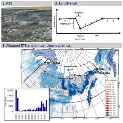
In this study we apply the disturbance detection algorithm LandTrendr for automated large-scale RTS mapping and high temporal thaw dynamic assessment to North Siberia (8.1 × 10⁶km2). We adapted and parametrised the temporal segmentation algorithm for abrupt disturbance detection to incorporate Landsat+Sentinel-2 mosaics, conducted spectral filtering, spatial masking and filtering, and a binary machine-learning object classification of the disturbance output to separate between RTS and false positives (F1 score: 0.609). Ground truth data for calibration and validation of the workflow was collected from 9 known RTS cluster sites using very high-resolution RapidEye and PlanetScope imagery.
Our study presents the first automated detection and assessment of RTS and their temporal dynamics at large-scale for 2001–2019. We identified 50,895 RTS and a steady increase in RTS-affected area from 2001 to 2019 across North Siberia, with a more abrupt increase from 2016 onward. Overall the RTS-affected area increased by 331% compared to 2000 (2000: 20,158 ha, 2001–2019: 66,699 ha). Contrary to this, 5 focus sites show spatio-temporal variability in their annual RTS dynamics, with alternating periods of increased and decreased RTS development, indicating a close relationship to thaw drivers. The majority of identified RTS was active from 2000 onward and only a small proportion initiated during the assessment period, indicating that the increase in RTS-affected area was mainly caused by enlarging existing RTS and not by new RTS. The detected increase in RTS dynamics suggests advancing permafrost thaw and underlines the importance of assessing abrupt permafrost disturbances with high spatial and temporal resolution at large-scales. Obtaining such consistent disturbance products will help to parametrise regional and global climate change models.
中文翻译:
使用 LandTrendr 遥感快速永久冻土融化扰动的年度动态
永久冻土正在全球变暖,导致永久冻土广泛融化。特别是富含冰的永久冻土容易受到快速解冻和侵蚀,影响整个景观和生态系统。倒退性融化坍塌 (RTS) 是一种突然的永久冻土扰动,每年扩大几米,导致土壤有机碳释放增加。本地遥感研究通过增加 RTS 数量或提高 RTS 增长率确定了过去 20 年中 RTS 活动的增加。然而,仍然缺乏对不同永久冻土区域和高时间分辨率的大规模评估,以进一步确定 RTS 解冻动态及其主要驱动因素。
在这项研究中,我们将干扰检测算法 LandTrendr 应用于北西伯利亚 (8.1 × 10 6 km 2 ) 的自动大规模 RTS 制图和高时间解冻动态评估。我们对用于突然干扰检测的时间分割算法进行了调整和参数化,以结合 Landsat+Sentinel-2 马赛克,进行光谱滤波、空间掩蔽和滤波,以及干扰输出的二进制机器学习对象分类,以区分 RTS 和误报( F1 分数:0.609)。使用非常高分辨率的 RapidEye 和 PlanetScope 图像从 9 个已知的 RTS 集群站点收集用于校准和验证工作流程的地面实况数据。
我们的研究首次对 RTS 及其 2001-2019 年大规模的时间动态进行了自动检测和评估。我们确定了 50,895 个 RTS,并且从 2001 年到 2019 年,整个北西伯利亚受 RTS 影响的区域稳步增加,从 2016 年开始增加更加突然。总体而言,受 RTS 影响的面积与 2000 年相比增加了 331%(2000 年:20,158 公顷,2001-2019 年:66,699 哈)。与此相反,5 个重点站点在其年度 RTS 动态中显示出时空变异性,RTS 发展的增加和减少交替出现,表明与解冻驱动因素密切相关。大多数已识别的 RTS 是从 2000 年开始活跃的,只有一小部分是在评估期间启动的,表明受 RTS 影响的面积增加主要是由于扩大现有 RTS 而不是新的 RTS。检测到的 RTS 动态增加表明永久冻土融化的推进,并强调了评估具有高空间和时间分辨率的大尺度突然永久冻土扰动的重要性。获得这种一致的干扰产物将有助于参数化区域和全球气候变化模型。


 京公网安备 11010802027423号