International Journal of Applied Earth Observation and Geoinformation ( IF 7.6 ) Pub Date : 2021-10-12 , DOI: 10.1016/j.jag.2021.102584 Rahul Raj 1, 2, 3 , Jeffrey P. Walker 2 , Rohit Pingale 3 , Balaji Naik Banoth 4 , Adinarayana Jagarlapudi 3
|
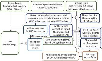
Remote estimation of leaf nitrogen content is a critical requirement for precision farm management. Precise knowledge of nitrogen distribution in the crop enables farmers to decide the fertilisation amount required at specific locations on the farm. Importantly, nitrogen related molecules in plants are transported using water molecules, and water molecules surround the amide bonds (a plant protein created from nitrogen). Consequently, the nitrogen in various crop parts loses its activity in the absence of sufficient water molecules. The association of water molecules around plant proteins makes the optical remote estimation of plant nitrogen challenging as nitrogen and water molecules simultaneously affect the reflectance data. Moreover, the coarse spatial resolution of satellite data and sparse canopy coverage at early growth stages of the crop make it challenging to estimate leaf-level nitrogen contents. Accordingly, this research developed a leaf nitrogen content estimation model using drone-based top-of-canopy 400–1000 nm pure pixel hyperspectral images collected from a maize research farm treated with different water and nitrogen levels. Leaf level spectral signatures were also collected using a field spectroradiometer and used to identify indices more sensitive to nitrogen than water. The leaves were also destructively sampled for obtaining ground truth leaf water and nitrogen content. Red-edge region bands of electromagnetic spectra were identified to be sensitive to leaf nitrogen content. A synthetic data was created using maximum and minimum values of these indices and crop growth stage information, which was further used for training a gradient-boosting machine model to estimate leaf nitrogen content from drone-based hyperspectral images. The estimated leaf nitrogen content values from drone observations were critically analysed with respect to leaf water content values. For water-stressed areas, the model gave an R2 and RMSE of 0.63 and 2.74 mg/g, respectively. However, the model did not perform adequately for well irrigated areas, having an R2 and RMSE of 0.26 and 4.54 mg/g, respectively.
中文翻译:
使用冠层空气高光谱数据估算叶片氮含量
叶片氮含量的远程估计是精确农场管理的关键要求。对作物中氮分布的精确了解使农民能够决定农场特定位置所需的施肥量。重要的是,植物中与氮相关的分子是通过水分子运输的,而水分子围绕着酰胺键(一种由氮产生的植物蛋白)。因此,在缺乏足够的水分子的情况下,不同作物部位的氮会失去其活性。由于氮和水分子同时影响反射率数据,植物蛋白质周围水分子的关联使得植物氮的光学远程估计具有挑战性。而且,卫星数据的粗略空间分辨率和作物早期生长阶段稀疏的冠层覆盖使得估计叶片水平的氮含量具有挑战性。因此,本研究使用从用不同水和氮水平处理的玉米研究农场收集的基于无人机的冠层顶部 400-1000 nm 纯像素高光谱图像开发了一种叶片氮含量估计模型。还使用现场光谱仪收集了叶级光谱特征,并用于识别对氮比对水更敏感的指数。还对叶子进行了破坏性采样,以获得真实的叶子水和氮含量。电磁光谱的红边区域带被确定为对叶氮含量敏感。使用这些指数的最大值和最小值以及作物生长阶段信息创建合成数据,该数据进一步用于训练梯度提升机器模型,以从基于无人机的高光谱图像中估计叶片氮含量。从无人机观察中估计的叶氮含量值就叶含水量值进行了严格分析。对于缺水地区,该模型给出了 R2和 RMSE 分别为 0.63 和 2.74 mg/g。然而,该模型在灌溉良好的地区表现不佳,其 R 2和 RMSE 分别为 0.26 和 4.54 mg/g。


 京公网安备 11010802027423号