当前位置:
X-MOL 学术
›
Basin Res.
›
论文详情
Our official English website, www.x-mol.net, welcomes your
feedback! (Note: you will need to create a separate account there.)
Shoreline evolution from the Late Cretaceous to the Miocene: A record of eustasy, tectonics and palaeoceanography in the Gippsland Basin
Basin Research ( IF 2.8 ) Pub Date : 2021-10-09 , DOI: 10.1111/bre.12620 E. M. Mahon 1 , M. W. Wallace 1
Basin Research ( IF 2.8 ) Pub Date : 2021-10-09 , DOI: 10.1111/bre.12620 E. M. Mahon 1 , M. W. Wallace 1
Affiliation
|
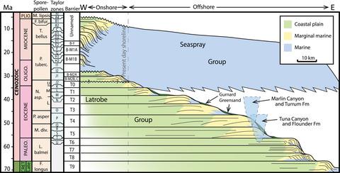
Well-developed clastic shoreline systems have been deposited in the Gippsland Basin over a 70 Ma period, from the latest Cretaceous to the present day. Twenty-three stacked coastal units have been mapped and described in the Traralgon and Balook formations of the Latrobe and Seaspray groups. These units are made up of prograding and backstepping shoreface deposits, which, in plan view, display well-developed strandline geometries at the terrestrial–marine interface. Shoreface deposits are interpreted to include prograding beach, barrier island and transgressive beach deposits. The lower coastal plain is characterised by persistent deposition of coals despite changes in shoreface type and significant palaeoclimate fluctuations. These coastal deposits display approximately 123 km of transgression from the Late Cretaceous shoreline at the base of the study interval to the mid Miocene Yallourn Formation near the top. The Late Cretaceous and Palaeocene shoreline deposits individually prograde and are separated by flooding surfaces reflecting eustatic changes. Overall they display long-term backstepping behaviour (retrogradation) as a result of basin subsidence. Though shorelines of the Eocene–Miocene are distinctly transgressional, probably reflecting basin subsidence, in the mid-Miocene they become individually and collectively progradational. A series of unconformities in the Oligocene, coupled with Miocene progradation, likely reflects a combination of a compressional tectonic regime and glacioeustatic fluctuations. Despite major changes in the tectonics and palaeoclimate, basin subsidence appears to be the dominant driver for changes in shoreline location.
中文翻译:

从晚白垩世到中新世的海岸线演化:吉普斯兰盆地的洋流、构造和古海洋学记录
从最近的白垩纪到现在,吉普斯兰盆地已经在 70 Ma 期间沉积了发育良好的碎屑海岸线系统。在 Latrobe 和 Seaspray 组的 Traralgon 和 Balook 组中绘制并描述了 23 个堆叠的沿海单元。这些单元由前进和后退的岸面沉积物组成,在平面图中,在陆地-海洋界面处显示出发育良好的索状线几何形状。岸面沉积物被解释为包括前进海滩、屏障岛和海进海滩沉积物。下沿海平原的特点是煤的持续沉积,尽管海岸类型发生了变化和古气候显着波动。这些海岸沉积物显示从研究区间底部的晚白垩世海岸线到顶部附近的中新世中期 Yallourn 组的海侵约 123 公里。晚白垩世和古新世海岸线沉积物分别前进,并被反映海平面变化的泛滥表面隔开。总体而言,由于盆地沉降,它们表现出长期的倒退行为(回退)。虽然始新世-中新世的海岸线明显海侵,可能反映盆地沉降,但在中新世中期,它们变得单独和集体地推进。渐新世的一系列不整合,加上中新世的推进,可能反映了挤压构造机制和冰川运动波动的结合。
更新日期:2021-10-09
中文翻译:
从晚白垩世到中新世的海岸线演化:吉普斯兰盆地的洋流、构造和古海洋学记录
从最近的白垩纪到现在,吉普斯兰盆地已经在 70 Ma 期间沉积了发育良好的碎屑海岸线系统。在 Latrobe 和 Seaspray 组的 Traralgon 和 Balook 组中绘制并描述了 23 个堆叠的沿海单元。这些单元由前进和后退的岸面沉积物组成,在平面图中,在陆地-海洋界面处显示出发育良好的索状线几何形状。岸面沉积物被解释为包括前进海滩、屏障岛和海进海滩沉积物。下沿海平原的特点是煤的持续沉积,尽管海岸类型发生了变化和古气候显着波动。这些海岸沉积物显示从研究区间底部的晚白垩世海岸线到顶部附近的中新世中期 Yallourn 组的海侵约 123 公里。晚白垩世和古新世海岸线沉积物分别前进,并被反映海平面变化的泛滥表面隔开。总体而言,由于盆地沉降,它们表现出长期的倒退行为(回退)。虽然始新世-中新世的海岸线明显海侵,可能反映盆地沉降,但在中新世中期,它们变得单独和集体地推进。渐新世的一系列不整合,加上中新世的推进,可能反映了挤压构造机制和冰川运动波动的结合。


 京公网安备 11010802027423号