当前位置:
X-MOL 学术
›
Remote Sens. Ecol. Conserv.
›
论文详情
Our official English website, www.x-mol.net, welcomes your
feedback! (Note: you will need to create a separate account there.)
A convolutional neural network architecture designed for the automated survey of seabird colonies
Remote Sensing in Ecology and Conservation ( IF 3.9 ) Pub Date : 2021-10-05 , DOI: 10.1002/rse2.240 Hieu Le 1 , Dimitris Samaras 1 , Heather J. Lynch 2, 3
Remote Sensing in Ecology and Conservation ( IF 3.9 ) Pub Date : 2021-10-05 , DOI: 10.1002/rse2.240 Hieu Le 1 , Dimitris Samaras 1 , Heather J. Lynch 2, 3
Affiliation
|
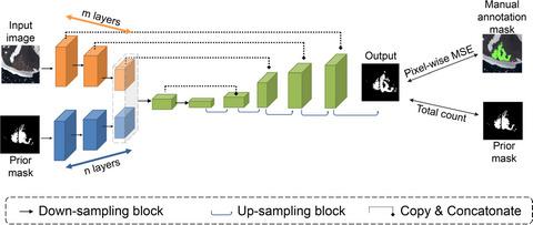
Satellite imagery is now well established as a method of finding and estimating the abundance of Antarctic penguin colonies. However, the delineation and classification of penguin colonies in sub-meter satellite imagery has required the use of expert observers and is highly labor intensive, precluding regular censuses at the pan-Antarctic scale. Here we present the first automated pipeline for the segmentation and classification of seabird colonies in high-resolution satellite imagery. Our method leverages site-fidelity by using images from previous years to improve classification performance but is robust to georegistration artifacts imposed by misalignment between sensors or terrain correction. We use a segmentation network with an additional branch that extracts the useful information from the prior mask of the input image. This prior branch provides the main model information on the location and size of guano in a prior annotation yet automatically learns to compensate for potential misalignment between the prior mask and the input image being classified. Our approach outperforms the previous approach by 44%, improving the average Intersection-over-Union segmentation score from 0.34 to 0.50. While penguin guano remains a challenging target for segmentation due to its indistinct and highly variable appearance, the inclusion of prior information represents a key step toward automated image annotation for population monitoring. Moreover, this method can be adapted for other ecological applications where the dynamics of landscape change are slow relative to the repeat frequency of available imagery and prior information may be available to aid with image annotation.
中文翻译:

一种卷积神经网络架构,专为自动调查海鸟群落而设计
卫星图像现在已成为一种发现和估计南极企鹅群落丰度的方法。然而,在亚米级卫星图像中对企鹅群落的描绘和分类需要使用专家观察员,并且是高度劳动密集型的,无法在泛南极范围内进行定期人口普查。在这里,我们展示了第一个用于高分辨率卫星图像中海鸟群落分割和分类的自动化管道。我们的方法通过使用前几年的图像来利用站点保真度来提高分类性能,但对传感器之间的未对准或地形校正造成的地理配准伪影具有鲁棒性。我们使用带有附加分支的分割网络,该分支从输入图像的先前掩码中提取有用信息。这个先验分支在先验注释中提供有关鸟粪位置和大小的主要模型信息,但会自动学习补偿先验掩码和被分类的输入图像之间的潜在错位。我们的方法比之前的方法好 44%,将平均 Intersection-over-Union 分割分数从 0.34 提高到 0.50。虽然企鹅鸟粪由于其模糊和高度可变的外观仍然是一个具有挑战性的分割目标,但包含先验信息代表了朝着用于人口监测的自动化图像注释迈出的关键一步。此外,这种方法可以适用于其他生态应用,其中景观变化的动态相对于可用图像的重复频率很慢,并且可以使用先验信息来帮助图像注释。
更新日期:2021-10-05
中文翻译:
一种卷积神经网络架构,专为自动调查海鸟群落而设计
卫星图像现在已成为一种发现和估计南极企鹅群落丰度的方法。然而,在亚米级卫星图像中对企鹅群落的描绘和分类需要使用专家观察员,并且是高度劳动密集型的,无法在泛南极范围内进行定期人口普查。在这里,我们展示了第一个用于高分辨率卫星图像中海鸟群落分割和分类的自动化管道。我们的方法通过使用前几年的图像来利用站点保真度来提高分类性能,但对传感器之间的未对准或地形校正造成的地理配准伪影具有鲁棒性。我们使用带有附加分支的分割网络,该分支从输入图像的先前掩码中提取有用信息。这个先验分支在先验注释中提供有关鸟粪位置和大小的主要模型信息,但会自动学习补偿先验掩码和被分类的输入图像之间的潜在错位。我们的方法比之前的方法好 44%,将平均 Intersection-over-Union 分割分数从 0.34 提高到 0.50。虽然企鹅鸟粪由于其模糊和高度可变的外观仍然是一个具有挑战性的分割目标,但包含先验信息代表了朝着用于人口监测的自动化图像注释迈出的关键一步。此外,这种方法可以适用于其他生态应用,其中景观变化的动态相对于可用图像的重复频率很慢,并且可以使用先验信息来帮助图像注释。


 京公网安备 11010802027423号