Global and Planetary Change ( IF 4.0 ) Pub Date : 2021-10-05 , DOI: 10.1016/j.gloplacha.2021.103670 Xin Jin 1 , Viktória Baranyi 2 , Marcello Caggiati 3 , Marco Franceschi 4 , Corey J. Wall 5 , Guanglin Liu 6 , Mark D. Schmitz 5 , Piero Gianolla 3 , James G. Ogg 1, 7 , Gang Lu 1 , Zhiqiang Shi 1 , Nereo Preto 8
|
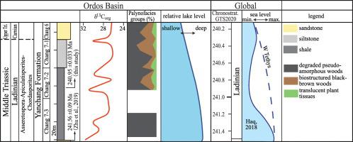
The Yanchang Formation was deposited during the Middle Triassic in a vast lacustrine basin in the modern Ordos Basin and is a main target for hydrocarbon exploration in Central China. It is divided, based on sedimentary cycles and lithology, into the Chang 10 (the oldest) to Chang 1 (the youngest) members. During the deposition of the Chang 7 Member, the Ordos lake system reached its maximum depth and large volumes of organic-rich sediments were deposited. The evolution of the Ordos Basin sedimentary system during this phase is, however, not completely understood, and uncertainty still exists as for the chronostratigraphy of Chang 7 Member. We acquired palynological markers and palynofacies and a high-resolution δ13Corg record through the entire Chang 7 Member, and a ID-TIMS 206Pb/238U date of 240.95 ± 0.033 Ma from a volcanic ash bed in the middle of this Member. These imply that the maximum deepening phase of the lacustrine system was during the earliest Ladinian. Evidence of marine influence in the Ordos Basin at that time and comparison to the sea-level oscillations observed in Western Tethys suggest that a global eustatic rise and highstand may have played a role in determining lake-level variations.
中文翻译:
与全球海平面上升有关的华北鄂尔多斯盆地中三叠统湖泊加深
延长组沉积于中三叠世现代鄂尔多斯盆地广阔的湖盆盆地,是华中地区油气勘探的主要目标。根据沉积旋回和岩性,将其分为长10(最古老)至长1(最年轻)段。长7段沉积期间,鄂尔多斯湖系达到最大深度,沉积了大量富含有机质的沉积物。但对该阶段鄂尔多斯盆地沉积体系的演化尚未完全了解,长7段年代地层学仍存在不确定性。我们通过整个长 7 成员获得了孢粉学标记和孢粉相以及高分辨率 δ 13 C组织记录,以及一个 ID-TIMS来自该成员中部火山灰层的206 Pb/ 238 U 日期为 240.95 ± 0.033 Ma。这意味着湖相系统的最大深化阶段是在最早的拉丁期。当时鄂尔多斯盆地受到海洋影响的证据以及与西特提斯海平面波动的比较表明,全球水位上升和高位可能在决定湖泊水位变化方面发挥了作用。


 京公网安备 11010802027423号