Journal of Building Engineering ( IF 6.7 ) Pub Date : 2021-09-25 , DOI: 10.1016/j.jobe.2021.103370 Shaoxiong Lai 1 , Yujie Zhao 2 , Yifan Fan 2 , Jian Ge 2
|
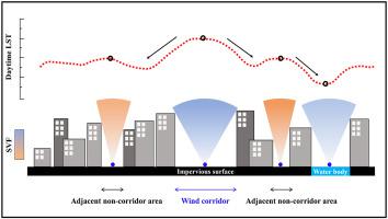
With increasing urbanisation, the fraction of built-up areas and human activities increase, deteriorating the urban thermal environment and air quality. To improve the urban environment, wind corridors have attracted much research attention in recent years. In this study, a sky-view factor (SVF)-based method is proposed and verified for the potential wind corridor detection in a built-up urban area. The proposed method accurately identified wind corridors at a spatial resolution as high as 10 m. Characteristics of daytime land surface temperature (LST) were analysed based on Landsat-8 data. Results show that daytime LST in the wind corridor is higher than that in its adjacent non-corridor areas. To quantify the effect of SVF on LST over urban ground-level surfaces, the quantitative relationship between SVF and LST was analysed in the whole study area. Mean LST was found to increase linearly with SVF at a rate of about 0.2 °C per 0.1 SVF value. Moreover, effects of the underlying surface and urban morphology on LST were also discussed. Water bodies were found to effectively reduce LST, whereas in built-up areas, LST was also affected by building height (negative correlation) and building density (positive correlation). When using building height as a variable, the mean LST difference reached 3.5 °C in four seasons, while it was only 1.2 °C between areas with different building densities. These findings are useful to urban planning and provide insights to evaluate wind corridors’ effectiveness holistically.
中文翻译:
风廊白天地表温度特征——以夏热冬暖城市为例
随着城市化程度的提高,建成区和人类活动的比例增加,城市热环境和空气质量不断恶化。近年来,为改善城市环境,风廊受到了广泛的研究关注。在这项研究中,提出并验证了一种基于天空视野因子 (SVF) 的方法,用于城市建成区的潜在风廊检测。所提出的方法以高达 10 m 的空间分辨率准确识别风廊。基于Landsat-8数据分析了白天地表温度(LST)的特征。结果表明,风廊的白天LST高于邻近的非廊道区域。为了量化 SVF 对城市地面上 LST 的影响,分析了整个研究区SVF与LST的定量关系。发现平均 LST 随 SVF 以每 0.1 SVF 值约 0.2 °C 的速率线性增加。此外,还讨论了下垫面和城市形态对 LST 的影响。发现水体可有效降低 LST,而在建成区,LST 还受建筑高度(负相关)和建筑密度(正相关)的影响。当以建筑高度为变量时,四个季节的平均LST差异达到3.5°C,而不同建筑密度区域之间的平均LST差异仅为1.2°C。这些发现对城市规划很有用,并为从整体上评估风廊的有效性提供了见解。此外,还讨论了下垫面和城市形态对 LST 的影响。发现水体可有效降低 LST,而在建成区,LST 还受建筑高度(负相关)和建筑密度(正相关)的影响。当以建筑高度为变量时,四个季节的平均LST差异达到3.5°C,而不同建筑密度区域之间的平均LST差异仅为1.2°C。这些发现对城市规划很有用,并为从整体上评估风廊的有效性提供了见解。此外,还讨论了下垫面和城市形态对 LST 的影响。发现水体可有效降低 LST,而在建成区,LST 还受建筑高度(负相关)和建筑密度(正相关)的影响。当以建筑高度为变量时,四个季节的平均LST差异达到3.5°C,而不同建筑密度区域之间的平均LST差异仅为1.2°C。这些发现对城市规划很有用,并为从整体上评估风廊的有效性提供了见解。当以建筑高度为变量时,四个季节的平均LST差异达到3.5°C,而不同建筑密度区域之间的平均LST差异仅为1.2°C。这些发现对城市规划很有用,并为从整体上评估风廊的有效性提供了见解。当以建筑高度为变量时,四个季节的平均LST差异达到3.5°C,而不同建筑密度区域之间的平均LST差异仅为1.2°C。这些发现对城市规划很有用,并为从整体上评估风廊的有效性提供了见解。


 京公网安备 11010802027423号