Journal of Hydrology ( IF 6.4 ) Pub Date : 2021-09-23 , DOI: 10.1016/j.jhydrol.2021.126977 Anuj Prakash Kushwaha 1 , Amar Deep Tiwari 2 , Swarup Dangar 2 , Harsh Shah 2 , Shanti Shwarup Mahto 1 , Vimal Mishra 1, 2
|
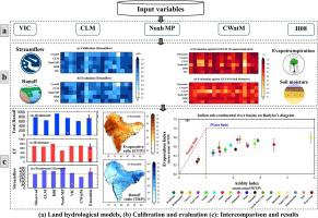
Estimation of the water budget is essential for water resources and environmental management. However, a reliable assessment of the water budget and water yield for the Indian sub-continental river basins has been lacking. We used 0.25° gridded meteorological observations and five hydrological models to construct water budget estimates for the Indian sub-continental river basins for the 1951–2016 period. The hydrological models (i.e. VIC, CLM, Noah-MP, H08, and CWatM) were calibrated against observed streamflow and evaluated for evapotranspiration (ET) and soil moisture. Considerable uncertainty in the water budget components (ET and total runoff) was found due to the process representation and parameterization of hydrological models. Multimodel ensemble mean of the five hydrological models performed better than individual models for most basins for water budget components. West coast, Brahmaputra, and Brahmani are the three wettest river basins. At the same time, Sabarmati, Indus, and Pennar are the three driest basins in terms of mean annual precipitation in the Indian sub-continent. The three transboundary river basins (Brahmaputra, Ganga, and Indus) have the highest water yield of 731.9 (±50.2), 582.4 (±89.4), and 231.1(±71) km3, respectively. The Budyko framework showed that only two basins (West Coast and the Brahmaputra) over the Indian sub-continent fall under the energy-limited (relatively lower atmospheric water demands) conditions. In comparison, the other sixteen river basins are in water-limited (higher atmospheric water demands) condition. Our findings have implications for water resources planning and management in one of the world's most populated regions.
中文翻译:
印度次大陆流域水资源收支的多模型评估
水资源预算的估算对于水资源和环境管理至关重要。然而,一直缺乏对印度次大陆河流流域的水收支和产水量的可靠评估。我们使用 0.25° 网格气象观测和五个水文模型来构建 1951-2016 年期间印度次大陆河流流域的水预算估计。水文模型(即 VIC、CLM、Noah-MP、H08 和 CWatM)根据观测到的流量进行校准,并评估蒸散量 (ET) 和土壤水分。由于水文模型的过程表示和参数化,在水收支组成部分(ET 和总径流)中发现了相当大的不确定性。对于大多数流域的水收支组成部分,五个水文模型的多模型集合平均值比单个模型表现更好。西海岸、雅鲁藏布江和婆罗门是三个最潮湿的河流流域。同时,萨巴尔马蒂、印度河和彭纳尔是印度次大陆年平均降水量最干旱的三个盆地。三个跨界流域(雅鲁藏布江、恒河和印度河)的产水量最高,分别为 731.9(±50.2)、582.4(±89.4)和 231.1(±71)公里3、分别。Budyko 框架表明,印度次大陆上只有两个盆地(西海岸和雅鲁藏布江)处于能源受限(大气需水量相对较低)条件下。相比之下,其他 16 个流域处于水资源有限(更高的大气需水量)状态。我们的发现对世界上人口最多的地区之一的水资源规划和管理具有重要意义。


 京公网安备 11010802027423号