Journal of Hydrology ( IF 5.9 ) Pub Date : 2021-09-20 , DOI: 10.1016/j.jhydrol.2021.126957 Elie Abrial 1 , Rodrigo E. Lorenzón 1 , Ana P. Rabuffetti 1 , Martin C.M. Blettler 1 , Luis A. Espínola 1
|
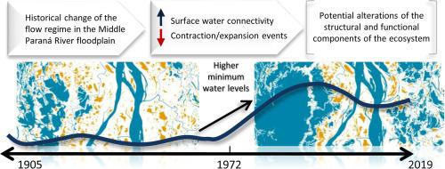
The Paraná River is ranked among the top-ten major rivers of the world. During the last century, the expansion of agriculture and the construction of large dams strongly modified the upper basin but the middle and lower sections are still among the few free-flowing river reaches of this magnitude in the world. However, the great anthropic pressure in the upper basin coupled with the climate variability of the past fifty years affected the hydrology of the lower reaches. In this study, we analyzed the hydrological characteristics of the flow regime from 1905 to 2019. Based on 10 m-resolution satellite images, we performed a cartography of the surface waters covering 15% of the Middle Paraná River floodplain and we analyzed the processes of connectivity for each 50 cm of the river height. We related the hydrological changes with the landscape analyses and discussed their potential implication on the ecosystem functioning. In other words, we highlighted how a regional disturbance in a large river basin affects some hydro-geomorphological processes several hundreds of kilometers downstream, which potentially involves long-term alterations of the structural and functional components of the biota.
中文翻译:
巴拉那河中部漫滩长期流量变化的水文生态意义
巴拉那河是世界十大河流之一。在上个世纪,农业的扩张和大坝的建设极大地改变了上流域,但中下段仍然是世界上为数不多的自由流动的河流。然而,上流域巨大的人为压力加上过去五十年的气候变率,影响了下流域的水文。在本研究中,我们分析了 1905 年至 2019 年流态的水文特征。基于 10 m 分辨率的卫星图像,我们对覆盖中巴拉那河漫滩 15% 的地表水进行了制图,并分析了流态的过程。每 50 厘米河流高度的连通性。我们将水文变化与景观分析联系起来,并讨论了它们对生态系统功能的潜在影响。换句话说,我们强调了大型流域的区域干扰如何影响下游数百公里处的一些水文地貌过程,这可能涉及生物群结构和功能成分的长期改变。


 京公网安备 11010802027423号