International Journal of Applied Earth Observation and Geoinformation ( IF 7.6 ) Pub Date : 2021-09-20 , DOI: 10.1016/j.jag.2021.102548 Yongtao Yu 1 , Jun Wang 1 , Hao Qiang 1 , Mingxin Jiang 1 , E Tang 1 , Changhui Yu 1 , Yongjun Zhang 1 , Jonathan Li 2
|
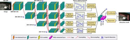
As the optical remote sensing techniques keep developing with a rapid pace, remote sensing images are positively considered in many fields. Accordingly, a great number of algorithms have been exploited for remote sensing image interpretation purposes. Thereinto, object recognition acts as an important ingredient to many applications. However, to achieve highly accurate object recognition is still challengeable caused by the orientation and size diversities, spatial distribution and density variations, shape and aspect ratio irregularities, occlusion and shadow impacts, as well as complex texture and surrounding environment changes. In this paper, a sparse anchoring guided high-resolution capsule network (SAHR-CapsNet) is proposed for geospatial object detection based on remote sensing images. First, formulated with the multibranch high-resolution capsule network architecture assisted by multiscale feature propagation and fusion, the SAHR-CapsNet can extract semantically strong and spatially accurate feature semantics at multiple scales. Second, integrated with the efficient capsule-based self-attention module, the SAHR-CapsNet functions promisingly to attend to target-specific spatial features and informative channel features. Finally, adopted with the capsule-based sparse anchoring network, the SAHR-CapsNet performs efficiently in generating a fixed number of lightweight, high-quality sparse region proposals. Quantitative assessments and comparative analyses on two challenging remote sensing image datasets demonstrate the applicability and effectiveness of the developed SAHR-CapsNet for geospatial object detection applications.
中文翻译:
用于遥感影像地理空间目标检测的稀疏锚定引导高分辨率胶囊网络
随着光学遥感技术的快速发展,遥感图像在许多领域得到了积极的考虑。因此,大量算法已被用于遥感图像解释的目的。其中,对象识别是许多应用程序的重要组成部分。然而,由于方向和尺寸的多样性、空间分布和密度的变化、形状和纵横比的不规则、遮挡和阴影的影响,以及复杂的纹理和周围环境的变化,实现高精度的物体识别仍然具有挑战性。在本文中,提出了一种稀疏锚定引导高分辨率胶囊网络(SAHR-CapsNet),用于基于遥感图像的地理空间目标检测。第一的,SAHR-CapsNet 采用多分支高分辨率胶囊网络架构,辅以多尺度特征传播和融合,可以在多个尺度上提取语义强且空间准确的特征语义。其次,与高效的基于胶囊的自注意力模块相结合,SAHR-CapsNet 有望处理特定目标的空间特征和信息通道特征。最后,采用基于胶囊的稀疏锚定网络,SAHR-CapsNet 在生成固定数量的轻量级、高质量稀疏区域提议方面高效执行。对两个具有挑战性的遥感图像数据集的定量评估和比较分析证明了开发的 SAHR-CapsNet 在地理空间对象检测应用中的适用性和有效性。


 京公网安备 11010802027423号