Science of the Total Environment ( IF 9.8 ) Pub Date : 2021-09-17 , DOI: 10.1016/j.scitotenv.2021.150386 Christian Narvaez-Montoya 1 , Juan Antonio Torres-Martínez 1 , Edwin Pino-Vargas 2 , Fredy Cabrera-Olivera 2 , Frank J Loge 3 , Jürgen Mahlknecht 1
|
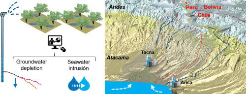
The Caplina/Concordia transboundary coastal aquifer system, located in the Atacama Desert, is the primary source of water supply for domestic use and irrigation for La Yarada-Los Palos (Peru) and Concordia (Chile) agriculture districts, and to a lesser extent, for Tacna province public supply use (Peru). Despite the scarce amount of rainfall (<20 mm/year) in the area and the limited recharge coming from the Andean highlands, this transboundary aquifer system has been overexploited mainly for agriculture since before the 2000s on the Peruvian side. Consequently, this has caused groundwater depletion and seawater intrusion. In this study, comprehensive hydrogeological information was integrated to understand the aquifer system's behavior and the effects to which it has been subjected to groundwater overexploitation. To that end, a 3D hydrogeological framework was developed using the LEAPFROG software and a constant-density groundwater flow model with equivalent heads was generated in FEFLOW software, which was adjusted with Monte Carlo analysis and conventional automated calibration. Finally, eight scenarios, considering various water resource management options proposed by the authority and potential climatic trends (CMIP6), were simulated from 2020 to 2040. The results showed that between 2002 and 2020, the increase in the seawater wedge and the average groundwater level decline were 216 hm3/year and 7 m, respectively. It is expected that the depletion will continue with a groundwater level decline between 5 and 8 m and an increase in the seawater wedge between 1120 hm3/year and 1175 hm3/year for the forecast period. The study concludes that the aquifer system will remain unsustainable for the next 20 years, regardless of the selected scenarios, and suggests that any mitigation measure requires the participation of stakeholders from Peru, Chile, and Bolivia.
中文翻译:
预测阿塔卡马沙漠(秘鲁/智利)跨界沿海含水层系统的不利情景
Caplina/Concordia 跨界沿海含水层系统位于阿塔卡马沙漠,是 La Yarada-Los Palos(秘鲁)和 Concordia(智利)农业区家庭用水和灌溉的主要供水来源,在较小程度上,用于塔克纳省公共供应用途(秘鲁)。尽管该地区降雨量稀少(<20 毫米/年)且来自安第斯高地的补给量有限,但自 2000 年代以来秘鲁一侧的这一跨界含水层系统一直被过度开发,主要用于农业。因此,这导致了地下水枯竭和海水入侵。在这项研究中,综合了全面的水文地质信息,以了解含水层系统的行为及其受到地下水过度开发的影响。为此,使用 LEAPFROG 软件开发了 3D 水文地质框架,并在 FEFLOW 软件中生成了具有等效水头的恒定密度地下水流模型,并通过蒙特卡罗分析和常规自动校准进行了调整。最后,考虑当局提出的各种水资源管理方案和潜在气候趋势(CMIP6),模拟了 2020 年至 2040 年的 8 种情景。结果表明,2002 年至 2020下降为 216 小时3 /年和7 m,分别。预计在预测期内,随着地下水位下降 5 至 8 m,海水楔形增加 1120 hm 3 /年至 1175 hm 3 /年,枯竭将继续。该研究得出的结论是,无论选择何种情景,含水层系统在未来 20 年都将不可持续,并建议任何缓解措施都需要秘鲁、智利和玻利维亚的利益相关者参与。


 京公网安备 11010802027423号