Journal of Hydrology ( IF 5.9 ) Pub Date : 2021-09-03 , DOI: 10.1016/j.jhydrol.2021.126894 K.J. Hokanson 1 , C. Thompson 2 , K. Devito 3 , C.A. Mendoza 1
|
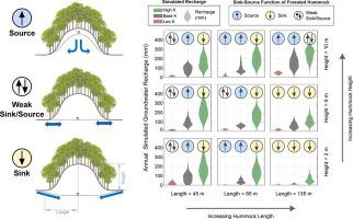
We use two-dimensional numerical models to identify controls on groundwater recharge, water table dynamics, and the sink-source function of fine-textured hummocks in water-limited environments. A silty clay loam hummock with aspen forest cover in the sub-humid Boreal Plains region of Canada is used to develop a conceptual model and calibrate a variably-saturated flow model to better investigate the dynamics of recharge, water table position, and lateral flow between the forested hummock and adjacent peatland. Scenario testing (achieved by raising and lowering the hydraulic conductivity by an order of magnitude and altering the hummock height and length) provides further understanding of the controls that hydraulic conductivity and hummock morphometry exert on recharge and forestland-peatland interactions. We find that the hydraulic conductivity of the glacial till has the largest control over recharge, followed by the hummock height and length and, lastly, annual atmospheric fluxes. Hummocks with higher hydraulic conductivity or long morphometric profiles are most often sinks of water as they promote increased root-water uptake, while taller hummocks with lower hydraulic conductivity tend to act as hydrologic sources for adjacent wetlands. The magnitude of annual recharge and water table elevation are poorly correlated with annual atmospheric fluxes due to the strong effects of multi-year storage deficits or surpluses; however, they are appreciably affected by decadal wet-dry cycles typical of the Boreal Plains climate. Additionally, we show that both distance along a hummock and elevation are key factors in controlling the spatial distribution of recharge at a single hummock. It is common to conceptualize the water table as a shallow and subdued replica of surface topography, where water flows from topographic highs (i.e., forestlands) to topographic lows (i.e., peatlands) in humid environments; however, as we show here, recharge rates, water table elevation, and the sink-source function of a forested hummock in water-limited environments is highly variable in time and space, and strongly dependent on both the hydrogeological and morphometric properties of the hummock.
中文翻译:
丘陵规模对地下水补给率的控制以及在水资源有限的环境中开发当地地下水流系统的潜力
我们使用二维数值模型来确定对地下水补给、地下水位动态和限水环境中细纹理小丘的汇源函数的控制。加拿大半湿润北方平原地区的一个具有白杨林覆盖的粉质粘土小丘被用来开发概念模型并校准可变饱和流模型,以更好地研究补给、地下水位位置和横向流之间的动态森林覆盖的小丘和邻近的泥炭地。情景测试(通过将水力传导率提高和降低一个数量级并改变小丘高度和长度来实现)进一步了解水力传导率和小丘形态测量对补给和林地-泥炭地相互作用的控制。我们发现冰川的水力传导率对补给有最大的控制,其次是小丘的高度和长度,最后是年大气通量。具有较高导水率或长形态测量剖面的小丘通常是水汇,因为它们促进了根部吸水量的增加,而较高的具有较低导水率的小丘往往充当相邻湿地的水文来源。由于多年储存赤字或盈余的强烈影响,年补给量和地下水位升高的幅度与年大气通量的相关性很差;然而,它们明显受到北方平原气候典型的十年干湿循环的影响。此外,我们表明,沿着小丘的距离和海拔都是控制单个小丘补给空间分布的关键因素。通常将地下水位概念化为地表地形的一个浅而柔和的复制品,在潮湿环境中,水从地形高处(即林地)流向地形低处(即泥炭地);然而,正如我们在此展示的,在限水环境中森林小丘的补给率、地下水位海拔和汇源功能在时间和空间上变化很大,并且强烈依赖于小丘的水文地质和形态测量特性. 林地)到潮湿环境中的低地(即泥炭地);然而,正如我们在此展示的,在限水环境中森林小丘的补给率、地下水位海拔和汇源功能在时间和空间上变化很大,并且强烈依赖于小丘的水文地质和形态测量特性. 林地)到潮湿环境中的低地(即泥炭地);然而,正如我们在此展示的,在限水环境中森林小丘的补给率、地下水位海拔和汇源功能在时间和空间上变化很大,并且强烈依赖于小丘的水文地质和形态测量特性.


 京公网安备 11010802027423号