European Journal of Operational Research ( IF 6.0 ) Pub Date : 2021-09-15 , DOI: 10.1016/j.ejor.2021.09.008 Nikolaos A. Kyriakakis 1 , Magdalene Marinaki 1 , Nikolaos Matsatsinis 1 , Yannis Marinakis 1
|
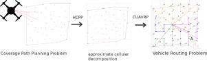
This paper presents a Cumulative Unmanned Aerial Vehicle Routing Problem (CUAVRP) approach to optimize Humanitarian Coverage Path Planning (HCPP). Coverage path planning consists of finding the route which covers every point of a certain area of interest. This paper considers a Search & Rescue mission, using a homogeneous fleet of Unmanned Aerial Vehicles (UAVs). In this scenario, the objective is to minimize the sum of arrival times at all points of the area of interest, thus, completing the search with minimum latency. The HCPP problem is transformed into a Vehicle Routing Problem by using an approximate cellular decomposition technique to discretize the area into a grid, where the rectangles represent the UAV sensor’s field of view. The center points of the formed rectangles, become the nodes used for a UAV routing problem. This approach uses the objective of minimizing the sum of arrival times at customers, found in the Cumulative Capacitated Vehicle Routing Problem (CCVRP), adjusted for the Search & Rescue Coverage Path Planning using UAVs. The Min-max objective is also implemented and tested. Three versions of a Parallel Weighted Greedy Randomized Adaptive Search Procedure - Variable Neighborhood Decent (GRASP-VND) algorithm is implemented to solve the Cumulative UAV Routing Problem for Humanitarian Coverage Path Planning.
中文翻译:
一种用于人道主义覆盖路径规划的累积无人机路径问题方法
本文提出了一种累积无人驾驶飞行器路由问题 (CUAVRP) 方法来优化人道主义覆盖路径规划 (HCPP)。覆盖路径规划包括找到覆盖某个感兴趣区域的每个点的路线。本文考虑了使用同质无人机 (UAV) 机队进行的搜索和救援任务。在这种情况下,目标是最小化感兴趣区域所有点的到达时间总和,从而以最小的延迟完成搜索。通过使用近似细胞分解技术将区域离散化为网格,将 HCPP 问题转换为车辆路由问题,其中矩形代表无人机传感器的视野。形成的矩形的中心点成为用于无人机路由问题的节点。该方法使用的目标是最小化到达客户的时间总和,在累积容量车辆路径问题 (CCVRP) 中发现,并针对使用无人机的搜索和救援覆盖路径规划进行了调整。最小-最大目标也被实施和测试。三个版本的并行加权贪心随机自适应搜索过程 - 可变邻域体面 (GRASP-VND) 算法用于解决人道主义覆盖路径规划的累积无人机路由问题。


 京公网安备 11010802027423号