Atmospheric Environment ( IF 4.2 ) Pub Date : 2021-09-12 , DOI: 10.1016/j.atmosenv.2021.118719 Xiansheng Liu 1, 2, 3 , Hadiatullah Hadiatullah 4, 5 , Xun Zhang 1 , Jürgen Schnelle-Kreis 2 , Xiaohu Zhang 6 , Xiuxiu Lin 7 , Xin Cao 2, 3 , Ralf Zimmermann 2, 3
|
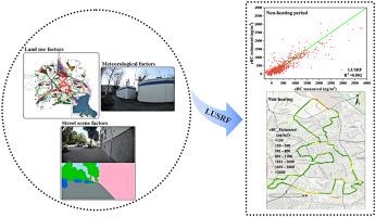
In this study, we developed a novel land-use street view image random forest (LUSRF) model to estimate the equivalent black carbon (eBC) concentration based on land-use random forest (LURF) and street view imagery (SVI) models and compared their accuracy and precision in the urban city of Augsburg, Germany. The variables of the LUSRF model were constructed by combining LURF and SVI model variables (i.e., land-use, street scene, and meteorological factors). Stratified cross-validation (CV) was used to validate the model performance. Based on R2 and IA (Index of Agreement), LUSRF has superiority (average-R2: 0.73, average-IA: 0.91) compared to the LURF (average-R2: 0.52, average-IA: 0.81) and SVI model (average-R2: 0.68, average-IA: 0.89) in the urban city of Augsburg during the observed period. The main driving factors of the LUSRF model for BC estimation were different in heating and non-heating periods (i.e., elevation, the proportion of moving cars, and relative humidity for the non-heating period; and elevation, the proportion of building, and relative humidity for the heating period), which improves the estimation accuracy of eBC concentration and its sources. The model verification in other areas (i.e., suburban and small towns) further proved that the model has certain generalizability. Overall, the LUSRF model will provide insight for epidemiological studies in urban areas as a personal exposure assessment.
中文翻译:
用于估算城市地区黑碳浓度的土地利用和街景图像组合模型
在本研究中,我们开发了一种新的土地利用街景图像随机森林 (LUSRF) 模型,以基于土地利用随机森林 (LURF) 和街景图像 (SVI) 模型来估计等效黑碳 (eBC) 浓度,并进行比较他们在德国奥格斯堡市的准确性和精确度。LUSRF 模型的变量是通过结合LURF 和SVI 模型变量(即土地利用、街道场景和气象因素)构建的。分层交叉验证(CV)用于验证模型性能。基于R 2和IA(一致性指数),LUSRF与LURF(average-R 2:0.52,average-IA:0.81)和SVI 模型相比,具有优势(average-R 2:0.73,average-IA:0.91)(平均-R 2: 0.68, 平均-IA: 0.89) 在观察期间的奥格斯堡市区。LUSRF模型用于BC估计的主要驱动因素在供暖期和非供暖期(即海拔、移动汽车的比例和非供暖期的相对湿度;以及海拔、建筑物的比例和相对湿度),提高了 eBC 浓度及其来源的估计精度。在其他地区(即郊区和小城镇)的模型验证进一步证明了该模型具有一定的泛化性。总体而言,LUSRF 模型将为城市地区的流行病学研究作为个人暴露评估提供见解。


 京公网安备 11010802027423号