当前位置:
X-MOL 学术
›
Environ. Sci. Technol.
›
论文详情
Our official English website, www.x-mol.net, welcomes your
feedback! (Note: you will need to create a separate account there.)
Predicting Within-City Spatial Variations in Outdoor Ultrafine Particle and Black Carbon Concentrations in Bucaramanga, Colombia: A Hybrid Approach Using Open-Source Geographic Data and Digital Images
Environmental Science & Technology ( IF 10.8 ) Pub Date : 2021-09-09 , DOI: 10.1021/acs.est.1c01412 Marshall Lloyd 1 , Ellison Carter 2 , Florencio Guzman Diaz 2 , Kento Taro Magara-Gomez 3 , Kris Y Hong 1 , Jill Baumgartner 1, 4 , Víctor M Herrera G 5 , Scott Weichenthal 1
Environmental Science & Technology ( IF 10.8 ) Pub Date : 2021-09-09 , DOI: 10.1021/acs.est.1c01412 Marshall Lloyd 1 , Ellison Carter 2 , Florencio Guzman Diaz 2 , Kento Taro Magara-Gomez 3 , Kris Y Hong 1 , Jill Baumgartner 1, 4 , Víctor M Herrera G 5 , Scott Weichenthal 1
Affiliation
|
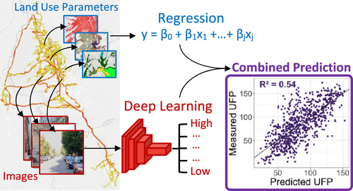
Outdoor ultrafine particles (UFP, <0.1 μm) and black carbon (BC) vary greatly within cities and may have adverse impacts on human health. In this study, we used a hybrid approach to develop new models to estimate within-city spatial variations in outdoor UFP and BC concentrations across Bucaramanga, Colombia. We conducted a mobile monitoring campaign over 20 days in 2019. Regression models were trained on land use data and combined with predictions from convolutional neural networks (CNN) trained to predict UFP and BC concentrations using satellite and street-level images. The combined UFP model (R2 = 0.54) outperformed the CNN (R2 = 0.47) and land use regression (LUR) models (R2 = 0.47) on their own. Similarly, the combined BC model also outperformed the CNN and LUR BC models (R2 = 0.51 vs 0.43 and 0.45, respectively). Spatial variations in model performance were more stable for the CNN and combined models compared to the LUR models, suggesting that the combined approach may be less likely to contribute to differential exposure measurement error in epidemiological studies. In general, our findings demonstrated that satellite and street-level images can be combined with a traditional LUR modeling approach to improve predictions of within-city spatial variations in outdoor UFP and BC concentrations.
中文翻译:

预测哥伦比亚布卡拉曼加室外超细颗粒和黑碳浓度的城市内空间变化:使用开源地理数据和数字图像的混合方法
室外超细颗粒物(UFP,<0.1 μm)和黑碳(BC)在城市内差异很大,可能对人体健康产生不利影响。在这项研究中,我们使用混合方法来开发新模型,以估计哥伦比亚布卡拉曼加的室外 UFP 和 BC 浓度的城市内空间变化。我们在 2019 年开展了超过 20 天的移动监测活动。回归模型在土地利用数据上进行了训练,并结合了卷积神经网络 (CNN) 的预测,该网络训练使用卫星和街道级图像来预测 UFP 和 BC 浓度。组合的 UFP 模型 ( R 2 = 0.54) 优于 CNN ( R 2 = 0.47) 和土地利用回归 (LUR) 模型 ( R 2= 0.47)。同样,组合的 BC 模型也优于 CNN 和 LUR BC 模型(R 2 = 0.51,分别为 0.43 和 0.45)。与 LUR 模型相比,CNN 和组合模型的模型性能的空间变化更稳定,这表明组合方法可能不太可能导致流行病学研究中的差异暴露测量误差。总的来说,我们的研究结果表明,卫星和街道级图像可以与传统的 LUR 建模方法相结合,以改进对室外 UFP 和 BC 浓度的城市内空间变化的预测。
更新日期:2021-09-21
中文翻译:
预测哥伦比亚布卡拉曼加室外超细颗粒和黑碳浓度的城市内空间变化:使用开源地理数据和数字图像的混合方法
室外超细颗粒物(UFP,<0.1 μm)和黑碳(BC)在城市内差异很大,可能对人体健康产生不利影响。在这项研究中,我们使用混合方法来开发新模型,以估计哥伦比亚布卡拉曼加的室外 UFP 和 BC 浓度的城市内空间变化。我们在 2019 年开展了超过 20 天的移动监测活动。回归模型在土地利用数据上进行了训练,并结合了卷积神经网络 (CNN) 的预测,该网络训练使用卫星和街道级图像来预测 UFP 和 BC 浓度。组合的 UFP 模型 ( R 2 = 0.54) 优于 CNN ( R 2 = 0.47) 和土地利用回归 (LUR) 模型 ( R 2= 0.47)。同样,组合的 BC 模型也优于 CNN 和 LUR BC 模型(R 2 = 0.51,分别为 0.43 和 0.45)。与 LUR 模型相比,CNN 和组合模型的模型性能的空间变化更稳定,这表明组合方法可能不太可能导致流行病学研究中的差异暴露测量误差。总的来说,我们的研究结果表明,卫星和街道级图像可以与传统的 LUR 建模方法相结合,以改进对室外 UFP 和 BC 浓度的城市内空间变化的预测。


 京公网安备 11010802027423号