Journal of Hydrology ( IF 5.9 ) Pub Date : 2021-09-04 , DOI: 10.1016/j.jhydrol.2021.126898 Roland Löwe 1 , Julian Böhm 1, 2 , David Getreuer Jensen 3 , Jorge Leandro 4 , Søren Højmark Rasmussen 3
|
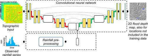
This study investigates how deep-learning can be configured to optimise the prediction of 2D maximum water depth maps in urban pluvial flood events. A neural network model is trained to exploit patterns in hyetographs as well as in topographical data, with the specific aim of enabling fast predictions of flood depths for observed rain events and spatial locations that have not been included in the training dataset. A neural network architecture that is widely used for image segmentation (U-NET) is adapted for this purpose. Key novelties are a systematic investigation of which spatial inputs should be provided to the deep learning model, which hyper-parametrization optimizes predictive performance, and a systematic evaluation of prediction performance for locations and rain events that were not considered in training. We find that a spatial input dataset of only 5 variables that describe local terrain shape and imperviousness is optimal to generate predictions of water depth. Neural network architectures with between 97,000 and 260,000,000 parameters are tested, and a model with 28,000,000 parameters is found optimal. U-FLOOD is demonstrated to yield similar predictive performance as existing screening approaches, even though the assessment is performed for natural rain events and in locations unknown to the network, and flood predictions are generated within seconds. Improvements can likely be obtained by ensuring a balanced representation of temporal and spatial rainfall patterns in the training dataset, further improved spatial input datasets, and by linking U-FLOOD to dynamic sewer system models.
中文翻译:
U-FLOOD – 用于预测城市洪水洪水深度的地形深度学习
本研究调查了如何配置深度学习以优化城市洪涝事件中二维最大水深图的预测。训练神经网络模型以利用水文图和地形数据中的模式,其具体目标是能够快速预测未包含在训练数据集中的观测降雨事件和空间位置的洪水深度。广泛用于图像分割 (U-NET) 的神经网络架构适用于此目的。关键的创新是系统调查应向深度学习模型提供哪些空间输入,哪些超参数化可优化预测性能,以及对训练中未考虑的位置和降雨事件的预测性能进行系统评估。我们发现只有 5 个变量的空间输入数据集描述了局部地形形状和不透水性,是生成水深预测的最佳选择。测试了具有 97,000 到 260,000,000 个参数的神经网络架构,并发现具有 28,000,000 个参数的模型是最佳的。U-FLOOD 被证明可以产生与现有筛选方法类似的预测性能,即使评估是针对自然降雨事件和网络未知的位置进行的,并且洪水预测是在几秒钟内生成的。通过确保训练数据集中时空降雨模式的平衡表示、进一步改进空间输入数据集以及将 U-FLOOD 与动态下水道系统模型联系起来,可能会获得改进。


 京公网安备 11010802027423号