Ore Geology Reviews ( IF 3.2 ) Pub Date : 2021-09-01 , DOI: 10.1016/j.oregeorev.2021.104452 Sajjad Talesh Hosseini 1 , Omid Asghari 1 , Xavier Emery 2, 3
|
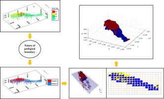
A critical challenge in evaluating mineral resources is to model the uncertainty of geological boundaries and to classify the block model into domains of similar rock or ore types. The aim of this study is to deal with the problem of simulating geological boundaries in the Golgohar iron deposit based on two datasets extracted from exploration boreholes and blast holes. In the first step, contact analysis tools are used to identify the nature of geological boundaries. Next, a modified version of the direct sampling algorithm is proposed to simulate geological domains based on a training image and local probabilities derived from a vertical proportion matrix. The purpose of using the modified direct sampling is to control the local proportion of each geological domain in the distance-based multiple-point geostatistical approaches. A set of 100 conditional realizations of two ore types are generated. The reconciliation between the realizations produced with the proposed algorithm and actual data values is provided by checking the reproduction of single-, two- and multiple-point statistical parameters and the connectivity of geological boundaries. The proposed method proves to be a useful variant of the direct sampling algorithm for simulating the spatial layout of geological domains when there is a strong difference in the domain proportions between the hard data and the TI.
中文翻译:
一种增强的直接采样 (DS) 方法来模拟具有局部不同比例的地质域:应用于伊朗 Golgohar 铁矿
评估矿产资源的一个关键挑战是对地质边界的不确定性进行建模,并将区块模型分类为类似岩石或矿石类型的域。本研究的目的是基于从勘探钻孔和爆破孔中提取的两个数据集来处理模拟 Golgohar 铁矿床地质边界的问题。第一步,使用接触分析工具识别地质边界的性质。接下来,提出了直接采样算法的修改版本,以基于训练图像和从垂直比例矩阵导出的局部概率来模拟地质域。使用改进的直接采样的目的是在基于距离的多点地质统计方法中控制每个地质域的局部比例。生成了一组 100 个两种矿石类型的条件实现。通过检查单点、两点和多点统计参数的再现以及地质边界的连通性,提供了使用所提出的算法产生的实现与实际数据值之间的协调。当硬数据和TI之间的域比例存在很大差异时,所提出的方法被证明是模拟地质域空间布局的直接采样算法的有用变体。


 京公网安备 11010802027423号