Agricultural Systems ( IF 6.1 ) Pub Date : 2021-08-31 , DOI: 10.1016/j.agsy.2021.103264 José Eduardo Holler Branco 1 , Daniela Bacchi Bartholomeu 1 , Paulo Nocera Alves Junior 1 , José Vicente Caixeta Filho 1
|
CONTEXT
Given the need to expand food production to satisfy an increasing world population; regional land-use planners must direct this expansion to available, permitted areas (i.e., not legally protected forests) where production can be maximized and transportation costs, production costs and environmental impacts can be minimized. In this balancing act, the capabilities and layout of the current and future transport system are crucial in determining the spatial distribution of future agricultural production.
OBJECTIVE
The objective of the present study was to develop a modeling framework to determine the optimal spatial distribution of new soybean and corn production areas in Brazil and transport flows needed to move these commodities to maximize economic gains and limit or reduce negative environmental impacts.
METHODS
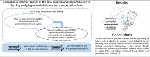
Initially, we applied Data Envelopment Analysis (DEA) to classify regions suitable for expanding soybean and corn production according to an area's potential for superior agricultural performance. Subsequently, we used a Network Equilibrium Model (NEM) to determine the best spatial distribution of new soybean and corn production areas so that their production added to existing production meets the estimated 2050 demand and the optimal configuration of existing and proposed transportation infrastructure required to move this production to appropriate locations.
RESULTS AND CONCLUSIONS
When compared to a 2018 baseline, the complete operation of planned railroads and the positioning of future grain production to occupy regions indicated by the modeling could increase soybean and corn production by 66% without simultaneous deforestation, reduce carbon dioxide emissions due to interregional soybean and corn transport by about 14%, and reduce combined transport and production costs by about 2%.
SIGNIFICANCE
The proposed modeling framework should be an extremely useful tool when determining sites for future agriculture production and the network matrix needed to transport this production, especially when considering the relationship between land use and transportation infrastructure.
中文翻译:
农业土地利用和运输网络的相互分析:巴西大豆和玉米生产的未来位置。
语境
鉴于需要扩大粮食生产以满足不断增长的世界人口;区域土地使用规划者必须将这种扩展引导到可用的、允许的区域(即不受法律保护的森林),在这些区域可以最大限度地提高产量,并最大限度地降低运输成本、生产成本和环境影响。在这种平衡行为中,当前和未来交通系统的能力和布局对于决定未来农业生产的空间分布至关重要。
客观的
本研究的目的是开发一个建模框架,以确定巴西新大豆和玉米产区的最佳空间分布以及运输这些商品所需的运输流量,以最大限度地提高经济收益并限制或减少负面环境影响。
方法
最初,我们应用数据包络分析 (DEA) 来根据一个地区的卓越农业绩效潜力对适合扩大大豆和玉米生产的地区进行分类。随后,我们使用网络均衡模型 (NEM) 来确定新大豆和玉米产区的最佳空间分布,以便在现有生产中增加的产量满足估计的 2050 年需求以及现有和拟定运输基础设施的最佳配置。这个生产到适当的地点。
结果和结论
与 2018 年基线相比,规划铁路的完整运营以及未来粮食生产定位于模型指示的区域,可以将大豆和玉米产量增加 66%,而不会同时砍伐森林,减少区域间大豆和玉米的二氧化碳排放量运输成本降低约 14%,联运和生产成本降低约 2%。
意义
在确定未来农业生产的地点和运输这种生产所需的网络矩阵时,特别是在考虑土地利用和运输基础设施之间的关系时,提议的建模框架应该是一个非常有用的工具。


 京公网安备 11010802027423号