Agricultural and Forest Meteorology ( IF 5.6 ) Pub Date : 2021-08-28 , DOI: 10.1016/j.agrformet.2021.108622 Dhahi Al-Shammari 1 , Brett M. Whelan 1 , Chen Wang 2 , Robert G.V. Bramley 3 , Mario Fajardo 1 , Thomas F.A. Bishop 1
|
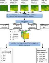
Data-driven approaches hold great promise for better understanding of within-field crop yield variability. Data-driven models use spatiotemporal information that relate to plant growth and can be correlated with yield. Such data is available at different spatial resolutions so a decision is needed about what spatial resolution we should model at which can be determined based on the required management resolution; however, this does not always match the resolution of the input data. Prediction quality can change with spatial resolution. Therefore, this work focused on exploring changes in prediction quality with changes in the spatial resolution of predictors and the predictions. More specifically, this study investigated whether inputs should be resampled prior to modeling or the modeling implemented first with aggregation of predictions happening as a final step. The study consisted of 59 fields over six years in the south-west region of Australia. Rainfed canola, barley and wheat were used for this study. Data used for modeling were acquired from different sources. These data consisted of interpolated yield monitor data and soil sensor data, Landsat 8 data, elevation data, digital soil maps, and weather data. The first approach was based on resampling the inputs to four spatial resolutions (10, 30, 90 m and whole-field-average). The second approach was based on aggregating the outputs from the models which were built at 10, 30 and 90 m to the coarser resolutions and eventually to the whole-field-average. This study showed that the second approach (modeling at the highest resolution and aggregating the outputs to the whole field average) resulted in the highest Lin's Concordance Correlation Coefficient (LCCC) (0.87) and lowest RMSE (0.59 t ha−1). This study confirmed that better results can be obtained from machine learning models by following the appropriate approach to related to the spatial resolution resampling.
中文翻译:
空间分辨率对特定地点作物管理的作物产量预测质量的影响
数据驱动的方法有望更好地了解田间作物产量的变异性。数据驱动模型使用与植物生长相关的时空信息,并且可以与产量相关。这些数据在不同的空间分辨率下可用,因此需要决定我们应该建模的空间分辨率,可以根据所需的管理分辨率确定;然而,这并不总是与输入数据的分辨率相匹配。预测质量会随着空间分辨率而变化。因此,这项工作的重点是探索预测质量随着预测变量和预测的空间分辨率的变化而发生的变化。进一步来说,这项研究调查了是否应该在建模之前对输入进行重新采样,或者首先实施建模并将预测聚合作为最后一步。该研究包括澳大利亚西南部地区六年内的 59 个油田。本研究使用雨养油菜、大麦和小麦。用于建模的数据是从不同来源获得的。这些数据包括内插产量监测数据和土壤传感器数据、Landsat 8 数据、高程数据、数字土壤图和天气数据。第一种方法基于将输入重新采样为四种空间分辨率(10、30、90 m 和全场平均)。第二种方法基于将在 10、30 和 90 m 处构建的模型的输出聚合为较粗的分辨率,并最终聚合为全场平均。-1 )。该研究证实,通过遵循与空间分辨率重采样相关的适当方法,可以从机器学习模型中获得更好的结果。


 京公网安备 11010802027423号