Geoscience Frontiers ( IF 8.5 ) Pub Date : 2021-08-25 , DOI: 10.1016/j.gsf.2021.101290 Purushottam Kumar Garg 1, 2 , Jairam Singh Yadav 2 , Santosh Kumar Rai 2 , Aparna Shukla 2, 3
|
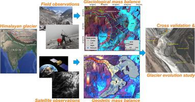
Glaciological mass balance (MB) is considered the most direct, undelayed and unfiltered response of the glaciers to climatic perturbations. However, it may inherit errors associated with stake under-representation, averaging over the entire glacier and human bias. Therefore, proper validation of glaciological MB with geodetic MB is highly recommended by the World Glacier Monitoring Service (WGMS). The present study focuses on the Dokriani Glacier, central Himalaya which is one of the bench-mark glaciers in the region and has glaciological MB records from 1993 to 2013 with intermittent gaps. In the present study, firstly the glaciological MB series is extended to 2014 i.e., field-based MB for one more year is computed and, to compare with it, the geodetic MB is computed for the 1999–2014 period using high resolution Cartosat-1 digital elevation model (DEM) and SRTM DEM. Finally, the study assesses the regional representation of the Dokriani Glacier in terms of MB and evaluates the influence of the MB regime on its morphological evolution. Results show that the average glaciological MB (−0.34 ± 0.2 m water equivalent (w.e.) y−1) is more negative than the geodetic MB (−0.23 ± 0.1 m w.e. y−1) for the 1999–2014 period. This is likely because of the partial representation of glacier margins in the glaciological MB, where melting is strikingly low owing to thick debris cover (>30 cm). In contrast, geodetic MB considers all marginal pixels leading to a comparatively low MB. A comparative assessment shows that the MB of Dokriani Glacier is less negative (possibly due to its huge accumulation area) than most other glacier-specific and regional MBs, restricting it to be a representative glacier in the region. Moreover, continuous negative MB has brought a peculiar change in the epiglacial morphology in the lower tongue of the glacier as differential debris thickness-induced differential melting has turned the glacier surface into a concave one. This concavity has led to development of a large (10–20 m deep) supraglacial channel which is expanding incessantly. The supraglacial channel is also connected with the snout wall and accelerates terminus disintegration. Given the total thickness of about 30–50 m in the lower glacier tongue, downwasting at its current pace, deepening/widening of supraglacial channel coupled with rapid terminus retreat may lead to the complete vanishing of the lower one km glacier tongue.
中文翻译:
1999-2014 年印度喜马拉雅中部 Dokriani 冰川的物质平衡和形态演化
冰川质量平衡 (MB) 被认为是冰川对气候扰动的最直接、未延迟和未过滤的响应。然而,它可能会继承与权益代表不足相关的错误,平均整个冰川和人类偏见。因此,世界冰川监测服务 (WGMS) 强烈建议使用大地测量 MB 对冰川 MB 进行正确验证。本研究的重点是喜马拉雅中部的 Dokriani 冰川,它是该地区的标志性冰川之一,从 1993 年到 2013 年有间歇性的冰川 MB 记录。在本研究中,首先将冰川学 MB 系列扩展到 2014 年,即计算一年的基于现场的 MB,并与之进行比较,使用高分辨率 Cartosat-1 数字高程模型 (DEM) 和 SRTM DEM 计算 1999-2014 年期间的大地测量 MB。最后,该研究评估了多克里亚尼冰川在 MB 方面的区域代表性,并评估了 MB 制度对其形态演变的影响。结果表明,平均冰川 MB (-0.34 ± 0.2 m 水当量 (we) y−1 ) 比大地测量 MB (−0.23 ± 0.1 m we y −1) 1999-2014 年期间。这可能是因为冰川学 MB 中冰川边缘的部分代表,由于厚厚的碎片覆盖(> 30 cm),融化程度非常低。相比之下,大地测量 MB 会考虑所有边缘像素,导致 MB 相对较低。比较评估表明,多克里亚尼冰川的 MB 比大多数其他特定冰川和区域 MB 的负值较小(可能是由于其巨大的堆积面积),使其成为该地区的代表性冰川。此外,连续的负 MB 使冰川下舌的冰缘形态发生了奇特的变化,因为不同的碎片厚度引起的差异融化使冰川表面变成了凹面。这种凹陷导致了一个大型(10-20 m 深)冰上通道的发展,该通道不断扩大。冰上通道还与口鼻壁相连,加速末端解体。鉴于下部冰川舌总厚度约为 30-50 m,以目前的速度下降,冰川上通道加深/加宽,加上终点快速后退,可能导致下部 1 km 冰川舌完全消失。


 京公网安备 11010802027423号