Catena ( IF 5.4 ) Pub Date : 2021-08-23 , DOI: 10.1016/j.catena.2021.105660 Alberto J. Alaniz 1, 2, 3 , Ana M. Abarzúa 4 , Alejandra Martel-Cea 4 , Leonora Jarpa 4 , Marjorie Hernández 4 , Marco A. Aquino-López 5 , Cecilia Smith-Ramírez 6, 7, 8
|
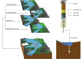
Soil loss has become one of the main problems associated with global change over the last decades. New assessments are needed in order to improve our understanding of the real impacts of human productive activities on the natural dynamics linked to erosion in lake basins. We analyzed the recent and historical dynamics of soil loss in a coastal lake basin of central Chile (Lanalhue lake), evaluating land use impacts and proposing management changes to control erosion and restore the soil. We implemented two approaches: A) Using a high-resolution sedimentological proxy and a high-accuracy chronology of cores to determine the sediment accumulation rate, organic/inorganic matter and granulometry for the last 120 years; and B) applying the Universal Soil Loss Equation to estimate erosion of soil from hills during the last 32 years, considering a combination of satellite, climate, soil, and land-cover topographic data. We found that the sedimentation rates, as well as the concentration of organic matter in lake sediments, were relatively constant from 1900 to 1950; after that, they experienced a significant increase. The same pattern of rapid increase was found for sand content. We found that erosion during the last 30 years has been high and constant, especially in bare soil (mainly clear-cutting areas) and exotic forest plantations. Erosion has been significantly higher within exotic forest plantations, reaching 31 ton/ha/yr in clear-cutting areas. Three industrial forestry companies accounted for 61.5% of the basin surface where urgent erosion control is needed. Our findings support the indication that industrial forestry is the main activity affecting erosion dynamics in the basin; secondarily, earthquakes have been important modulators of the sediment dynamics in Lanalhue during these last 120 years.
中文翻译:
将沉积学和空间分析联系起来以评估林业对土壤流失的影响:以智利拉纳尔胡盆地为例
在过去的几十年里,土壤流失已成为与全球变化相关的主要问题之一。需要进行新的评估,以提高我们对人类生产活动对与湖盆侵蚀相关的自然动态的真正影响的理解。我们分析了智利中部沿海湖盆(拉纳尔胡湖)土壤流失的近期和历史动态,评估了土地利用影响并提出了管理变革以控制侵蚀和恢复土壤。我们采用了两种方法:A) 使用高分辨率沉积学代理和高精度岩心年表来确定过去 120 年的沉积物积累率、有机/无机物质和粒度;B) 应用通用土壤流失方程来估计过去 32 年中山地土壤侵蚀,综合考虑卫星、气候、土壤和土地覆盖地形数据。我们发现,1900 年至 1950 年,湖泊沉积物的沉积速率以及有机质浓度相对恒定;在那之后,他们经历了显着的增长。砂含量也发现了同样的快速增加模式。我们发现,过去 30 年的侵蚀一直很高而且持续,尤其是在裸露的土壤(主要是砍伐地区)和外来森林种植园中。外来森林人工林的侵蚀量明显更高,在砍伐地区达到 31 吨/公顷/年。三个工业林业公司占流域面积的 61.5%,需要紧急控制侵蚀。我们的研究结果支持工业林业是影响流域侵蚀动态的主要活动的迹象;其次,在过去的 120 年里,地震一直是拉纳尔胡埃沉积物动力学的重要调节器。


 京公网安备 11010802027423号