Remote Sensing of Environment ( IF 11.1 ) Pub Date : 2021-08-13 , DOI: 10.1016/j.rse.2021.112634 Jan Jelének 1 , Veronika Kopačková-Strnadová 1
|
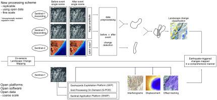
Earthquakes can trigger numerous landslides and cause other significant changes in the landscape over large areas. This study presents a new processing scheme combining radar (Copernicus Sentinel-1) and optical satellite data (Copernicus Sentinel-2) to quickly and easily map landscape changes such as landslides, coastal uplift and changes in water bodies caused by a severe event such as an earthquake. The processing scheme has been tested for the 2016 Kaikoura earthquake (Mw 7.8), New Zealand, which impacted vast and mostly inaccessible areas, causing hundreds of landslides. The workflow combines the following change-detection methods: i) Sentinel-1 amplitude change detection ii) Sentinel-2-based detection of non-vegetated areas that occurred after the event using the atmospherically resistant vegetation index (ARVI). To get a more complex view of the surface changes caused by the Kaikoura earthquake, the available online services and tools were further tested (open source via the European Space Agency) allowing automatic detection of vertical displacements and deformations. It was concluded, that the above-mentioned approaches facilitated the assessment of earthquake-triggered changes in a comprehensive manner. The methodology is an example of how to detect earthquake landscape changes in an automatic and rapid manner. The new processing scheme for the synergic use of Sentinel-1 and Sentinel-2 data has high potential to be used for operational and scientific purposes, since it relies on globally available, free data and provides high spatial and temporal resolution. The results can be obtained and made available only a few days after an event, therefore providing significant insights into earthquake impact assessment and may also be helpful for prioritizing field work.
中文翻译:
协同使用 Sentinel-1 和 Sentinel-2 数据自动检测地震触发的景观变化:2016 年新西兰凯库拉地震 (Mw 7.8) 的案例研究
地震会引发大量山体滑坡,并导致大面积景观发生其他重大变化。本研究提出了一种结合雷达 (Copernicus Sentinel-1) 和光学卫星数据 (Copernicus Sentinel-2) 的新处理方案,以快速轻松地绘制山体滑坡、沿海隆起等严重事件引起的水体变化等景观变化图,例如地震。该处理方案已经针对 2016 年新西兰凯库拉地震 (Mw 7.8) 进行了测试,该地震影响了广大且大多无法进入的地区,造成了数百次山体滑坡。该工作流程结合了以下变化检测方法:i) Sentinel-1 振幅变化检测 ii) 基于 Sentinel-2 的使用大气抗性植被指数 (ARVI) 检测事件发生后发生的非植被区域。为了更复杂地了解凯库拉地震引起的地表变化,进一步测试了可用的在线服务和工具(通过欧洲航天局开源),允许自动检测垂直位移和变形。结论是,上述方法有助于综合评估地震引发的变化。该方法是如何以自动和快速的方式检测地震景观变化的一个例子。用于协同使用 Sentinel-1 和 Sentinel-2 数据的新处理方案具有用于操作和科学目的的巨大潜力,因为它依赖于全球可用的免费数据并提供高空间和时间分辨率。结果可以在事件发生后几天内获得并提供,


 京公网安备 11010802027423号