Marine Chemistry ( IF 3.0 ) Pub Date : 2021-08-12 , DOI: 10.1016/j.marchem.2021.104020 Ciro Cataneo Liutti 1, 2, 3 , Rodrigo Kerr 1, 2, 3 , Thiago Monteiro 1, 2, 3 , Iole Beatriz Marques Orselli 1, 2, 3 , Rosane Gonçalves Ito 2, 4 , Carlos Alberto Eiras Garcia 1, 3
|
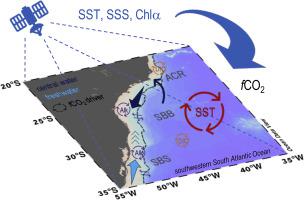
The South Atlantic Ocean is historically less sampled than the North Atlantic Ocean. Recent efforts have improved our understanding of the carbonate system variable distribution, mainly on sea surface CO2 fugacity (fCO2). However, these studies have been regionally and temporally restricted. Hence, in this research we developed seasonal algorithms of sea surface fCO2 to investigate the CO2 dynamics along the southwestern South Atlantic Ocean during spring-summer and fall-winter periods. The studied region includes the continental shelf areas of the Abrolhos-Campos Region (an area under the influence of central water upwelling), the South Brazil Bight (a large embayment affected by the mesoscale variability in a westward boundary current), the Southern Brazilian Shelf (a coastal zone influenced by freshwater discharge from continent and water mass entrainment), and offshore waters in the open ocean domain of the southwestern South Atlantic Ocean. Monthly satellite images of sea surface temperature, salinity, and chlorophyll-a, which were concomitantly available from August 2011 to June 2015, were used to reconstruct and evaluate the sea surface fCO2 seasonal field. The predicted fields of sea surface fCO2 enabled an investigation of the main drivers that change this variable over the distinct biogeochemical provinces in the region. As expected, the sea surface temperature was the main driver of seasonal changes in sea surface fCO2, but total dissolved inorganic carbon (DIC) and total alkalinity changes were also relevant, mainly in the biogeochemical provinces under the influence of continental freshwater input or central water upwelling. The latter can play an unpredictable role in CO2 dynamics due to nutrient- and DIC-rich water transport close to the surface. Finally, the use of satellite-derived images is a powerful tool to increase biogeochemical knowledge of relatively undersampled ocean regions, while the development of seasonal sea surface fCO2 algorithms allows a better spatiotemporal comprehension of the CO2 distribution, dynamics, and drivers in the southwestern South Atlantic Ocean – a key region for improving the understanding of the global carbon cycle.
中文翻译:
南大西洋西南部海面二氧化碳逸度:基于卫星图像的评估
从历史上看,南大西洋的采样率低于北大西洋。最近的努力提高了我们对碳酸盐系统变量分布的理解,主要是在海面 CO 2逸度 ( f CO 2 ) 上。然而,这些研究受到地域和时间的限制。因此,在这项研究中,我们开发了海面f CO 2 的季节性算法来研究 CO 2春夏秋冬期间南大西洋西南部的动态变化。研究区域包括阿布洛霍斯-坎波斯地区的大陆架地区(受中央上升流影响的地区)、南巴西湾(受西边界流中尺度变化影响的大型海湾)、南巴西陆架(受大陆淡水排放和水团夹带影响的沿海地区)和南大西洋西南部公海领域的近海水域。2011 年 8 月至 2015 年 6 月期间同时提供的海面温度、盐度和叶绿素a 的月度卫星图像用于重建和评估海面f CO2季节性领域。海面f CO 2的预测场使我们能够调查在该地区不同的生物地球化学省份上改变这个变量的主要驱动因素。正如预期的那样,海面温度是海面f CO 2季节性变化的主要驱动因素,但总溶解无机碳(DIC)和总碱度变化也有相关性,主要是在大陆淡水输入影响下的生物地球化学省份或中央上涌水。后者可以在 CO 2 中发挥不可预测的作用由于靠近地表的富含营养物质和 DIC 的水运输引起的动力学。最后,卫星图像的使用是增加对相对欠采样海洋区域的生物地球化学知识的有力工具,而季节性海面f CO 2算法的发展可以更好地了解 CO 2分布、动力学和驱动因素。南大西洋西南部——提高对全球碳循环认识的关键区域。


 京公网安备 11010802027423号