当前位置:
X-MOL 学术
›
Remote Sens. Ecol. Conserv.
›
论文详情
Our official English website, www.x-mol.net, welcomes your
feedback! (Note: you will need to create a separate account there.)
Quantifying the causes and consequences of variation in satellite-derived population indices: a case study of emperor penguins
Remote Sensing in Ecology and Conservation ( IF 3.9 ) Pub Date : 2021-08-11 , DOI: 10.1002/rse2.233 Sara Labrousse 1, 2 , David Iles 2, 3 , Lise Viollat 2 , Peter Fretwell 4 , Philip N. Trathan 4 , Daniel P. Zitterbart 2, 5 , Stephanie Jenouvrier 2 , Michelle LaRue 1, 6
Remote Sensing in Ecology and Conservation ( IF 3.9 ) Pub Date : 2021-08-11 , DOI: 10.1002/rse2.233 Sara Labrousse 1, 2 , David Iles 2, 3 , Lise Viollat 2 , Peter Fretwell 4 , Philip N. Trathan 4 , Daniel P. Zitterbart 2, 5 , Stephanie Jenouvrier 2 , Michelle LaRue 1, 6
Affiliation
|
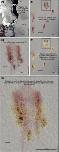
Very high-resolution satellite (VHR) imagery is a promising tool for estimating the abundance of wildlife populations, especially in remote regions where traditional surveys are limited by logistical challenges. Emperor penguins Aptenodytes forsteri were the first species to have a circumpolar population estimate derived via VHR imagery. Here we address an untested assumption from Fretwell et al. (2012) that a single image of an emperor penguin colony is a reasonable representation of the colony for the year the image was taken. We evaluated satellite-related and environmental variables that might influence the calculated area of penguin pixels to reduce uncertainties in satellite-based estimates of emperor penguin populations in the future. We focused our analysis on multiple VHR images from three representative colonies: Atka Bay, Stancomb-Wills (Weddell Sea sector) and Coulman Island (Ross Sea sector) between September and December during 2011. We replicated methods in Fretwell et al. (2012), which included using supervised classification tools in ArcGIS 10.7 software to calculate area occupied by penguins (hereafter referred to as ‘population indices’) in each image. We found that population indices varied from 2 to nearly 6-fold, suggesting that penguin pixel areas calculated from a single image may not provide a complete understanding of colony size for that year. Thus, we further highlight the important roles of: (i) sun azimuth and elevation through image resolution and (ii) penguin patchiness (aggregated vs. distributed) on the calculated areas. We found an effect of wind and temperature on penguin patchiness. Despite intra-seasonal variability in population indices, simulations indicate that reliable, robust population trends are possible by including satellite-related and environmental covariates and aggregating indices across time and space. Our work provides additional parameters that should be included in future models of population size for emperor penguins.
中文翻译:

量化卫星衍生人口指数变化的原因和后果:以帝企鹅为例
超高分辨率卫星 (VHR) 图像是一种很有前途的工具,可用于估计野生动物种群的丰度,尤其是在传统调查受到后勤挑战限制的偏远地区。帝企鹅Aptenodytes forsteri是第一个通过 VHR 图像获得极地种群估计的物种。在这里,我们解决了 Fretwell 等人的未经检验的假设。(2012) 帝企鹅群的单一图像是该图像拍摄年份的群的合理表示。我们评估了可能影响企鹅像素计算面积的卫星相关和环境变量,以减少未来基于卫星的帝企鹅种群估计的不确定性。我们将分析重点放在 2011 年 9 月至 12 月期间来自三个代表性殖民地的多个 VHR 图像:阿特卡湾、斯坦科姆-威尔斯(威德尔海区)和库尔曼岛(罗斯海区)。我们复制了 Fretwell 等人的方法。(2012),其中包括在 ArcGIS 10 中使用监督分类工具。7个软件计算每张图像中企鹅所占的面积(以下简称“人口指数”)。我们发现人口指数从 2 倍到近 6 倍不等,这表明从单个图像计算的企鹅像素区域可能无法提供对当年殖民地大小的完整了解。因此,我们进一步强调了以下重要作用:(i)通过图像分辨率的太阳方位角和仰角以及(ii)计算区域上的企鹅斑块(聚合与分布)。我们发现了风和温度对企鹅斑块的影响。尽管人口指数存在季节性变化,但模拟表明,通过包括卫星相关和环境协变量以及跨时间和空间的聚合指数,可靠、稳健的人口趋势是可能的。
更新日期:2021-08-11
中文翻译:
量化卫星衍生人口指数变化的原因和后果:以帝企鹅为例
超高分辨率卫星 (VHR) 图像是一种很有前途的工具,可用于估计野生动物种群的丰度,尤其是在传统调查受到后勤挑战限制的偏远地区。帝企鹅Aptenodytes forsteri是第一个通过 VHR 图像获得极地种群估计的物种。在这里,我们解决了 Fretwell 等人的未经检验的假设。(2012) 帝企鹅群的单一图像是该图像拍摄年份的群的合理表示。我们评估了可能影响企鹅像素计算面积的卫星相关和环境变量,以减少未来基于卫星的帝企鹅种群估计的不确定性。我们将分析重点放在 2011 年 9 月至 12 月期间来自三个代表性殖民地的多个 VHR 图像:阿特卡湾、斯坦科姆-威尔斯(威德尔海区)和库尔曼岛(罗斯海区)。我们复制了 Fretwell 等人的方法。(2012),其中包括在 ArcGIS 10 中使用监督分类工具。7个软件计算每张图像中企鹅所占的面积(以下简称“人口指数”)。我们发现人口指数从 2 倍到近 6 倍不等,这表明从单个图像计算的企鹅像素区域可能无法提供对当年殖民地大小的完整了解。因此,我们进一步强调了以下重要作用:(i)通过图像分辨率的太阳方位角和仰角以及(ii)计算区域上的企鹅斑块(聚合与分布)。我们发现了风和温度对企鹅斑块的影响。尽管人口指数存在季节性变化,但模拟表明,通过包括卫星相关和环境协变量以及跨时间和空间的聚合指数,可靠、稳健的人口趋势是可能的。


 京公网安备 11010802027423号