Earth-Science Reviews ( IF 10.8 ) Pub Date : 2021-08-04 , DOI: 10.1016/j.earscirev.2021.103757 Wojciech Zgłobicki 1 , Jean Poesen 1, 2 , Sofie De Geeter 2, 3 , John Boardman 4, 5 , Leszek Gawrysiak 1 , Valentin Golosov 6, 7 , Ion Ionita 8 , Lilian Niacsu 8 , Jan Rodzik 1 , Miloš Stankoviansky 9 , Christian Stolz 10
|
Sunken lanes are roads or tracks, 2 m or more wide, that are incised at least 0.5 m, but often by several meters, below the general level of the surrounding land surface. They are formed by the passage of people, animals, vehicles and erosion by water and gravity. Although these anthropogenic landforms are quite common worldwide they received limited interest by the international scientific community. This comprehensive review analyzed all available information on their characteristics, development and functions in landscapes. Most research on sunken lanes has been conducted in Europe, whereas sunken lanes have been occasionally reported in other continents as well. Major topics addressed are spatial distribution, origin and development, morphology, erosion rates, hydrology, ecology, management, geotourism and research needs.
Mean dimensions of sunken lanes reported for various regions vary widely: i.e. 30–2300 m for their length; 0.6–12.5 m for their depth and 2–36 m for their top width. Typical sunken lane densities in European regions (10 to 100 km2 large) characterized by such landforms range between 0.2 and 0.5 km km−2 but for smaller areas (< 10 km2) densities may reach 1–2 km km−2. In Europe and the Middle East sunken lanes already started to form during prehistoric times. During later periods, with increasing population, settlement density, cropland area and traffic, sunken lanes further deepened and widened and new ones were formed. Some of these evolved towards large permanent gullies whereas others became footpaths or were completely abandoned and can still be observed today as dormant sunken lanes in old forests.
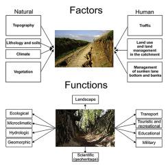
Sunken lane formation results from interactions between natural factors (i.e. lithology and soils, topography, climate, vegetation) and anthropogenic factors (i.e. traffic, land use and management). Rock type, weathering status and soil types control the erodibility of hillslope materials and hence the development and preservation of sunken lanes. Sunken lanes have been reported in several lithologies but most have been studied in loess regions. Sunken lanes, can be initiated at topographic landscape positions with a much lower slope gradient and corresponding contributing area than those needed to initiate classical gullies, due to the combined action of natural (i.e. concentrated flow erosion and mass movements) and anthropogenic processes (i.e. erosion by animal and human trampling, wheel traffic and digging). Once formed, medium to long-term average incision rates of unpaved bare sunken lanes are 1 to 5 cm year−1 often exceeding erosion rates on nearby cropland by at least one order of magnitude.
Sunken lanes perform many functions in landscapes i.e. microclimatological, hydrological, geomorphological, ecological, transport, aesthetic, geotouristic, educational, scientific, strategic, and historical functions. Sunken lanes represent long-standing heritage of past agricultural landscapes and, taking into account their natural and cultural assets, justifies their protection. Unfortunately in several regions, sunken lanes are threatened by urban sprawl, agricultural intensification or land consolidation programs. It remains a challenge for environmental planners to conserve this characteristic geomorphosite for the Anthropocene and to reconcile its competing functions.
中文翻译:
下沉车道 - 景观中的发展和功能
下沉车道是 2 m 或更宽的道路或轨道,在周围地表的总体水平以下至少切开 0.5 m,但通常有几米。它们是由人、动物、车辆的通过以及水和重力的侵蚀形成的。尽管这些人为地貌在世界范围内非常普遍,但国际科学界对它们的兴趣有限。这份全面审查分析了有关其在景观中的特征、发展和功能的所有可用信息。大多数关于下沉车道的研究都是在欧洲进行的,而其他大陆也偶尔会报道下沉车道。讨论的主要主题是空间分布、起源和发展、形态、侵蚀率、水文、生态、管理、地质旅游和研究需求。
不同地区报告的下沉车道的平均尺寸差异很大:即长度为 30-2300 m;深度为 0.6-12.5 m,顶部宽度为 2-36 m。欧洲地区(10 到 100 km 2大)典型的下沉车道密度以此类地貌为特征,范围在 0.2 到 0.5 km -2 之间,但对于较小的区域(< 10 km 2),密度可能达到 1-2 km -2. 在欧洲和中东,在史前时代就已经开始形成下沉车道。后期,随着人口、聚落密度、耕地面积和交通量的增加,下沉巷进一步加深和拓宽,形成了新的下沉巷。其中一些演变成大型永久性沟渠,而另一些则变成了人行道或完全废弃,今天仍然可以观察到作为古老森林中休眠的下沉车道。
下沉车道的形成是自然因素(即岩性和土壤、地形、气候、植被)和人为因素(即交通、土地利用和管理)之间相互作用的结果。岩石类型、风化状态和土壤类型控制着山坡材料的可蚀性,从而控制下沉巷的发展和保存。在几种岩性中已经报道了下沉巷,但大多数是在黄土地区研究的。由于自然(即集中的水流侵蚀和质量运动)和人为过程(即侵蚀)的共同作用,下沉车道可以在坡度梯度和相应贡献面积远低于传统沟渠所需的坡度和相应贡献面积的地形景观位置处开始通过动物和人类的践踏、车轮交通和挖掘)。一旦形成,-1通常超过附近农田的侵蚀率至少一个数量级。
下沉车道在景观中具有多种功能,即小气候、水文、地貌、生态、交通、美学、地质旅游、教育、科学、战略和历史功能。下沉巷是过去农业景观的长期遗产,考虑到它们的自然和文化资产,有理由对其进行保护。不幸的是,在一些地区,下沉车道受到城市扩张、农业集约化或土地整合计划的威胁。对于环境规划者来说,为人类世保护这种特征地貌并协调其竞争功能仍然是一个挑战。


 京公网安备 11010802027423号