当前位置:
X-MOL 学术
›
Clean - Soil Air Water
›
论文详情
Our official English website, www.x-mol.net, welcomes your
feedback! (Note: you will need to create a separate account there.)
Tools for Planning Local Mitigation of Water-Driven Soil Erosion Resulting from Impacts of Future Climate Change
Clean - Soil Air Water ( IF 1.5 ) Pub Date : 2021-08-02 , DOI: 10.1002/clen.202000385 Janine Köhn 1 , Ralph Meißner 2 , Holger Rupp 3 , Frido Reinstorf 1
Clean - Soil Air Water ( IF 1.5 ) Pub Date : 2021-08-02 , DOI: 10.1002/clen.202000385 Janine Köhn 1 , Ralph Meißner 2 , Holger Rupp 3 , Frido Reinstorf 1
Affiliation
|
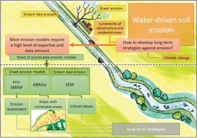
Due to the consequences of climate change impacts municipal planners and local administrations need to develop long-term strategies to protect soil bodies. For this purpose, practicable and free available tools are developed, that allow to estimate the erosivity of rainfall and discharge, considering the effects of land use changes and climate change impacts. This paper presents a stepwise estimation of water erosivity at agricultural areas as well as streams using the developed practicable tools step model of infiltration with calculation of direct flow and soil erosion (ero-SMINF), German universal soil loss equation integrated into a geographic information system (ABAGis), and stream erosion model (SEM). The tools are developed and tested at two catchments in mountainous areas in Central Germany, Vietzbach and Regenbeek. The results for the Vietzbach catchment, which is mostly affected by sheet erosion, indicated that most of the erosive events occur during summer. The most probable change in soil erosion resulting from climate change (RCP8.5) shows an increasing erosion of up to 16% comparing to the current state. In the Regenbeek catchment, where stream bed erosion is dominant, calculations with the SEM show for the same scenario, that erosion can be reduced mainly by widening the stream bed.
中文翻译:

未来气候变化影响导致的水驱动土壤侵蚀的局部缓解规划工具
由于气候变化影响的后果,市政规划者和地方行政部门需要制定长期战略来保护土壤体。为此目的,开发了实用且免费的工具,允许在考虑土地利用变化和气候变化影响的情况下估计降雨和排放的侵蚀性。本文介绍了农业区和河流的水侵蚀力的逐步估计,使用已开发的实用工具步进模型,计算直接流量和土壤侵蚀 (ero-SMINF),将德国通用土壤流失方程集成到地理信息系统中(ABAGis) 和河流侵蚀模型 (SEM)。这些工具是在德国中部山区的两个集水区 Vietzbach 和 Regenbeek 开发和测试的。Vietzbach 流域的结果主要受片材侵蚀的影响,表明大多数侵蚀事件发生在夏季。气候变化导致的土壤侵蚀最可能发生的变化(RCP8.5)显示,与当前状态相比,侵蚀增加了高达 16%。在 Regenbeek 流域,河床侵蚀占主导地位,使用 SEM 的计算表明,对于相同的情景,主要通过拓宽河床来减少侵蚀。
更新日期:2021-08-02
中文翻译:
未来气候变化影响导致的水驱动土壤侵蚀的局部缓解规划工具
由于气候变化影响的后果,市政规划者和地方行政部门需要制定长期战略来保护土壤体。为此目的,开发了实用且免费的工具,允许在考虑土地利用变化和气候变化影响的情况下估计降雨和排放的侵蚀性。本文介绍了农业区和河流的水侵蚀力的逐步估计,使用已开发的实用工具步进模型,计算直接流量和土壤侵蚀 (ero-SMINF),将德国通用土壤流失方程集成到地理信息系统中(ABAGis) 和河流侵蚀模型 (SEM)。这些工具是在德国中部山区的两个集水区 Vietzbach 和 Regenbeek 开发和测试的。Vietzbach 流域的结果主要受片材侵蚀的影响,表明大多数侵蚀事件发生在夏季。气候变化导致的土壤侵蚀最可能发生的变化(RCP8.5)显示,与当前状态相比,侵蚀增加了高达 16%。在 Regenbeek 流域,河床侵蚀占主导地位,使用 SEM 的计算表明,对于相同的情景,主要通过拓宽河床来减少侵蚀。


 京公网安备 11010802027423号