Earth, Planets and Space ( IF 3.0 ) Pub Date : 2021-07-28 , DOI: 10.1186/s40623-021-01474-5 Tomohisa Okazaki 1 , Yukitoshi Fukahata 2 , Takuya Nishimura 2
|
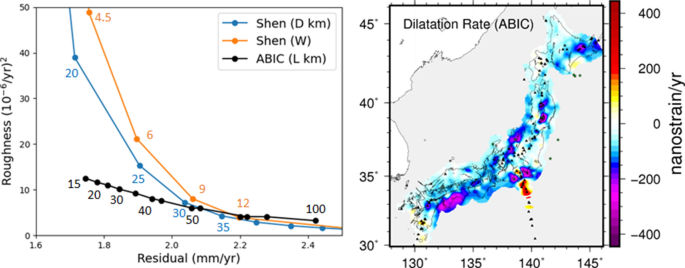
Present day crustal displacement rates can be accurately observed at stations of global navigation satellite system (GNSS), and crustal deformation has been investigated by estimating strain-rate fields from discrete GNSS data. For this purpose, a modified least-square inversion method was proposed by Shen et al. (J Geophys Res 101:27957–27980, 1996). This method offers a simple formulation for simultaneously estimating smooth velocity and strain-rate fields from GNSS data, and it has contributed to clarify crustal deformation fields in many regions all over the world. However, we notice three theoretical points to be examined when we apply the method: mathematical inconsistency between estimated velocity and strain-rate fields, difficulty in objectively determining the optimal value of a hyperparameter that controls smoothness, and inappropriate estimation of uncertainty. In this study, we propose a method of basis function expansion with Akaike’s Bayesian information criterion (ABIC), which overcomes the above difficulties. Application of the two methods to GNSS data in Japan reveals that the inconsistency in the method of Shen et al. is generally insignificant, but could be clear in regions with sparser observation stations such as in islet areas. The method of basis function expansion with ABIC shows a significantly better performance than the method of Shen et al. in terms of the trade-off curve between the residual of fitting and the roughness of velocity field. The estimated strain-rate field with the basis function expansion clearly exhibits a low strain-rate zone in the forearc from the southern Tohoku district to central Japan. We also find that the Ou Backbone Range has several contractive spots around active volcanoes and that these locations well correspond to the subsidence areas detected by InSAR after the 2011 Tohoku-oki earthquake. Thus, the method of basis function expansion with ABIC would serve as an effective tool for estimating strain-rate fields from GNSS data.
中文翻译:
使用基于 ABIC 的基函数扩展从 GNSS 速度数据一致估计应变率场
当今的地壳位移率可以在全球导航卫星系统 (GNSS) 的站点上准确地观测到,并且通过估计离散 GNSS 数据的应变率场来研究地壳变形。为此,Shen 等人提出了一种改进的最小二乘反演方法。(J Geophys Res 101:27957–27980, 1996)。该方法为从 GNSS 数据同时估计平滑速度场和应变率场提供了一个简单的公式,并有助于澄清世界各地许多地区的地壳变形场。然而,当我们应用该方法时,我们注意到三个理论点需要检查:估计速度场和应变率场之间的数学不一致,难以客观地确定控制平滑度的超参数的最佳值,以及对不确定性的不恰当估计。在本研究中,我们提出了一种基于 Akaike 的贝叶斯信息准则 (ABIC) 的基函数扩展方法,克服了上述困难。将这两种方法应用于日本的 GNSS 数据表明,Shen 等人的方法存在不一致之处。通常不显着,但在观测站稀少的地区,如小岛地区,可能很明显。ABIC的基函数扩展方法比Shen等人的方法表现出明显更好的性能。在拟合残差和速度场粗糙度之间的权衡曲线方面。具有基函数扩展的估计应变率场清楚地显示出从东北地区南部到日本中部的前弧中的低应变率区。我们还发现,欧骨干山脉在活火山周围有几个收缩点,这些位置与 InSAR 在 2011 年东北大地震后检测到的沉降区非常吻合。因此,使用 ABIC 的基函数扩展方法将作为从 GNSS 数据估计应变率场的有效工具。


 京公网安备 11010802027423号