当前位置:
X-MOL 学术
›
Earth Surf.Process. Land.
›
论文详情
Our official English website, www.x-mol.net, welcomes your
feedback! (Note: you will need to create a separate account there.)
Climate-change driven increased flood magnitudes and frequency in the British uplands: Geomorphologically informed scientific underpinning for upland flood-risk management
Earth Surface Processes and Landforms ( IF 2.8 ) Pub Date : 2021-07-26 , DOI: 10.1002/esp.5206 David J. Milan 1 , Arved C. Schwendel 2
Earth Surface Processes and Landforms ( IF 2.8 ) Pub Date : 2021-07-26 , DOI: 10.1002/esp.5206 David J. Milan 1 , Arved C. Schwendel 2
Affiliation
|
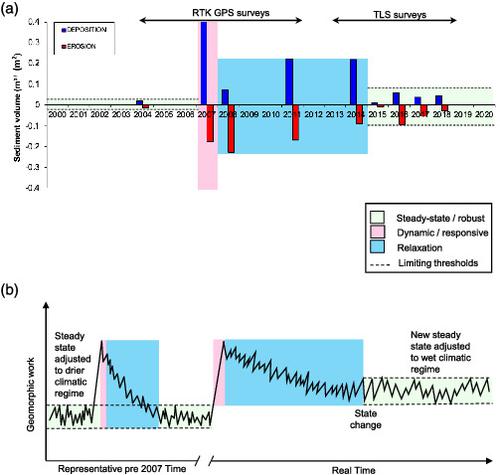
Upland river systems in the UK are predicted to be prone to the effects of increased flood magnitudes and frequency, driven by climate change. It is clear from recent events that some headwater catchments can be very sensitive to large floods, activating the full sediment system, with implications for flood risk management further down the catchment. We provide a 15-year record of detailed morphological change on a 500-m reach of upland gravel-bed river, focusing upon the geomorphic response to an extreme event in 2007, and the recovery in the decade following. Through novel application of two-dimensional (2D) hydrodynamic modelling we evaluate the different energy states of pre- and post-flood morphologies of the river reach, exploring how energy state adjusts with recovery following the event. Following the 2007 flood, morphological adjustments resulted in changes to the shear stress population over the reach, resulting in higher shear stresses. Although the proportion of shear stresses in excess of those experienced using the pre-flood digital elevation model (DEM) varied over the recovery period, they remained substantially in excess of those experienced pre-2007, suggesting that there is still potential for enhanced bedload transport and morphological adjustment within the reach. Although volumetric change calculated from DEM differencing does indicate a reduction in erosion and deposition volumes in the decade following the flood, we argue that the system still has not fully recovered to the pre-flood state. We further argue that Thinhope Burn, and other similarly impacted catchments in upland environments, may not recover under the wet climatic phase currently being experienced. Hence systems like Thinhope Burn will continue to deliver large volumes of sediment further down river catchments, providing new challenges for flood risk management into the future.
中文翻译:

气候变化导致英国高地洪水规模和频率增加:高地洪水风险管理的地貌科学基础
在气候变化的驱动下,预计英国的高地河流系统容易受到洪水规模和频率增加的影响。从最近的事件中可以清楚地看出,一些源头集水区可能对大洪水非常敏感,激活了整个沉积系统,这对流域下游的洪水风险管理产生了影响。我们提供了长达 500 米的高地砾石床河段 15 年的详细形态变化记录,重点关注对 2007 年极端事件的地貌响应以及随后十年的恢复情况。通过二维 (2D) 水动力模型的新应用,我们评估了河段洪水前和洪水后形态的不同能量状态,探索能量状态如何随着事件发生后的恢复而调整。2007年洪水过后,形态调整导致整个河段的剪切应力种群发生变化,从而导致更高的剪切应力。尽管超过洪水前数字高程模型 (DEM) 所经历的剪应力比例在恢复期间有所不同,但它们仍然大大超过 2007 年之前经历的剪应力,这表明仍有可能增强床载运输和形态调整触手可及。尽管从 DEM 差分计算出的体积变化确实表明在洪水后的十年内侵蚀和沉积量减少,但我们认为该系统仍未完全恢复到洪水前的状态。我们进一步争辩说,Thinhope Burn 和其他在高地环境中受到类似影响的集水区,在目前正在经历的潮湿气候阶段下可能无法恢复。因此,像 Thinhope Burn 这样的系统将继续向下游河流集水区输送大量沉积物,为未来的洪水风险管理带来新的挑战。
更新日期:2021-07-26
中文翻译:
气候变化导致英国高地洪水规模和频率增加:高地洪水风险管理的地貌科学基础
在气候变化的驱动下,预计英国的高地河流系统容易受到洪水规模和频率增加的影响。从最近的事件中可以清楚地看出,一些源头集水区可能对大洪水非常敏感,激活了整个沉积系统,这对流域下游的洪水风险管理产生了影响。我们提供了长达 500 米的高地砾石床河段 15 年的详细形态变化记录,重点关注对 2007 年极端事件的地貌响应以及随后十年的恢复情况。通过二维 (2D) 水动力模型的新应用,我们评估了河段洪水前和洪水后形态的不同能量状态,探索能量状态如何随着事件发生后的恢复而调整。2007年洪水过后,形态调整导致整个河段的剪切应力种群发生变化,从而导致更高的剪切应力。尽管超过洪水前数字高程模型 (DEM) 所经历的剪应力比例在恢复期间有所不同,但它们仍然大大超过 2007 年之前经历的剪应力,这表明仍有可能增强床载运输和形态调整触手可及。尽管从 DEM 差分计算出的体积变化确实表明在洪水后的十年内侵蚀和沉积量减少,但我们认为该系统仍未完全恢复到洪水前的状态。我们进一步争辩说,Thinhope Burn 和其他在高地环境中受到类似影响的集水区,在目前正在经历的潮湿气候阶段下可能无法恢复。因此,像 Thinhope Burn 这样的系统将继续向下游河流集水区输送大量沉积物,为未来的洪水风险管理带来新的挑战。


 京公网安备 11010802027423号