当前位置:
X-MOL 学术
›
Earth Surf.Process. Land.
›
论文详情
Our official English website, www.x-mol.net, welcomes your
feedback! (Note: you will need to create a separate account there.)
Hydro-morphological mapping of river reaches using videos captured with UAS
Earth Surface Processes and Landforms ( IF 2.8 ) Pub Date : 2021-07-22 , DOI: 10.1002/esp.5205 A. Eltner 1 , L. Bertalan 2 , J. Grundmann 3 , M. T. Perks 4 , E. Lotsari 5, 6
Earth Surface Processes and Landforms ( IF 2.8 ) Pub Date : 2021-07-22 , DOI: 10.1002/esp.5205 A. Eltner 1 , L. Bertalan 2 , J. Grundmann 3 , M. T. Perks 4 , E. Lotsari 5, 6
Affiliation
|
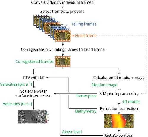
Unoccupied aerial systems (UASs) are frequently used in the field of fluvial geomorphology due to their capabilities for observing the continuum rather than single sample points. We introduce a (semi-)automatic workflow to measure river bathymetry and surface flow velocities of entire river reaches at high resolution, based on UAS videos and imagery. Video frame filtering improved the visibility of the riverbed using frame co-registration and averaging with a median filter. Subsequently, these video frames were incorporated with still images acquired by UASs into a structure from motion (SfM) photogrammetry approach to reconstruct the camera poses (i.e. positions and orientations) and the 3D point cloud of the river reach. The heights of submerged points were further processed using small-angle and multi-view refraction correction approaches to account for the refraction impact. The flow velocity pattern of the river surface was measured using the estimated camera pose from SfM, the reconstructed bathymetric point cloud and the co-registered video frames in combination with image velocimetry analysis. Finally, discharge was estimated at selected cross-sections, considering the average surface velocity and the bathymetry. Three case studies were considered to assess the performance of the workflow under different environmental conditions. The studied river reaches spanned a length between 0.15 and 1 km. The bathymetry was reconstructed with average deviations to RTK-GNSS point measurements as low as 1 cm with a standard deviation of 6 cm. If frames were processed with the median filter, the number of underwater points increased by up to 21%. The image-based surface velocities revealed an average deviation to reference measurements between 0.05 and 0.08 m s−1. The image-based discharge was estimated with deviations to ADCP references of up to 5%, however this was sensitive to errors in water-level retrieval. The output of our workflow can provide a valuable input to hydro-morphological models.
中文翻译:

使用 UAS 捕获的视频对河段进行水文形态测绘
无人空中系统 (UAS) 经常用于河流地貌学领域,因为它们能够观察连续体而不是单个采样点。我们引入了一种(半)自动工作流程,以基于 UAS 视频和图像以高分辨率测量整个河段的河流水深测量和地表流速。视频帧过滤使用帧联合配准和中值滤波器平均提高了河床的可见性。随后,这些视频帧与 UAS 获取的静止图像结合到运动(SfM)摄影测量方法的结构中,以重建相机姿势(即位置和方向)和河段的 3D 点云。使用小角度和多视图折射校正方法进一步处理淹没点的高度,以解决折射影响。河流表面的流速模式是使用来自 SfM 的估计相机姿态、重建的测深点云和共同注册的视频帧结合图像测速分析来测量的。最后,考虑到平均表面速度和测深,在选定的横截面估计流量。考虑了三个案例研究来评估不同环境条件下工作流程的性能。所研究的河段跨度在 0.15 至 1 公里之间。测深重建与 RTK-GNSS 点测量的平均偏差低至 1 cm,标准偏差为 6 cm。如果用中值滤波器处理帧,水下点的数量最多增加 21%。基于图像的表面速度显示与参考测量值的平均偏差在 0.05 和 0.08 m s 之间-1。基于图像的流量估计与 ADCP 参考的偏差高达 5%,但这对水位检索中的错误很敏感。我们工作流程的输出可以为水文形态模型提供有价值的输入。
更新日期:2021-07-22
中文翻译:
使用 UAS 捕获的视频对河段进行水文形态测绘
无人空中系统 (UAS) 经常用于河流地貌学领域,因为它们能够观察连续体而不是单个采样点。我们引入了一种(半)自动工作流程,以基于 UAS 视频和图像以高分辨率测量整个河段的河流水深测量和地表流速。视频帧过滤使用帧联合配准和中值滤波器平均提高了河床的可见性。随后,这些视频帧与 UAS 获取的静止图像结合到运动(SfM)摄影测量方法的结构中,以重建相机姿势(即位置和方向)和河段的 3D 点云。使用小角度和多视图折射校正方法进一步处理淹没点的高度,以解决折射影响。河流表面的流速模式是使用来自 SfM 的估计相机姿态、重建的测深点云和共同注册的视频帧结合图像测速分析来测量的。最后,考虑到平均表面速度和测深,在选定的横截面估计流量。考虑了三个案例研究来评估不同环境条件下工作流程的性能。所研究的河段跨度在 0.15 至 1 公里之间。测深重建与 RTK-GNSS 点测量的平均偏差低至 1 cm,标准偏差为 6 cm。如果用中值滤波器处理帧,水下点的数量最多增加 21%。基于图像的表面速度显示与参考测量值的平均偏差在 0.05 和 0.08 m s 之间-1。基于图像的流量估计与 ADCP 参考的偏差高达 5%,但这对水位检索中的错误很敏感。我们工作流程的输出可以为水文形态模型提供有价值的输入。


 京公网安备 11010802027423号