当前位置:
X-MOL 学术
›
Q. J. R. Meteorol. Soc.
›
论文详情
Our official English website, www.x-mol.net, welcomes your feedback! (Note: you will need to create a separate account there.)
Classifying precipitation from GEO satellite observations: Prognostic model
Quarterly Journal of the Royal Meteorological Society ( IF 8.9 ) Pub Date : 2021-07-19 , DOI: 10.1002/qj.4134 Shruti A. Upadhyaya 1 , Pierre‐Emmanuel Kirstetter 2, 3, 4, 5 , Robert J. Kuligowski 6 , Jonathan J. Gourley 5 , Heather Grams 5
Quarterly Journal of the Royal Meteorological Society ( IF 8.9 ) Pub Date : 2021-07-19 , DOI: 10.1002/qj.4134 Shruti A. Upadhyaya 1 , Pierre‐Emmanuel Kirstetter 2, 3, 4, 5 , Robert J. Kuligowski 6 , Jonathan J. Gourley 5 , Heather Grams 5
Affiliation
|
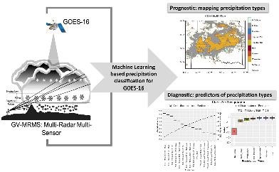
Precipitation is one of the most important components of the global water and energy cycles, which together regulate the climate system. Future changes in precipitation patterns related to climate change are likely to have the greatest impacts on society. The new generation of geostationary Earth orbit (GEO) satellites provide high-resolution observations and opportunities to improve our understanding of precipitation processes. This study contributes to improved precipitation characterization and retrievals from space by identifying precipitation types (e.g., convective and stratiform) with multispectral observations from the Advanced Baseline Imager (ABI) sensor onboard the GOES-16 satellite. A machine-learning-based classification model is developed by deriving a comprehensive set of features using five ABI channels and numerical weather prediction observations, and trained with the Ground Validation Multi-Radar/Multi-Sensor (GV-MRMS) system as a benchmark. The developed prognostic model shows skillful performance in identifying the occurrence/nonoccurrence of precipitation (accuracy of 97%; Kappa coefficient of 0.9) and precipitation processes, with overall classification accuracy of 76% and Kappa coefficient of 0.56. Challenges exist in separating convective and tropical from other precipitation types. It is suggested to utilize probabilities instead of deterministically separating precipitation types, especially in regions with uncertain classifications.
中文翻译:

根据 GEO 卫星观测对降水进行分类:预测模型
降水是全球水和能源循环的最重要组成部分之一,共同调节气候系统。未来与气候变化相关的降水模式变化可能对社会产生最大的影响。新一代地球静止轨道 (GEO) 卫星提供高分辨率观测和机会,以提高我们对降水过程的了解。这项研究通过使用 GOES-16 卫星上的高级基线成像仪 (ABI) 传感器的多光谱观测来识别降水类型(例如,对流和层状),从而有助于改进降水表征和空间反演。基于机器学习的分类模型是通过使用五个 ABI 通道和数值天气预报观测得出一组综合特征来开发的,并以地面验证多雷达/多传感器 (GV-MRMS) 系统为基准进行训练。开发的预测模型在识别降水的发生/不发生(准确率为 97%;Kappa 系数为 0.9)和降水过程方面表现出色,总体分类准确率为 76%,Kappa 系数为 0.56。在将对流和热带降水与其他降水类型分开方面存在挑战。建议利用概率而不是确定性地分离降水类型,尤其是在分类不确定的地区。并以地面验证多雷达/多传感器 (GV-MRMS) 系统为基准进行培训。开发的预测模型在识别降水的发生/不发生(准确率为 97%;Kappa 系数为 0.9)和降水过程方面表现出色,总体分类准确率为 76%,Kappa 系数为 0.56。在将对流和热带降水与其他降水类型分开方面存在挑战。建议利用概率而不是确定性地分离降水类型,尤其是在分类不确定的地区。并以地面验证多雷达/多传感器 (GV-MRMS) 系统为基准进行培训。开发的预测模型在识别降水的发生/不发生(准确率为 97%;Kappa 系数为 0.9)和降水过程方面表现出色,总体分类准确率为 76%,Kappa 系数为 0.56。在将对流和热带降水与其他降水类型分开方面存在挑战。建议利用概率而不是确定性地分离降水类型,尤其是在分类不确定的地区。总体分类准确率为 76%,Kappa 系数为 0.56。在将对流和热带降水与其他降水类型分开方面存在挑战。建议利用概率而不是确定性地分离降水类型,尤其是在分类不确定的地区。总体分类准确率为 76%,Kappa 系数为 0.56。在将对流和热带降水与其他降水类型分开方面存在挑战。建议利用概率而不是确定性地分离降水类型,尤其是在分类不确定的地区。
更新日期:2021-09-06
中文翻译:
根据 GEO 卫星观测对降水进行分类:预测模型
降水是全球水和能源循环的最重要组成部分之一,共同调节气候系统。未来与气候变化相关的降水模式变化可能对社会产生最大的影响。新一代地球静止轨道 (GEO) 卫星提供高分辨率观测和机会,以提高我们对降水过程的了解。这项研究通过使用 GOES-16 卫星上的高级基线成像仪 (ABI) 传感器的多光谱观测来识别降水类型(例如,对流和层状),从而有助于改进降水表征和空间反演。基于机器学习的分类模型是通过使用五个 ABI 通道和数值天气预报观测得出一组综合特征来开发的,并以地面验证多雷达/多传感器 (GV-MRMS) 系统为基准进行训练。开发的预测模型在识别降水的发生/不发生(准确率为 97%;Kappa 系数为 0.9)和降水过程方面表现出色,总体分类准确率为 76%,Kappa 系数为 0.56。在将对流和热带降水与其他降水类型分开方面存在挑战。建议利用概率而不是确定性地分离降水类型,尤其是在分类不确定的地区。并以地面验证多雷达/多传感器 (GV-MRMS) 系统为基准进行培训。开发的预测模型在识别降水的发生/不发生(准确率为 97%;Kappa 系数为 0.9)和降水过程方面表现出色,总体分类准确率为 76%,Kappa 系数为 0.56。在将对流和热带降水与其他降水类型分开方面存在挑战。建议利用概率而不是确定性地分离降水类型,尤其是在分类不确定的地区。并以地面验证多雷达/多传感器 (GV-MRMS) 系统为基准进行培训。开发的预测模型在识别降水的发生/不发生(准确率为 97%;Kappa 系数为 0.9)和降水过程方面表现出色,总体分类准确率为 76%,Kappa 系数为 0.56。在将对流和热带降水与其他降水类型分开方面存在挑战。建议利用概率而不是确定性地分离降水类型,尤其是在分类不确定的地区。总体分类准确率为 76%,Kappa 系数为 0.56。在将对流和热带降水与其他降水类型分开方面存在挑战。建议利用概率而不是确定性地分离降水类型,尤其是在分类不确定的地区。总体分类准确率为 76%,Kappa 系数为 0.56。在将对流和热带降水与其他降水类型分开方面存在挑战。建议利用概率而不是确定性地分离降水类型,尤其是在分类不确定的地区。


 京公网安备 11010802027423号