当前位置:
X-MOL 学术
›
Hydrol. Process.
›
论文详情
Our official English website, www.x-mol.net, welcomes your
feedback! (Note: you will need to create a separate account there.)
Are spatial patterns of soil moisture at plot scales generalisable across catchments, climates, and other characteristics? A synthesis of synoptic soil moisture across the Mid-Atlantic
Hydrological Processes ( IF 2.8 ) Pub Date : 2021-07-17 , DOI: 10.1002/hyp.14313 Charles I. Scaife 1 , Jonathan M. Duncan 2 , Laurence Lin 1 , Christina Tague 3 , Colin Bell 4 , Lawrence Band 1, 5
Hydrological Processes ( IF 2.8 ) Pub Date : 2021-07-17 , DOI: 10.1002/hyp.14313 Charles I. Scaife 1 , Jonathan M. Duncan 2 , Laurence Lin 1 , Christina Tague 3 , Colin Bell 4 , Lawrence Band 1, 5
Affiliation
|
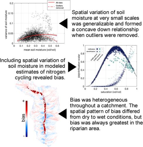
The spatial variation of soil moisture over very small areas (<100 m2) can have nonlinear impacts on cycling and flux rates resulting in bias if it is not considered, but measuring this variation is difficult over extensive temporal and spatial scales. Most studies examining spatial variation of soil moisture were conducted at hillslope (0.01 km2) to multi-catchment spatial scales (1000 km2). They found the greatest variation at mid wetness levels and the smallest variation at wet and dry wetness levels forming a concave down relationship. There is growing evidence that concave down relationships formed between spatial variation of soil moisture and average soil moisture are consistent across spatial scales spanning several orders of magnitude, but more research is needed at very small, plot scales (<100 m2). The goal of this study was to characterise spatial variation in shallow soil moisture at the plot scale by relating the mean of measurements collected in a plot to the standard deviation (SD). We combined data from a previous study with thousands of new soil moisture measurements from 212 plots in eight catchments distributed across the US Mid-Atlantic Region to (1) test for a generalisable mean–SD relationship at plot scales, (2) characterise how landcover, land use, season, and hillslope position contribute to differences in mean–SD relationships, and (3) use these generalised mean–SD relationships to quantify their impacts on catchment scale nitrification and denitrification potential. Our study found that 98% of all measurements formed a generalised mean–SD relationship like those observed at hillslope and catchment spatial scales. The remaining 2% of data comprised a mean–SD relationship with greater spatial variation that originated from two riparian plots reported in a previous study. Incorporating the generalised mean–SD relationship into estimates of nitrification and denitrification potential revealed strong bias that was even greater when incorporating mean–SD observations from the two riparian plots with significantly greater spatial variation.
中文翻译:

地块尺度上土壤水分的空间模式是否可以在集水区、气候和其他特征中推广?大西洋中部天气土壤水分的综合
如果不考虑,非常小的区域(<100 m 2)土壤水分的空间变化会对循环和通量率产生非线性影响,从而导致偏差,但在广泛的时间和空间尺度上测量这种变化是困难的。大多数检验土壤水分空间变化的研究是在山坡(0.01 km 2)到多流域空间尺度(1000 km 2)。他们发现中等湿度水平的变化最大,而湿和干湿度水平的变化最小,形成了下凹的关系。越来越多的证据表明,土壤水分的空间变化与平均土壤水分之间形成的下凹关系在跨越几个数量级的空间尺度上是一致的,但需要在非常小的样地尺度(<100 m 2)。本研究的目标是通过将地块中收集的测量值的平均值与标准偏差 (SD) 相关联来表征地块尺度上浅层土壤水分的空间变化。我们将先前研究的数据与分布在美国大西洋中部地区的 8 个集水区的 212 个地块的数千个新土壤湿度测量值相结合,以 (1) 测试地块尺度上可推广的均值-SD 关系,(2) 表征土地覆盖如何、土地利用、季节和山坡位置导致均值-SD 关系的差异,并且(3)使用这些广义均值-SD 关系来量化它们对集水区规模硝化和反硝化潜力的影响。我们的研究发现,98% 的测量结果形成了广义的均值-SD 关系,就像在山坡和集水区空间尺度上观察到的那样。其余 2% 的数据包含具有更大空间变化的均值-SD 关系,该关系源自先前研究中报告的两个河岸地块。将广义均值-标准差关系纳入硝化和反硝化潜力的估计中,揭示了强烈的偏差,当结合来自两个空间变化显着更大的河岸地块的均值-标准差观测值时,这种偏差甚至更大。
更新日期:2021-09-14
中文翻译:
地块尺度上土壤水分的空间模式是否可以在集水区、气候和其他特征中推广?大西洋中部天气土壤水分的综合
如果不考虑,非常小的区域(<100 m 2)土壤水分的空间变化会对循环和通量率产生非线性影响,从而导致偏差,但在广泛的时间和空间尺度上测量这种变化是困难的。大多数检验土壤水分空间变化的研究是在山坡(0.01 km 2)到多流域空间尺度(1000 km 2)。他们发现中等湿度水平的变化最大,而湿和干湿度水平的变化最小,形成了下凹的关系。越来越多的证据表明,土壤水分的空间变化与平均土壤水分之间形成的下凹关系在跨越几个数量级的空间尺度上是一致的,但需要在非常小的样地尺度(<100 m 2)。本研究的目标是通过将地块中收集的测量值的平均值与标准偏差 (SD) 相关联来表征地块尺度上浅层土壤水分的空间变化。我们将先前研究的数据与分布在美国大西洋中部地区的 8 个集水区的 212 个地块的数千个新土壤湿度测量值相结合,以 (1) 测试地块尺度上可推广的均值-SD 关系,(2) 表征土地覆盖如何、土地利用、季节和山坡位置导致均值-SD 关系的差异,并且(3)使用这些广义均值-SD 关系来量化它们对集水区规模硝化和反硝化潜力的影响。我们的研究发现,98% 的测量结果形成了广义的均值-SD 关系,就像在山坡和集水区空间尺度上观察到的那样。其余 2% 的数据包含具有更大空间变化的均值-SD 关系,该关系源自先前研究中报告的两个河岸地块。将广义均值-标准差关系纳入硝化和反硝化潜力的估计中,揭示了强烈的偏差,当结合来自两个空间变化显着更大的河岸地块的均值-标准差观测值时,这种偏差甚至更大。


 京公网安备 11010802027423号