当前位置:
X-MOL 学术
›
Q. J. R. Meteorol. Soc.
›
论文详情
Our official English website, www.x-mol.net, welcomes your
feedback! (Note: you will need to create a separate account there.)
Dynamics of forecast-error growth along cut-off Sanchez and its consequence for the prediction of a high-impact weather event over southern France
Quarterly Journal of the Royal Meteorological Society ( IF 3.0 ) Pub Date : 2021-07-16 , DOI: 10.1002/qj.4127 Hanin Binder 1, 2 , Gwendal Rivière 1 , Philippe Arbogast 3 , Karine Maynard 3 , Pierre Bosser 4 , Bruno Joly 3 , Carole Labadie 3
Quarterly Journal of the Royal Meteorological Society ( IF 3.0 ) Pub Date : 2021-07-16 , DOI: 10.1002/qj.4127 Hanin Binder 1, 2 , Gwendal Rivière 1 , Philippe Arbogast 3 , Karine Maynard 3 , Pierre Bosser 4 , Bruno Joly 3 , Carole Labadie 3
Affiliation
|
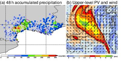
The representation of a high-impact weather (HIW) event over southern France is evaluated in Météo-France forecasts, and the sensitivity of the HIW forecast to the upstream upper-level flow and the Mediterranean and North Atlantic humidity structure prior to the event is quantified. The event occurred in October 2016 during the international field experiment NAWDEX. The approach of an upper-level potential vorticity (PV) cut-off, referred to as cut-off , triggered extreme precipitation over southern France. Many 2- to 7-day ensemble forecasts predicted the maximum of the extreme precipitation and the location of the upper-level PV cut-off too far to the east. This eastward shift primarily resulted from an underestimation of the cut-off intensity two days before the HIW and the subsequent downstream propagation and amplification of these errors in the vicinity of . Improving the representation of the cut-off two days before the event significantly improved the forecast quality. Another error source were inaccuracies in the moisture structure in the eastern North Atlantic. Specifically, an underestimation of the moisture in the warm conveyor belt inflow led to errors in the low- and upper-level circulation that eventually contributed to the eastward shift of the HIW two days later. Corrections in the eastern North Atlantic humidity structure further improved the forecast quality. On the other hand, corrections in the Mediterranean humidity structure had only a small impact on the accuracy of the forecast. The findings illustrate the importance of downstream error propagation and moist diabatic processes for the prediction of extreme weather over Europe, and demonstrate how targeted changes in the PV and humidity field a few days in advance can improve the quality of the forecasts.
中文翻译:

沿桑切斯截止点的预报误差增长动态及其对法国南部高影响天气事件预测的影响
Météo-France 预报评估了法国南部高影响天气 (HIW) 事件的代表性,并且 HIW 预报对事件发生前的上游高层流量以及地中海和北大西洋湿度结构的敏感性为量化。该事件发生在 2016 年 10 月国际田间试验 NAWDEX 期间。接近上层位涡 (PV) 截止点,称为截止点,引发了法国南部的极端降水。许多 2 至 7 天的集合预报预测了极端降水的最大值和上层 PV 截止点的位置向东太远。这种东移主要是由于 HIW 前两天对截止强度的低估以及随后这些误差在 附近的下游传播和放大. 改进事件前两天截止点的表示显着提高了预测质量。另一个错误来源是北大西洋东部的水分结构不准确。具体来说,对温暖的传送带流入中水分的低估导致了低层和高层环流的错误,最终导致了两天后 HIW 向东移动。北大西洋东部湿度结构的修正进一步提高了预报质量。另一方面,地中海湿度结构的修正对预报的准确性影响很小。研究结果说明了下游误差传播和潮湿的非绝热过程对于预测欧洲极端天气的重要性,
更新日期:2021-09-06
中文翻译:
沿桑切斯截止点的预报误差增长动态及其对法国南部高影响天气事件预测的影响
Météo-France 预报评估了法国南部高影响天气 (HIW) 事件的代表性,并且 HIW 预报对事件发生前的上游高层流量以及地中海和北大西洋湿度结构的敏感性为量化。该事件发生在 2016 年 10 月国际田间试验 NAWDEX 期间。接近上层位涡 (PV) 截止点,称为截止点,引发了法国南部的极端降水。许多 2 至 7 天的集合预报预测了极端降水的最大值和上层 PV 截止点的位置向东太远。这种东移主要是由于 HIW 前两天对截止强度的低估以及随后这些误差在 附近的下游传播和放大. 改进事件前两天截止点的表示显着提高了预测质量。另一个错误来源是北大西洋东部的水分结构不准确。具体来说,对温暖的传送带流入中水分的低估导致了低层和高层环流的错误,最终导致了两天后 HIW 向东移动。北大西洋东部湿度结构的修正进一步提高了预报质量。另一方面,地中海湿度结构的修正对预报的准确性影响很小。研究结果说明了下游误差传播和潮湿的非绝热过程对于预测欧洲极端天气的重要性,


 京公网安备 11010802027423号