当前位置:
X-MOL 学术
›
Geolog. J.
›
论文详情
Our official English website, www.x-mol.net, welcomes your
feedback! (Note: you will need to create a separate account there.)
Integration of Landsat 8, gravity, and field data for exploration of gold mineralization in Gamba District, Northern Cameroon
Geological Journal ( IF 1.4 ) Pub Date : 2021-07-10 , DOI: 10.1002/gj.4197 Yanick Blaise Ketchaya 1, 2 , Guochen Dong 1 , Quentin Marc Anaba Fotze 3 , Thais Andressa Carrino 4 , Eugene Pascal Binam Mandeng 3 , Yanick Brice Lemdjou 1, 2 , Konan Roger Assie 5 , Yaya Fodoue 3 , Jacques Wassouo Wadjou 3
Geological Journal ( IF 1.4 ) Pub Date : 2021-07-10 , DOI: 10.1002/gj.4197 Yanick Blaise Ketchaya 1, 2 , Guochen Dong 1 , Quentin Marc Anaba Fotze 3 , Thais Andressa Carrino 4 , Eugene Pascal Binam Mandeng 3 , Yanick Brice Lemdjou 1, 2 , Konan Roger Assie 5 , Yaya Fodoue 3 , Jacques Wassouo Wadjou 3
Affiliation
|
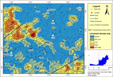
Remote sensing is a robust and useful tool for providing high-resolution image data and enabling reliable geological mapping during the initial stage of mineral exploration. One of its main applications is the extraction of lineaments and to locate alteration areas to target gold exploration. It has been long used in the Pan-African belt of Cameroon to identify a hydrothermal alteration and a great number of lineaments associated with mineralizations. The study area located in the Pan-African belt hosts numerous alluvial gold deposits where the primary mineralization was still largely poorly unknown until now, due to deep weathering. Therefore, remote sensing combined with field data is useful for targeting potential zones of primary gold resources involved in the hydrothermal and lineament systems. In this study, remote sensing data from Landsat 8 imagery were selected to map the distribution of hydrothermal minerals, and gravity data were interpreted for highlighting structural patterns related to the control of high-potential zone for gold mineralization, generating a mineral prospect map. The lineaments network shows directions ranging from ENE-WSW to E-W, with main direction N45° and a secondary striking N275°. Image enhancement/processing techniques included the application of band ratio and principal component analysis that were helpful to demarcate potential alteration zones marked by iron oxide/hydroxides in which haematite and pyrite are used as proximal alterations and hydroxyl-bearing minerals in which sericite (muscovite) is used as a marker of proximal alteration, while chlorite, epidote, biotite, quartz, and calcite are used as distal alteration zone, as described by field and petrographic data. The identified alteration zones display a high consistency with the known locations of gold occurrences (mining sites) and closely concordant with large-scale gold mineralization in the study area. This study presents an integrated approach of Landsat 8 imagery with gravity data and field data for discovering primary mineral resources in a deep weathering area.
中文翻译:

Landsat 8、重力和野外数据的整合,用于喀麦隆北部甘巴区金矿化勘探
遥感是一种强大且有用的工具,可在矿产勘探的初始阶段提供高分辨率图像数据并实现可靠的地质绘图。它的主要应用之一是提取线条和定位蚀变区以进行金矿勘探。长期以来,它一直被用于喀麦隆泛非带以识别热液蚀变和大量与矿化相关的线条。位于泛非带的研究区拥有众多冲积金矿床,由于深度风化,迄今为止主要矿化作用在很大程度上仍然鲜为人知。因此,遥感与现场数据相结合对于瞄准热液和线性系统中涉及的原始金资源的潜在区域很有用。在这项研究中,选取 Landsat 8 影像遥感数据绘制热液矿物分布图,解释重力数据以突出与控制金矿化高潜力带相关的结构模式,生成矿产远景图。线条网络显示了从 ENE-WSW 到 EW 的方向,主要方向为 N45°,次要方向为 N275°。图像增强/处理技术包括应用带比和主成分分析,这有助于划定以氧化铁/氢氧化物为标志的潜在蚀变带,其中赤铁矿和黄铁矿用作近端蚀变,以及含羟基矿物,其中绢云母(白云母)用作近端蚀变的标志,而绿泥石、绿帘石、黑云母、石英、和方解石被用作远侧蚀变带,如野外和岩相数据所述。识别出的蚀变带与已知的金产地(矿点)高度一致,与研究区的大规模金矿化密切相关。本研究提出了一种将 Landsat 8 图像与重力数据和野外数据相结合的综合方法,用于在深风化区发现原生矿产资源。
更新日期:2021-09-02
中文翻译:
Landsat 8、重力和野外数据的整合,用于喀麦隆北部甘巴区金矿化勘探
遥感是一种强大且有用的工具,可在矿产勘探的初始阶段提供高分辨率图像数据并实现可靠的地质绘图。它的主要应用之一是提取线条和定位蚀变区以进行金矿勘探。长期以来,它一直被用于喀麦隆泛非带以识别热液蚀变和大量与矿化相关的线条。位于泛非带的研究区拥有众多冲积金矿床,由于深度风化,迄今为止主要矿化作用在很大程度上仍然鲜为人知。因此,遥感与现场数据相结合对于瞄准热液和线性系统中涉及的原始金资源的潜在区域很有用。在这项研究中,选取 Landsat 8 影像遥感数据绘制热液矿物分布图,解释重力数据以突出与控制金矿化高潜力带相关的结构模式,生成矿产远景图。线条网络显示了从 ENE-WSW 到 EW 的方向,主要方向为 N45°,次要方向为 N275°。图像增强/处理技术包括应用带比和主成分分析,这有助于划定以氧化铁/氢氧化物为标志的潜在蚀变带,其中赤铁矿和黄铁矿用作近端蚀变,以及含羟基矿物,其中绢云母(白云母)用作近端蚀变的标志,而绿泥石、绿帘石、黑云母、石英、和方解石被用作远侧蚀变带,如野外和岩相数据所述。识别出的蚀变带与已知的金产地(矿点)高度一致,与研究区的大规模金矿化密切相关。本研究提出了一种将 Landsat 8 图像与重力数据和野外数据相结合的综合方法,用于在深风化区发现原生矿产资源。


 京公网安备 11010802027423号