当前位置:
X-MOL 学术
›
Earth Surf.Process. Land.
›
论文详情
Our official English website, www.x-mol.net, welcomes your
feedback! (Note: you will need to create a separate account there.)
Quantifying sediment connectivity: Moving toward a holistic assessment through a mixed methods approach
Earth Surface Processes and Landforms ( IF 2.8 ) Pub Date : 2021-07-08 , DOI: 10.1002/esp.5191 Mike Turley 1 , Marwan A. Hassan 1 , Olav Slaymaker 1
Earth Surface Processes and Landforms ( IF 2.8 ) Pub Date : 2021-07-08 , DOI: 10.1002/esp.5191 Mike Turley 1 , Marwan A. Hassan 1 , Olav Slaymaker 1
Affiliation
|
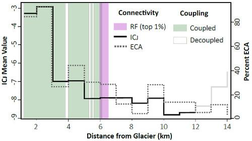
The sediment connectivity concept is particularly suitable for tackling complex, multidisciplinary questions through systems thinking. However, it is unclear how to directly measure connectivity, and so proxy variables are often applied by indices to provide estimates. In this study, we critically evaluate a broad range of connectivity indices encompassing structural and functional connectivity as well as hillslope channel coupling. We then discuss their role in providing a more holistic estimation of connectivity within the Tahoma Creek Watershed, WA. Of the 14 km of channel below the glacier front, the upper 6 km (0–6 km) are coupled to the adjacent hillslopes. Coupled reaches correspond to regions with a high proportion of area contributing sediment and relatively high connectivity values, where all measures decrease in the downstream direction. A significant transition occurs near river kilometer 6. Here the valley bottom abruptly widens, deposition occurs, and the hillslopes become decoupled from the active channel. This transitional reach is also identified as a geomorphic hotspot based on the network structure. The lower 8 km of channel downstream of this reach are largely depositional and percent contributing area and connectivity values remain low, eventually reaching a minimum. Despite their limitations, we found each method to provide unique and useful information regarding connectivity. The effect of scale and event magnitude on connectivity is illustrated. We also found vegetation, topographic characteristics, and network structure to be important in high-gradient glacio-volcanic landscapes. The choice of an index will depend on the research objectives, data availability, and the proxy variables that best describe the variability within the defined area.
中文翻译:

量化沉积物连通性:通过混合方法进行整体评估
沉积物连通性概念特别适合通过系统思考解决复杂的多学科问题。然而,尚不清楚如何直接测量连通性,因此指数经常应用代理变量来提供估计值。在这项研究中,我们批判性地评估了广泛的连通性指标,包括结构和功能连通性以及山坡通道耦合。然后,我们讨论了它们在对华盛顿州塔霍马溪流域内的连通性提供更全面的估计方面的作用。在冰川前缘以下 14 公里的通道中,上部 6 公里(0-6 公里)与相邻的山坡相连。耦合河段对应于贡献沉积物面积比例高且连通性值相对较高的区域,其中所有措施都在下游方向减少。在河流 6 公里附近发生了显着的转变。这里的谷底突然变宽,发生沉积,山坡与活动河道脱钩。这种过渡范围也被确定为基于网络结构的地貌热点。该河段下游下游 8 公里的河道主要是沉积物,贡献面积和连通性值的百分比仍然很低,最终达到最小值。尽管存在局限性,但我们发现每种方法都可以提供有关连接性的独特且有用的信息。说明了规模和事件幅度对连通性的影响。我们还发现植被、地形特征和网络结构在高梯度冰川-火山景观中很重要。
更新日期:2021-09-16
中文翻译:
量化沉积物连通性:通过混合方法进行整体评估
沉积物连通性概念特别适合通过系统思考解决复杂的多学科问题。然而,尚不清楚如何直接测量连通性,因此指数经常应用代理变量来提供估计值。在这项研究中,我们批判性地评估了广泛的连通性指标,包括结构和功能连通性以及山坡通道耦合。然后,我们讨论了它们在对华盛顿州塔霍马溪流域内的连通性提供更全面的估计方面的作用。在冰川前缘以下 14 公里的通道中,上部 6 公里(0-6 公里)与相邻的山坡相连。耦合河段对应于贡献沉积物面积比例高且连通性值相对较高的区域,其中所有措施都在下游方向减少。在河流 6 公里附近发生了显着的转变。这里的谷底突然变宽,发生沉积,山坡与活动河道脱钩。这种过渡范围也被确定为基于网络结构的地貌热点。该河段下游下游 8 公里的河道主要是沉积物,贡献面积和连通性值的百分比仍然很低,最终达到最小值。尽管存在局限性,但我们发现每种方法都可以提供有关连接性的独特且有用的信息。说明了规模和事件幅度对连通性的影响。我们还发现植被、地形特征和网络结构在高梯度冰川-火山景观中很重要。


 京公网安备 11010802027423号