当前位置:
X-MOL 学术
›
Earth Surf.Process. Land.
›
论文详情
Our official English website, www.x-mol.net, welcomes your feedback! (Note: you will need to create a separate account there.)
Using legacy data to reconstruct the past? Rescue, rigour and reuse in peatland geochronology
Earth Surface Processes and Landforms ( IF 3.3 ) Pub Date : 2021-07-07 , DOI: 10.1002/esp.5196 Cindy Quik 1 , Ype Velde 2 , Tom Harkema 1 , Hans Plicht 3 , Jim Quik 4 , Roy Beek 1, 5 , Jakob Wallinga 1
Earth Surface Processes and Landforms ( IF 3.3 ) Pub Date : 2021-07-07 , DOI: 10.1002/esp.5196 Cindy Quik 1 , Ype Velde 2 , Tom Harkema 1 , Hans Plicht 3 , Jim Quik 4 , Roy Beek 1, 5 , Jakob Wallinga 1
Affiliation
|
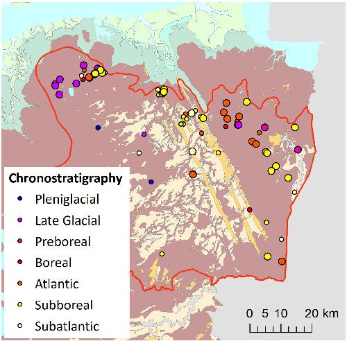
There is a growing interest in the rescue and reuse of data from past studies (so-called legacy data). Data loss is alarming, especially where natural archives are under threat, such as peat deposits. Here we develop a workflow for reuse of legacy radiocarbon dates in peatland studies, including a rigorous quality assessment that can be tailored to specific research questions and study regions. A penalty is assigned to each date based on criteria that consider taphonomic quality (i.e., sample provenance) and dating quality (i.e., sample material and method used). The weights of quality criteria may be adjusted based on the research focus, and resulting confidence levels may be used in further analyses to ensure robustness of conclusions. We apply the proposed approach to a case study of a (former) peat landscape in the Netherlands, aiming to reconstruct the timing of peat initiation spatially. Our search yielded 313 radiocarbon dates from the 1950s to 2019. Based on the quality assessment, the dates—of highly diverse quality—were assigned to four confidence levels. Results indicate that peat initiation for the study area first peaked in the Late Glacial (~14,000 cal years BP), dropped during the Boreal (~9,500 cal years BP) and showed a second peak in the Subboreal (~4,500 cal years BP). We tentatively conclude that the earliest peak was mostly driven by climate (Bølling–Allerød interstadial), whereas the second was probably the result of Holocene sea level rise and related groundwater level rise in combination with climatic conditions (hypsithermal). Our study highlights the potential of legacy data for palaeogeographic reconstructions, as it is cost-efficient and provides access to information no longer available in the field. However, data retrieval may be challenging, and reuse of data requires that basic information on location, elevation, stratigraphy, sample and laboratory analysis are documented irrespective of the original research aims.
中文翻译:

使用遗留数据重建过去?泥炭地年代学中的拯救、严谨和再利用
人们对拯救和重用过去研究的数据(所谓的遗留数据)越来越感兴趣。数据丢失令人震惊,尤其是在泥炭沉积等自然档案受到威胁的情况下。在这里,我们开发了在泥炭地研究中重复使用遗留放射性碳日期的工作流程,包括可以针对特定研究问题和研究区域量身定制的严格质量评估。根据考虑埋藏质量(即样品来源)和测年质量(即使用的样品材料和方法)的标准,对每个日期进行处罚。质量标准的权重可以根据研究重点进行调整,得到的置信水平可以用于进一步的分析,以确保结论的稳健性。我们将提议的方法应用于荷兰(前)泥炭景观的案例研究,旨在从空间上重建泥炭起始的时间。我们的搜索产生了从 1950 年代到 2019 年的 313 个放射性碳日期。根据质量评估,质量高度多样化的日期被分配到四个置信水平。结果表明,研究区的泥炭起始在晚冰期(~14,000 cal年BP)首次达到顶峰,在北方(~9,500 cal年BP)期间下降,并在亚北方(~4,500 cal年BP)出现第二个高峰。我们初步得出结论,最早的峰值主要是由气候驱动的(Bølling-Allerød interstadial),而第二个可能是全新世海平面上升和相关地下水位上升与气候条件(低温)相结合的结果。我们的研究强调了遗留数据对古地理重建的潜力,因为它具有成本效益,并且可以访问该领域不再可用的信息。然而,数据检索可能具有挑战性,并且数据的重用需要记录关于位置、海拔、地层、样本和实验室分析的基本信息,而不管最初的研究目的如何。
更新日期:2021-07-07
中文翻译:
使用遗留数据重建过去?泥炭地年代学中的拯救、严谨和再利用
人们对拯救和重用过去研究的数据(所谓的遗留数据)越来越感兴趣。数据丢失令人震惊,尤其是在泥炭沉积等自然档案受到威胁的情况下。在这里,我们开发了在泥炭地研究中重复使用遗留放射性碳日期的工作流程,包括可以针对特定研究问题和研究区域量身定制的严格质量评估。根据考虑埋藏质量(即样品来源)和测年质量(即使用的样品材料和方法)的标准,对每个日期进行处罚。质量标准的权重可以根据研究重点进行调整,得到的置信水平可以用于进一步的分析,以确保结论的稳健性。我们将提议的方法应用于荷兰(前)泥炭景观的案例研究,旨在从空间上重建泥炭起始的时间。我们的搜索产生了从 1950 年代到 2019 年的 313 个放射性碳日期。根据质量评估,质量高度多样化的日期被分配到四个置信水平。结果表明,研究区的泥炭起始在晚冰期(~14,000 cal年BP)首次达到顶峰,在北方(~9,500 cal年BP)期间下降,并在亚北方(~4,500 cal年BP)出现第二个高峰。我们初步得出结论,最早的峰值主要是由气候驱动的(Bølling-Allerød interstadial),而第二个可能是全新世海平面上升和相关地下水位上升与气候条件(低温)相结合的结果。我们的研究强调了遗留数据对古地理重建的潜力,因为它具有成本效益,并且可以访问该领域不再可用的信息。然而,数据检索可能具有挑战性,并且数据的重用需要记录关于位置、海拔、地层、样本和实验室分析的基本信息,而不管最初的研究目的如何。


 京公网安备 11010802027423号