当前位置:
X-MOL 学术
›
Earth Surf.Process. Land.
›
论文详情
Our official English website, www.x-mol.net, welcomes your
feedback! (Note: you will need to create a separate account there.)
Formation, mechanism and significance of alluvial-dammed lakes in Golmud River catchment, north-eastern Qinghai-Tibetan Plateau
Earth Surface Processes and Landforms ( IF 2.8 ) Pub Date : 2021-07-06 , DOI: 10.1002/esp.5186 Fuyuan An 1, 2, 3 , Tianyuan Chen 4 , Xiangzhong Li 3, 5 , Xiangjun Liu 6 , Yixuan Wang 4 , Zongyan Chen 1 , Chongyi E 1, 2, 3
Earth Surface Processes and Landforms ( IF 2.8 ) Pub Date : 2021-07-06 , DOI: 10.1002/esp.5186 Fuyuan An 1, 2, 3 , Tianyuan Chen 4 , Xiangzhong Li 3, 5 , Xiangjun Liu 6 , Yixuan Wang 4 , Zongyan Chen 1 , Chongyi E 1, 2, 3
Affiliation
|
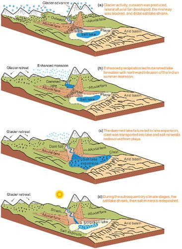
This study investigated a series of dammed lakes and downstream-adjacent alluvial fans in the upstream to middle reaches of the Golmud River in the eastern Kunlun Mountain, on the north-eastern Qinghai-Tibetan Plateau (QTP). An optically stimulated luminescence (OSL) chronology shows the sediments of five dammed lakes developed from c. 45–40, 30–25, 18–14, and 12–8 ka, corresponding to MIS 3b, late MIS 3a, Last Deglaciation, and early Holocene, respectively. The remote sensing data show these dammed lakes have a total area of 109.4 km2, with the lake volume of more than 4.0 km3. Symmetric alluvial fans from north–south tributary valleys produced OSL ages of c. 61–52, 42–31, 26–20, and 16–10 ka, corresponding to glaciation periods: the MIS 3c and MIS 3a, MIS 2, and the Last Deglaciation. This suggests that glacial activity is responsible for the alluvial fan development, where dammed rivers occurred first, but lake formation did not take place synchronously until later periods of strong hydrologic activity, resulting from northward intrusions of the Indian summer monsoon (ISM) or glacier melt. Thus, the blocking pattern is that river valleys were dammed during periods of glacial activity and lakes formed during wet periods. The lake formation and subsequent drainage may have resulted in: (i) impeded headwater incision and strengthening of downstream dissection; (ii) enriched the halite and potash in the distal Qarhan Salt Lake through hydrologic and hydrochemical processes of abundant water input, the salt lake expansion, salt redissolution from playa and final resedimentation during later dry periods. The alluvial-dammed lake pattern in the mountain-basin systems of eastern Kunlun Mountain offers a model for assessing the linkages between monsoon dynamics, geomorphic processes and distal salt lake evolutions in other arid regions.
中文翻译:

青藏高原东北部格尔木河流域冲积堰塞湖的形成、机制及意义
本研究调查了青藏高原东北部昆仑山东部格尔木河上游至中游的一系列堰塞湖和下游相邻的冲积扇。光学受激发光 (OSL) 年表显示了从c开发的五个堰塞湖的沉积物。45–40、30–25、18–14 和 12–8 ka,分别对应于 MIS 3b、晚 MIS 3a、末次冰消期和早全新世。遥感数据显示,这些堰塞湖总面积109.4 km 2,湖水量超过4.0 km 3。来自南北支流河谷的对称冲积扇产生的 OSL 年龄为c. 61–52、42–31、26–20 和 16–10 ka,对应于冰川期:MIS 3c 和 MIS 3a、MIS 2 和末次冰消期。这表明冰川活动是冲积扇发展的原因,首先出现了堰塞河,但湖泊形成直到后期强烈的水文活动时期才同步发生,这是由于印度夏季风(ISM)或冰川融化向北侵入造成的. 因此,阻塞模式是河谷在冰川活动期间被筑坝,而湖泊则在潮湿期间形成。湖泊的形成和随后的排水可能导致:(i) 阻碍了上游切割和下游解剖的加强;(ii) 通过大量输水的水文和水化学过程,富集了察尔汗盐湖远端的岩盐和钾盐,盐湖扩张、盐分从海滩重新溶解以及在后期干旱期的最终再沉积。昆仑山东部山盆系统的冲积堰塞湖格局为评估其他干旱地区季风动力学、地貌过程和远端盐湖演化之间的联系提供了模型。
更新日期:2021-07-06
中文翻译:
青藏高原东北部格尔木河流域冲积堰塞湖的形成、机制及意义
本研究调查了青藏高原东北部昆仑山东部格尔木河上游至中游的一系列堰塞湖和下游相邻的冲积扇。光学受激发光 (OSL) 年表显示了从c开发的五个堰塞湖的沉积物。45–40、30–25、18–14 和 12–8 ka,分别对应于 MIS 3b、晚 MIS 3a、末次冰消期和早全新世。遥感数据显示,这些堰塞湖总面积109.4 km 2,湖水量超过4.0 km 3。来自南北支流河谷的对称冲积扇产生的 OSL 年龄为c. 61–52、42–31、26–20 和 16–10 ka,对应于冰川期:MIS 3c 和 MIS 3a、MIS 2 和末次冰消期。这表明冰川活动是冲积扇发展的原因,首先出现了堰塞河,但湖泊形成直到后期强烈的水文活动时期才同步发生,这是由于印度夏季风(ISM)或冰川融化向北侵入造成的. 因此,阻塞模式是河谷在冰川活动期间被筑坝,而湖泊则在潮湿期间形成。湖泊的形成和随后的排水可能导致:(i) 阻碍了上游切割和下游解剖的加强;(ii) 通过大量输水的水文和水化学过程,富集了察尔汗盐湖远端的岩盐和钾盐,盐湖扩张、盐分从海滩重新溶解以及在后期干旱期的最终再沉积。昆仑山东部山盆系统的冲积堰塞湖格局为评估其他干旱地区季风动力学、地貌过程和远端盐湖演化之间的联系提供了模型。


 京公网安备 11010802027423号