Earth, Planets and Space ( IF 3.0 ) Pub Date : 2021-07-06 , DOI: 10.1186/s40623-021-01466-5 Takao Koyama 1 , Takayuki Kaneko 1 , Takao Ohminato 1 , Atsushi Watanabe 1 , Hiroshi Tsuji 1 , Taro Nishimoto 1 , Alexey Kuvshinov 1, 2 , Wataru Kanda 3 , Mitsuru Utsugi 4 , Yoshiaki Honda 5
|
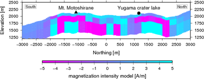
Kusatsu-Shirane volcano is one of the active volcanoes in Japan. Phreatic explosions occurred in Mt. Shirane in 1983 and most recently, in 2018, in Mt. Motoshirane. Information on the subsurface structure is crucial for understanding the activity of volcanoes with well-developed hydrothermal systems where phreatic eruptions occur. Here, we report aeromagnetic surveys conducted at low altitudes using an unmanned helicopter. The survey aimed to obtain magnetic data at a high spatial resolution to map the magnetic anomaly and infer the magnetization intensity distribution in the region immediately after the 2018 Mt. Motoshirane eruption. The helicopter used in the survey was YAMAHA FAZER R G2, an autonomously driven model which can fly along a precisely programmed course. The flight height above the ground and a measurement line spacing were set to ~ 150 m and ~ 100 m, respectively, and the total flight distance was 191 km. The measured geomagnetic total intensity was found to vary by ~ 1000 nT peak-to-peak. The estimated magnetization intensity derived from measured data showed a 100 m thick magnetized surface layer with normal polarity, composed of volcanic deposits of recent activities. Underneath, a reverse-polarity magnetization was found, probably corresponding to the Takai lava flow in the Early Quaternary period (~ 1 Ma) mapped in the region. Our results demonstrate the cost-effectiveness and accuracy of using drone magnetometers for mapping the rugged terrain of volcanoes.
中文翻译:
使用无人直升机在日本中部草津白根火山进行气磁测量
草津白根火山是日本的活火山之一。Mt.发生了潜水爆炸。Shirane 于 1983 年,最近一次是在 2018 年,在 Mt. 元白根。关于地下结构的信息对于了解具有发达的热液系统的火山活动至关重要,其中发生潜水喷发。在这里,我们报告了使用无人驾驶直升机在低空进行的航磁调查。该调查旨在以高空间分辨率获得磁数据,以绘制磁异常并推断 2018 年 Mt. 之后该地区的磁化强度分布。本白根火山喷发。调查中使用的直升机是 YAMAHA FAZER R G2,这是一种自动驾驶模型,可以沿着精确编程的航线飞行。地面以上飞行高度和测量线间距分别设置为~150 m和~100 m,总飞行距离为191 km。发现测得的地磁总强度在峰峰值之间变化约 1000 nT。从测量数据推导出的估计磁化强度显示了一个 100 m 厚的磁化表面层,具有正常极性,由近期活动的火山沉积物组成。在下方,发现了反极性磁化,可能对应于该地区绘制的早第四纪(~1 Ma)的 Takai 熔岩流。我们的结果证明了使用无人机磁力计绘制火山崎岖地形图的成本效益和准确性。发现测得的地磁总强度在峰峰值之间变化约 1000 nT。从测量数据推导出的估计磁化强度显示了一个 100 m 厚的磁化表面层,具有正常极性,由近期活动的火山沉积物组成。在下方,发现了反极性磁化,可能对应于该地区绘制的早第四纪(~1 Ma)的 Takai 熔岩流。我们的结果证明了使用无人机磁力计绘制火山崎岖地形图的成本效益和准确性。发现测得的地磁总强度在峰峰值之间变化约 1000 nT。从测量数据推导出的估计磁化强度显示了一个 100 m 厚的磁化表面层,具有正常极性,由近期活动的火山沉积物组成。在下方,发现了反极性磁化,可能对应于该地区绘制的早第四纪(~1 Ma)的 Takai 熔岩流。我们的结果证明了使用无人机磁力计绘制火山崎岖地形图的成本效益和准确性。可能对应于该地区绘制的早第四纪(~1 Ma)的 Takai 熔岩流。我们的结果证明了使用无人机磁力计绘制火山崎岖地形图的成本效益和准确性。可能对应于该地区绘制的早第四纪(~1 Ma)的 Takai 熔岩流。我们的结果证明了使用无人机磁力计绘制火山崎岖地形图的成本效益和准确性。


 京公网安备 11010802027423号