Basic and Applied Ecology ( IF 3.0 ) Pub Date : 2021-07-06 , DOI: 10.1016/j.baae.2021.07.002 Triin Kaasiku 1 , Jaan Praks 2 , Kaidi Jakobson 3, 4 , Riinu Rannap 1
|
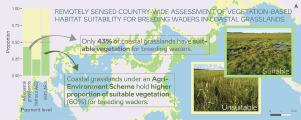
Coastal grasslands are semi-natural habitats used for agriculture, but they are also vital habitats for many taxa, such as waders. The importance of this habitat for wildlife has found recognition in the policies of the European Union, resulting in the implementation of biodiversity-friendly agri-environment schemes (AES) to ensure the sustainable management of these areas. However, the performance of AESs has often been questioned and data to analyse their effectiveness is mostly lacking.
To fill this knowledge gap, we used freely available European Space Agency's Sentinel-1 Synthetic Aperture Radar (SAR) images and ground truth data to describe the vegetation height based habitat suitability of coastal grasslands as breeding sites for waders at a country-wide scale in Estonia, where the main threat to this habitat is overgrowing with high sward plant species.
We show that satellite remote sensing can be used as a straight-forward and reliable tool to estimate the grazed coastal grassland habitat suitability for breeding waders in terms of vegetation height in two broad classes.
We demonstrate that the AES applied on Estonian coastal grasslands is important for improving the suitability of this habitat for the breeding wader community: compared to 24% of suitable habitat in areas where no agricultural subsidies are paid, 60% of the land under the targeted AES is suitably managed for breeding waders. The highest proportion of habitat suitability (76%) is achieved in areas receiving targeted top-up subsidy for wader conservation.
Continued monitoring of the performance of the AES is essential for taking timely and targeted conservation actions and we strongly recommend the wider use of remotely sensed data for this purpose. We promote the continuation of the AES scheme applied on Estonian coastal grasslands while improving its efficiency through carefully raised stocking rates and increased uptake of the top-up scheme.
中文翻译:
雷达遥感作为评估沿海草原农业环境计划绩效的新工具
沿海草原是用于农业的半自然栖息地,但它们也是许多分类群(如涉禽)的重要栖息地。这一野生动物栖息地的重要性已在欧盟政策中得到认可,从而实施了生物多样性友好型农业环境计划 (AES),以确保这些地区的可持续管理。然而,AES 的性能经常受到质疑,并且大多缺乏分析其有效性的数据。
为了填补这一知识空白,我们使用了免费提供的欧洲航天局的 Sentinel-1 合成孔径雷达 (SAR) 图像和地面实况数据来描述沿海草原在全国范围内作为涉水繁殖地的基于植被高度的栖息地适宜性。爱沙尼亚,对这个栖息地的主要威胁是高草植物物种过度生长。
我们表明,卫星遥感可以作为一种直接而可靠的工具,根据两大类的植被高度来估计放牧沿海草原栖息地对繁殖涉禽的适宜性。
我们证明了应用于爱沙尼亚沿海草原的 AES 对于提高该栖息地对繁殖涉禽社区的适宜性很重要:相比之下,在没有支付农业补贴的地区,适合栖息地的比例为 24%,目标 AES 下的土地比例为 60%适合繁殖涉禽。栖息地适宜性比例最高 (76%) 是在为涉禽保护接受定向补足补贴的地区实现的。
持续监测 AES 的性能对于及时和有针对性的保护行动至关重要,我们强烈建议为此目的更广泛地使用遥感数据。我们推动继续在爱沙尼亚沿海草原上应用 AES 计划,同时通过谨慎提高放养率和增加补充计划的采用来提高其效率。


 京公网安备 11010802027423号