International Journal of Disaster Risk Reduction ( IF 4.2 ) Pub Date : 2021-07-03 , DOI: 10.1016/j.ijdrr.2021.102434 Artan Hysa 1
|
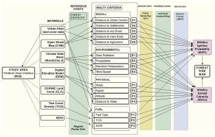
The main objective of this study is to push forward a rapid and cost-free method for forest fire proneness assessment within the wildland urban interface (WUI) for developing metropolitan areas. It compares between the forest surfaces within two capital regions from the Western Balkans (WB), namely Sarajevo and Tirana. This study follows a multi-criteria approach and integrates a variety of wildfire ignition or spreading causes relying on anthropogenic, hydro-meteorological, geophysical, and fuel properties of the study area. The indexing method utilizes specific techniques of data clustering and criteria weighting. The relative degree of implication that each criterion has with wildfire ignition and spreading behaviour is weighted via a hierarchical pairwise comparison (AHP) among criteria. The workflow is automated via graphical modeller in QGIS, making the method easily reproducible to other metropolitan areas in the developing regions. Relying on the map of wildfire spreading capacity index (WSCI), the study demonstrates a vulnerability analysis focusing on the exposed buildings. According to the results, Sarajevo has four times more exposed buildings than Tirana. However, the exposed buildings in Tirana record higher risk values than in Sarajevo. The sensitivity of the proposed indexing model is tested via Receiver Operating Characteristic (ROC) curve method, utilizing historical data on wildfire occurrences relying on the EFFIS database. The results of ROC analysis suggest that the relative weighted factors per each criteria are context-dependent, and must be calculated referring to local occurrences of wildfire. This study suggests that the urbanization and transportation network planning have a direct impact on the wildfire risk for the vegetated wildland urban interface (WUI). This study recommends the identification of wildfire-prone areas of metropolitan forest surfaces to be considered by policy-making bodies which are responsible for the disaster risk reduction at metropolitan level.
中文翻译:
通过野火点燃和蔓延能力对 WUI 内的植被表面进行索引,一个来自发展中大都市区的比较案例
本研究的主要目的是在开发大都市区的荒地城市界面 (WUI) 内推动一种快速且免费的森林火灾倾向评估方法。它比较了西巴尔干 (WB) 两个首都地区的森林表面,即萨拉热窝和地拉那。本研究遵循多标准方法,并根据研究区域的人为、水文气象、地球物理和燃料特性整合了各种野火点燃或蔓延的原因。索引方法利用数据聚类和标准加权的特定技术。每个标准对野火点燃和蔓延行为的相对影响程度通过标准之间的分层成对比较 (AHP) 进行加权。工作流程是通过 QGIS 中的图形建模器自动化的,使该方法易于复制到发展中地区的其他大都市地区。该研究依靠野火蔓延能力指数 (WSCI) 地图,展示了针对暴露建筑物的脆弱性分析。根据结果,萨拉热窝的裸露建筑是地拉那的四倍。然而,地拉那暴露在外的建筑物的风险值高于萨拉热窝。通过接收器操作特征 (ROC) 曲线方法,利用依赖于 EFFIS 数据库的野火发生的历史数据,对所提出的索引模型的敏感性进行了测试。ROC 分析的结果表明,每个标准的相对加权因子取决于上下文,必须参考当地发生的野火进行计算。本研究表明,城市化和交通网络规划对植被荒地城市界面 (WUI) 的野火风险有直接影响。本研究建议负责城市层面减少灾害风险的决策机构考虑确定城市森林表面的野火易发区域。


 京公网安备 11010802027423号