Journal of Asian Earth Sciences ( IF 2.7 ) Pub Date : 2021-06-30 , DOI: 10.1016/j.jseaes.2021.104880 Sean Cheong Heng Lee , Khairul Arifin Mohd Noh , Muhammad Noor Amin Zakariah
|
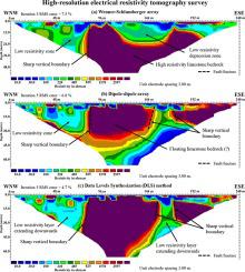
This research article describes the integration of high-resolution electrical resistivity tomography (ERT) and seismic refraction to explore potential groundwater in fracture carbonate hard rocks. Data Levels Synthesization (DLS) method is developed where the data levels of two different optimized arrays were merged to produce one final subsurface resistivity image to achieve high-resolution ERT. Numerical modeling was initially conducted on three different geoelectrical arrays. The results of before and after applied DLS method were compared to evaluate the effectiveness of each geoelectrical array to delineate fracture and anomalies accurately. Lineament map is constructed beforehand to map the major discontinuities which could possibly be the potential target for water-containing and water-conducting zones in the subsurface. Two geophysical survey lines were conducted where each survey line covered both ERT and seismic refraction methods. Two tube wells were successfully drilled exactly on the fracture zone with a flow rate around 1000 L/h. The potential water-containing zones within the subsurface limestone bedrock were identified as zones of low to moderate geoelectrical resistivity values ranging from 10 to 400 Ωm and Vp velocities exceeding 2000 ms−1. The fault zones were determined by sharp vertical boundary between the high and low resistivities zones in ERT image and lateral decrease in the Vp velocities of the limestone bedrock and depressions along the overburden-bedrock interface. The DLS method of Wenner-Schlumberger and dipole–dipole arrays had been proven effective in enhancing the horizontal and vertical resolutions to produce high-resolution ERT image validated with seismic refraction, lineament map, and tube well drillings.
中文翻译:
用于断裂硬岩中地下水勘探的高分辨率电阻率层析成像和地震折射:马来西亚霹雳州 Kanthan 的案例研究
这篇研究文章描述了高分辨率电阻率层析成像 (ERT) 和地震折射的集成,以探索断裂碳酸盐硬岩中的潜在地下水。开发了数据水平合成 (DLS) 方法,其中合并了两个不同优化阵列的数据水平以生成最终的地下电阻率图像,以实现高分辨率 ERT。数值模拟最初是在三个不同的地电阵列上进行的。比较应用DLS方法前后的结果,以评估每个地电阵列准确描绘裂缝和异常的有效性。线路图是预先构建的,以绘制可能成为地下含水和导水带潜在目标的主要不连续性。进行了两条地球物理勘测线,其中每条勘测线都涵盖了 ERT 和地震折射方法。在裂缝带上成功钻了两口管井,流速约为 1000 L/h。地下石灰岩基岩内的潜在含水带被确定为低至中等地电阻率值的区域,范围为 10 至 400 Ωm 和 Vp速度超过 2000 ms -1。断层带是由 ERT 图像中高低电阻率带之间明显的垂直边界以及沿覆盖-基岩界面的石灰岩基岩和凹陷的 V p速度横向减小确定的。Wenner-Schlumberger 和偶极-偶极阵列的 DLS 方法已被证明可有效提高水平和垂直分辨率,以产生经地震折射、线性图和管井钻探验证的高分辨率 ERT 图像。


 京公网安备 11010802027423号