Journal of Asian Earth Sciences ( IF 2.7 ) Pub Date : 2021-06-30 , DOI: 10.1016/j.jseaes.2021.104877 Khayingshing Luirei , Kapesa Lokho , Limasanen Longkumer , Girish Ch. Kothyari , Ritu Rai , Ishwar S. Rawat , Diezevisie Nakhro
|
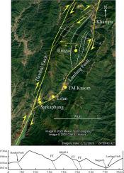
The present study is an attempt to gain insight of the geodynamic implications on the evolution of Quaternary landforms in the Yangui River basin in the Indo-Myanmar Range (IMR), taking a multi-disciplinary approach. Originating at an elevation of ~2568 m asl, the Yangui River flows almost parallel to the regional strike of the IMR and drains into the Imphal valley at Yaripok and exhibits varied valley floor morphology. The valley floors are narrowest in the transverse valley sections. The fluvial landforms are represented by fill terraces, strath terraces and paleochannels. The chronologically constrained ages from fluvial stratigraphy suggests that the oldest phase of aggradation in the area began much before 8 ka. A total of 1164 lineaments were mapped, most trending NE-SW, which is slightly oblique to the regional strike of the IMR. East of the study area, the most prominent lineaments are those trending NE-SW. Lineament analysis suggests that the NNE-SSW trending lineaments are the first generation; followed by the ENE-SWS, while the youngest are the NW-SE trending lineaments. Quaternary landforms related to tectonic activity are observed in the Ringui area, where the morphology suggests transpressional tectonics. Cross-cutting relationships amongst faults suggest multiple phases of tectonic activity; linear valleys are observed along the fault planes. The cross conjugate faults and NW-SW lineaments of the area confirm tectonic activity in the area, which corroborates well with the seismogenic potential and oblique geometry of the Churachandpur-Mao Fault (CMF). Morphometric data also suggest ongoing tectonic activity in the area.
中文翻译:
印缅山脉延吉河流域第四纪地貌构造演化
本研究试图通过多学科方法深入了解印度-缅甸山脉 (IMR) 延吉河流域第四纪地貌演化的地球动力学影响。扬吉河起源于海拔约 2568 米,几乎平行于 IMR 的区域走向,流入 Yaripok 的英帕尔河谷,呈现出不同的谷底形态。谷底在横向谷段中最窄。河流地貌以充填阶地、地层阶地和古河道为代表。河流地层按时间顺序限制的年龄表明该地区最古老的加成阶段在 8 ka 之前就开始了。总共绘制了 1164 条线路,最趋向于 NE-SW,与 IMR 的区域走向略有倾斜。在研究区以东,最突出的线条是那些趋向 NE-SW 的线条。线条分析表明,NNE-SSW 趋势线条是第一代;其次是 ENE-SWS,而最年轻的是 NW-SE 趋势线。在林吉地区观察到与构造活动有关的第四纪地貌,其形态表明具有挤压构造。断层之间的交叉关系表明构造活动的多个阶段;沿断层面观察到线性谷。该地区的交叉共轭断层和 NW-SW 线条证实了该地区的构造活动,这很好地证实了 Churachandpur-Mao 断层 (CMF) 的地震潜力和倾斜几何形状。形态测量数据还表明该地区正在进行构造活动。最突出的线条是那些趋向 NE-SW 的线条。线条分析表明,NNE-SSW 趋势线条是第一代;其次是 ENE-SWS,而最年轻的是 NW-SE 趋势线。在林吉地区观察到与构造活动有关的第四纪地貌,其形态表明具有挤压构造。断层之间的交叉关系表明构造活动的多个阶段;沿断层面观察到线性谷。该地区的交叉共轭断层和 NW-SW 线条证实了该地区的构造活动,这很好地证实了 Churachandpur-Mao 断层 (CMF) 的地震潜力和倾斜几何形状。形态测量数据还表明该地区正在进行构造活动。最突出的线条是那些趋向 NE-SW 的线条。线条分析表明,NNE-SSW 趋势线条是第一代;其次是 ENE-SWS,而最年轻的是 NW-SE 趋势线。在林吉地区观察到与构造活动有关的第四纪地貌,其形态表明具有挤压构造。断层之间的交叉关系表明构造活动的多个阶段;沿断层面观察到线性谷。该地区的交叉共轭断层和 NW-SW 线条证实了该地区的构造活动,这很好地证实了 Churachandpur-Mao 断层 (CMF) 的地震潜力和倾斜几何形状。形态测量数据还表明该地区正在进行构造活动。线条分析表明,NNE-SSW 趋势线条是第一代;其次是 ENE-SWS,而最年轻的是 NW-SE 趋势线。在林吉地区观察到与构造活动有关的第四纪地貌,其形态表明具有挤压构造。断层之间的交叉关系表明构造活动的多个阶段;沿断层面观察到线性谷。该地区的交叉共轭断层和 NW-SW 线条证实了该地区的构造活动,这很好地证实了 Churachandpur-Mao 断层 (CMF) 的地震潜力和倾斜几何形状。形态测量数据还表明该地区正在进行构造活动。线条分析表明,NNE-SSW 趋势线条是第一代;其次是 ENE-SWS,而最年轻的是 NW-SE 趋势线。在林吉地区观察到与构造活动有关的第四纪地貌,其形态表明具有挤压构造。断层之间的交叉关系表明构造活动的多个阶段;沿断层面观察到线性谷。该地区的交叉共轭断层和 NW-SW 线条证实了该地区的构造活动,这很好地证实了 Churachandpur-Mao 断层 (CMF) 的地震潜力和倾斜几何形状。形态测量数据还表明该地区正在进行构造活动。在林吉地区观察到与构造活动有关的第四纪地貌,其形态表明具有挤压构造。断层之间的交叉关系表明构造活动的多个阶段;沿断层面观察到线性谷。该地区的交叉共轭断层和 NW-SW 线条证实了该地区的构造活动,这很好地证实了 Churachandpur-Mao 断层 (CMF) 的地震潜力和倾斜几何形状。形态测量数据还表明该地区正在进行构造活动。在林吉地区观察到与构造活动有关的第四纪地貌,其形态表明具有挤压构造。断层之间的交叉关系表明构造活动的多个阶段;沿断层面观察到线性谷。该地区的交叉共轭断层和 NW-SW 线条证实了该地区的构造活动,这很好地证实了 Churachandpur-Mao 断层 (CMF) 的地震潜力和倾斜几何形状。形态测量数据还表明该地区正在进行构造活动。该地区的交叉共轭断层和 NW-SW 线条证实了该地区的构造活动,这很好地证实了 Churachandpur-Mao 断层 (CMF) 的地震潜力和倾斜几何形状。形态测量数据还表明该地区正在进行构造活动。该地区的交叉共轭断层和 NW-SW 线条证实了该地区的构造活动,这很好地证实了 Churachandpur-Mao 断层 (CMF) 的地震潜力和倾斜几何形状。形态测量数据还表明该地区正在进行构造活动。


 京公网安备 11010802027423号