当前位置:
X-MOL 学术
›
Earth Surf.Process. Land.
›
论文详情
Our official English website, www.x-mol.net, welcomes your
feedback! (Note: you will need to create a separate account there.)
Remote sensing of large wood in high-resolution satellite imagery: Design of an automated classification work-flow for multiple wood deposit types
Earth Surface Processes and Landforms ( IF 2.8 ) Pub Date : 2021-06-28 , DOI: 10.1002/esp.5179 Alicia Sendrowski 1, 2 , Ellen Wohl 1
Earth Surface Processes and Landforms ( IF 2.8 ) Pub Date : 2021-06-28 , DOI: 10.1002/esp.5179 Alicia Sendrowski 1, 2 , Ellen Wohl 1
Affiliation
|
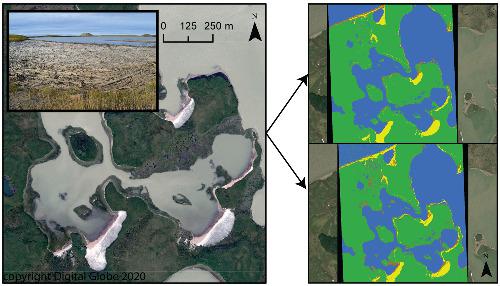
Wood researchers increasingly rely on remote-sensing products to augment field information about wood deposits in river corridors. The availability of very high-resolution (<1 m) satellite imagery makes capturing wood over greater spatial extents possible, but previous studies have found difficulty in automatically extracting wood deposits due to the challenge in distinguishing wood from spectrally similar corridor features such as sand. We also lack knowledge on the spectral properties of different wood deposit types in multiple depositional environments. In this work, we explore image classification work-flows for four wood deposit types in three North American environments: in-channel jams deposited in the Tatshenshini River in Alaska, USA; a wood raft on the Slave River in Northwest Territories, Canada; and wood deposited along a lakeshore and coastal embayment in the Mackenzie River Delta in Northwest Territories, Canada. We compare classification results of object-based and pixel-based image analysis with supervised [support vector machine (SVM)] and unsupervised (ISO clustering) classifiers. We evaluate several accuracy assessment parameters and achieve overall classification accuracies of 65–99%, showing automated image classification is a possible approach for analysing wood across larger areas. We also find that wood sensitivity in the classification ranged from 0 to 95%, indicating that some techniques are better suited to wood capture than others. We find that supervised classification produced more accurate wood maps, though there is large variation in classification outcomes across environments related to spatial arrangement of wood in the landscape. We discuss the influence of depositional environment on classification and provide recommendations for designing a wood classification work-flow.
中文翻译:

高分辨率卫星图像中大木材的遥感:多种木材沉积类型的自动分类工作流程的设计
木材研究人员越来越依赖遥感产品来增加有关河流走廊木材沉积的实地信息。超高分辨率 (<1 m) 卫星图像的可用性使得在更大的空间范围内捕获木材成为可能,但之前的研究发现,由于难以将木材与光谱相似的走廊特征(如沙子)区分开来,因此很难自动提取木材沉积物。我们还缺乏对多种沉积环境中不同木材沉积类型的光谱特性的了解。在这项工作中,我们探索了北美三种环境中四种木材沉积类型的图像分类工作流程:沉积在美国阿拉斯加 Tatshenshini 河的河道内堵塞;加拿大西北地区奴隶河上的木筏;以及沿着加拿大西北地区麦肯齐河三角洲的湖岸和沿海海湾沉积的木材。我们将基于对象和基于像素的图像分析的分类结果与有监督的 [支持向量机 (SVM)] 和无监督的 (ISO 聚类) 分类器进行比较。我们评估了几个准确度评估参数并实现了 65-99% 的整体分类准确度,表明自动图像分类是一种可能的方法来分析更大区域的木材。我们还发现分类中的木材敏感性介于 0 到 95% 之间,这表明某些技术比其他技术更适合木材捕获。我们发现监督分类产生了更准确的木材图,尽管与景观中木材的空间排列相关的环境之间的分类结果存在很大差异。我们讨论沉积环境对分类的影响,并为设计木材分类工作流程提供建议。
更新日期:2021-06-28
中文翻译:
高分辨率卫星图像中大木材的遥感:多种木材沉积类型的自动分类工作流程的设计
木材研究人员越来越依赖遥感产品来增加有关河流走廊木材沉积的实地信息。超高分辨率 (<1 m) 卫星图像的可用性使得在更大的空间范围内捕获木材成为可能,但之前的研究发现,由于难以将木材与光谱相似的走廊特征(如沙子)区分开来,因此很难自动提取木材沉积物。我们还缺乏对多种沉积环境中不同木材沉积类型的光谱特性的了解。在这项工作中,我们探索了北美三种环境中四种木材沉积类型的图像分类工作流程:沉积在美国阿拉斯加 Tatshenshini 河的河道内堵塞;加拿大西北地区奴隶河上的木筏;以及沿着加拿大西北地区麦肯齐河三角洲的湖岸和沿海海湾沉积的木材。我们将基于对象和基于像素的图像分析的分类结果与有监督的 [支持向量机 (SVM)] 和无监督的 (ISO 聚类) 分类器进行比较。我们评估了几个准确度评估参数并实现了 65-99% 的整体分类准确度,表明自动图像分类是一种可能的方法来分析更大区域的木材。我们还发现分类中的木材敏感性介于 0 到 95% 之间,这表明某些技术比其他技术更适合木材捕获。我们发现监督分类产生了更准确的木材图,尽管与景观中木材的空间排列相关的环境之间的分类结果存在很大差异。我们讨论沉积环境对分类的影响,并为设计木材分类工作流程提供建议。


 京公网安备 11010802027423号