当前位置:
X-MOL 学术
›
Earth Surf.Process. Land.
›
论文详情
Our official English website, www.x-mol.net, welcomes your
feedback! (Note: you will need to create a separate account there.)
Evaluating the geomorphic channel response to beaver dam analog installation using unoccupied aerial vehicles
Earth Surface Processes and Landforms ( IF 2.8 ) Pub Date : 2021-06-28 , DOI: 10.1002/esp.5180 Julianne Davis 1, 2 , Laura Lautz 3 , Christa Kelleher 4, 5 , Philippe Vidon 6 , Christopher Russoniello 7 , Casey Pearce 6
Earth Surface Processes and Landforms ( IF 2.8 ) Pub Date : 2021-06-28 , DOI: 10.1002/esp.5180 Julianne Davis 1, 2 , Laura Lautz 3 , Christa Kelleher 4, 5 , Philippe Vidon 6 , Christopher Russoniello 7 , Casey Pearce 6
Affiliation
|
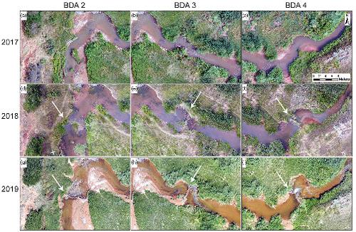
Beaver dam analogs (BDAs) are a stream restoration technique that is rapidly gaining popularity in the western United States. These low-cost, stream-spanning structures, designed after natural beaver dams, are being installed to confer the ecologic, hydrologic, and geomorphic benefits of beaver dams in streams that are often too degraded to provide suitable beaver habitat. BDAs are intended to slow streamflow, reduce the erosive power of the stream, and promote aggradation, making them attractive restoration tools in incised channels. Despite increasing adoption of BDAs, few studies to date have monitored the impacts of BDAs on channel form. Here, we examine the geomorphic changes that occurred within the first year of restoration efforts in Wyoming using high-resolution visible light orthomosaics and elevation data collected with unoccupied aerial vehicles (UAVs). By leveraging the advantages of rapidly acquired images from UAV surveys with recent advancements in structure-from-motion photogrammetry, we constructed centimeter-scale digital elevation models (DEMs) of the restoration reach and an upstream control reach. Through DEM differencing, we identified areas of enhanced erosion and deposition near the BDAs, suggesting BDA installation initiated a unique geomorphic response in the channel. Both reaches were characterized by net erosion during the first year of restoration efforts. While erosion around the BDAs may seem counter to the long-term goal of BDA-induced aggradation, short-term net erosion is consistent with high precipitation during the study and with theoretical channel evolution models of beaver-related stream restoration that predict initial channel widening and erosion before net deposition. To better understand the impacts of BDAs on channel morphology and restoration efforts in the western United States, it is imperative that we consistently assess the effects of beaver-inspired restoration projects across a range of hydrologic and geomorphic settings and that we continue this monitoring in the future.
中文翻译:

使用无人飞行器评估海狸坝模拟装置的地貌通道响应
海狸坝类似物 (BDAs) 是一种溪流恢复技术,在美国西部迅速普及。这些低成本、跨河流的结构是根据天然海狸水坝设计的,正在安装以赋予河狸水坝的生态、水文和地貌优势,这些溪流通常退化得太厉害,无法提供合适的海狸栖息地。BDA 旨在减缓水流,降低水流的侵蚀力,并促进聚集,使其成为切割通道中有吸引力的修复工具。尽管越来越多地采用 BDAs,但迄今为止很少有研究监测 BDAs 对渠道形式的影响。这里,我们使用高分辨率可见光正射镶嵌技术和无人飞行器 (UAV) 收集的高程数据,研究了怀俄明州恢复工作第一年发生的地貌变化。通过利用无人机调查快速获取图像的优势以及运动摄影测量结构的最新进展,我们构建了恢复范围和上游控制范围的厘米级数字高程模型 (DEM)。通过 DEM 差分,我们确定了 BDAs 附近侵蚀和沉积增强的区域,表明 BDA 安装在通道中引发了独特的地貌响应。在恢复工作的第一年,这两个河段的特点是净侵蚀。虽然 BDAs 周围的侵蚀似乎与 BDA 诱导的聚集的长期目标背道而驰,短期净侵蚀与研究期间的高降水以及海狸相关河流恢复的理论河道演化模型一致,该模型预测净沉积前的初始河道加宽和侵蚀。为了更好地了解 BDAs 对美国西部河道形态和修复工作的影响,我们必须始终如一地评估一系列水文和地貌环境中受海狸启发的修复项目的影响,并在未来。
更新日期:2021-06-28
中文翻译:
使用无人飞行器评估海狸坝模拟装置的地貌通道响应
海狸坝类似物 (BDAs) 是一种溪流恢复技术,在美国西部迅速普及。这些低成本、跨河流的结构是根据天然海狸水坝设计的,正在安装以赋予河狸水坝的生态、水文和地貌优势,这些溪流通常退化得太厉害,无法提供合适的海狸栖息地。BDA 旨在减缓水流,降低水流的侵蚀力,并促进聚集,使其成为切割通道中有吸引力的修复工具。尽管越来越多地采用 BDAs,但迄今为止很少有研究监测 BDAs 对渠道形式的影响。这里,我们使用高分辨率可见光正射镶嵌技术和无人飞行器 (UAV) 收集的高程数据,研究了怀俄明州恢复工作第一年发生的地貌变化。通过利用无人机调查快速获取图像的优势以及运动摄影测量结构的最新进展,我们构建了恢复范围和上游控制范围的厘米级数字高程模型 (DEM)。通过 DEM 差分,我们确定了 BDAs 附近侵蚀和沉积增强的区域,表明 BDA 安装在通道中引发了独特的地貌响应。在恢复工作的第一年,这两个河段的特点是净侵蚀。虽然 BDAs 周围的侵蚀似乎与 BDA 诱导的聚集的长期目标背道而驰,短期净侵蚀与研究期间的高降水以及海狸相关河流恢复的理论河道演化模型一致,该模型预测净沉积前的初始河道加宽和侵蚀。为了更好地了解 BDAs 对美国西部河道形态和修复工作的影响,我们必须始终如一地评估一系列水文和地貌环境中受海狸启发的修复项目的影响,并在未来。


 京公网安备 11010802027423号