当前位置:
X-MOL 学术
›
Remote Sens. Ecol. Conserv.
›
论文详情
Our official English website, www.x-mol.net, welcomes your
feedback! (Note: you will need to create a separate account there.)
Interpolating missing land cover data using stochastic spatial random forests for improved change detection
Remote Sensing in Ecology and Conservation ( IF 3.9 ) Pub Date : 2021-06-27 , DOI: 10.1002/rse2.221 Jacinta Holloway‐Brown 1 , Kate J. Helmstedt 1 , Kerrie L. Mengersen 1
Remote Sensing in Ecology and Conservation ( IF 3.9 ) Pub Date : 2021-06-27 , DOI: 10.1002/rse2.221 Jacinta Holloway‐Brown 1 , Kate J. Helmstedt 1 , Kerrie L. Mengersen 1
Affiliation
|
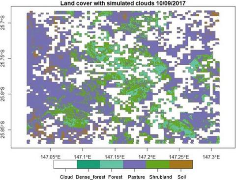
Forest cover requires large scale and frequent monitoring as an indicator of biodiversity and progress towards United Nations and World Bank Sustainable Development Goal 15. Measuring change in forest cover over time is an essential task in order to track and preserve quality habitats for species around the world. Due to the prohibitive expense and impracticality of mass field data collection to monitor forest cover at regular intervals, satellite images are a key data source for monitoring forest cover globally. A challenge of working with satellite images is missing data due to clouds. Existing methods for interpolating the missing data based on past images, such as compositing, are effective for stable land cover but can be inaccurate for dynamic and substantially changing landscapes. Here we present an adaptation of our recent stochastic spatial random forest (SS-RF) method, which combines observed data from a prior image and modelled estimates of the current image to produce interpolated land cover values and associated probabilities of those values. Results show our SS-RF method accurately detected simulated land cover change under both clear felling (0.83 average overall accuracy) and tree thinning (0.85 average overall accuracy). Our method detected forest cover change substantially more accurately than compositing, offering 39% and 12% increases in average overall accuracy for clear felling and tree thinning simulations respectively. However, when natural fluctuation occurs and there is minimal change in land cover, compositing has equivalent or more accurate performance than our method. Overall we find that our SS-RF method produces accurate estimates under a range of simulated forest clearing scenarios and has a more accurate and robust performance than compositing when modelling noticeably changing landscapes.
中文翻译:

使用随机空间随机森林对缺失的土地覆盖数据进行插值以改进变化检测
森林覆盖需要大规模和频繁监测,作为生物多样性和实现联合国和世界银行可持续发展目标 15 进展的指标。衡量森林覆盖随时间的变化是跟踪和保护世界各地物种优质栖息地的一项基本任务. 由于定期收集大量现场数据以监测森林覆盖率的成本高昂且不切实际,因此卫星图像是监测全球森林覆盖率的关键数据源。处理卫星图像的一个挑战是由于云而丢失数据。现有的基于过去图像对缺失数据进行插值的方法(例如合成)对于稳定的土地覆盖是有效的,但对于动态和显着变化的景观可能不准确。在这里,我们提出了对我们最近的随机空间随机森林 (SS-RF) 方法的改编,该方法结合了来自先前图像的观察数据和当前图像的建模估计,以产生插值的土地覆盖值和这些值的相关概率。结果表明,我们的 SS-RF 方法准确地检测了在砍伐(0.83 平均总体准确度)和树木间伐(0.85 平均总体准确度)下模拟的土地覆盖变化。我们的方法比合成更准确地检测到森林覆盖变化,在砍伐和树木间伐模拟的平均总体准确度上分别提高了 39% 和 12%。然而,当发生自然波动并且土地覆盖变化很小时,合成具有与我们的方法相同或更准确的性能。
更新日期:2021-06-27
中文翻译:
使用随机空间随机森林对缺失的土地覆盖数据进行插值以改进变化检测
森林覆盖需要大规模和频繁监测,作为生物多样性和实现联合国和世界银行可持续发展目标 15 进展的指标。衡量森林覆盖随时间的变化是跟踪和保护世界各地物种优质栖息地的一项基本任务. 由于定期收集大量现场数据以监测森林覆盖率的成本高昂且不切实际,因此卫星图像是监测全球森林覆盖率的关键数据源。处理卫星图像的一个挑战是由于云而丢失数据。现有的基于过去图像对缺失数据进行插值的方法(例如合成)对于稳定的土地覆盖是有效的,但对于动态和显着变化的景观可能不准确。在这里,我们提出了对我们最近的随机空间随机森林 (SS-RF) 方法的改编,该方法结合了来自先前图像的观察数据和当前图像的建模估计,以产生插值的土地覆盖值和这些值的相关概率。结果表明,我们的 SS-RF 方法准确地检测了在砍伐(0.83 平均总体准确度)和树木间伐(0.85 平均总体准确度)下模拟的土地覆盖变化。我们的方法比合成更准确地检测到森林覆盖变化,在砍伐和树木间伐模拟的平均总体准确度上分别提高了 39% 和 12%。然而,当发生自然波动并且土地覆盖变化很小时,合成具有与我们的方法相同或更准确的性能。


 京公网安备 11010802027423号