当前位置:
X-MOL 学术
›
Geolog. J.
›
论文详情
Our official English website, www.x-mol.net, welcomes your
feedback! (Note: you will need to create a separate account there.)
Assessment of irrigational indices in surface water and shallow groundwater in the alluvial plain of Barak Valley, Assam, Northeast India
Geological Journal ( IF 1.4 ) Pub Date : 2021-06-24 , DOI: 10.1002/gj.4198 Khangembam Sharmila Devi 1 , Kshetrimayum Krishnakanta Singh 2
Geological Journal ( IF 1.4 ) Pub Date : 2021-06-24 , DOI: 10.1002/gj.4198 Khangembam Sharmila Devi 1 , Kshetrimayum Krishnakanta Singh 2
Affiliation
|
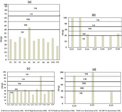
The main sources of water resources of the Barak Valley of Northeast India for irrigation are the surface water bodies in the form of ponds, lakes, rivers, and groundwater. This paper elucidates insight into the irrigational parameters to classify the types of water, based on these indices. Total hardness shows that 90% of surface water belongs to the soft and 63% of groundwater samples belong to the soft category. C-S plot shows 33% of surface water belongs to C1-S1 and 66% of groundwater samples belongs to C1-S1 and C2-S1, indicating fresh and suitable for use. The percentage Na+ shows most samples belong to good and permissible categories. Permeability index shows 81% of surface water in Class II and 18% in Class III, indicating good and bad types, respectively. Kelly's index suggests 90% of surface water is suitable and 9% is unsuitable, while 14% of piedmont groundwater is unsuitable. Magnesium hazard reveals 18% of surface water has more than 50 Magnesium absorptio ratio, leading to unsuitable, while 28% of piedmont and 33% of flood plain groundwater samples belong to unsuitable. Residual sodium carbon suggests surface water as suitable, while 48%, 12%, and 6% of groundwater belong to suitable, marginal, and unsuitable categories, respectively. Irrigation Water Quality Index values indicate that surface water is characterized by a highly restricted class, as they are exposed to surficial contamination as compared to groundwater. Base exchange index of ions indicates Na+-SO4−2 hydro-facies type suggesting dissolution of salt minerals in weak acidic water. Meteoric genesis index of ions reveals the source of groundwater as deeper meteoric water. Thus, the present study indices that the surface water bodies such as ponds, lakes, and swamps are more prone to contamination, leading to unsuitability for irrigational use, as compared to shallow groundwater in the study area, and therefore, appropriate measures must be adopted to reduce the quality deterioration for maximum utilization.
中文翻译:

印度东北部阿萨姆邦巴拉克谷冲积平原地表水和浅层地下水灌溉指数的评估
印度东北部巴拉克河谷灌溉用水的主要来源是池塘、湖泊、河流和地下水形式的地表水体。本文阐明了对灌溉参数的深入了解,以根据这些指标对水的类型进行分类。总硬度表明,90%的地表水属于软水,63%的地下水样品属于软水。CS图显示33%的地表水属于C1-S1,66%的地下水样品属于C1-S1和C2-S1,表明新鲜,适合使用。Na +百分比表明大多数样本属于良好和允许的类别。渗透率指数显示,地表水为Ⅱ类81%,Ⅲ类为18%,分别表示好类型和坏类型。Kelly 的指数表明 90% 的地表水是合适的,9% 是不合适的,而 14% 的山前地下水是不合适的。镁危害揭示18%的地表水镁吸收比大于50,导致不适宜,而28%的山前和33%的洪泛平原地下水样品属于不适宜。残留钠碳表明地表水是合适的,而地下水的 48%、12% 和 6% 分别属于合适、边缘和不合适的类别。灌溉水质指数值表明地表水具有高度受限的等级,因为与地下水相比,它们暴露于地表污染。离子的碱基交换指数表示 Na+ -SO 4 -2水相类型表明盐矿物在弱酸性水中溶解。离子成因指数揭示地下水的来源为较深的大气水。因此,本研究表明,与研究区浅层地下水相比,池塘、湖泊和沼泽等地表水体更容易受到污染,导致不适合灌溉使用,因此必须采取适当的措施。以减少质量劣化以实现最大利用率。
更新日期:2021-06-24
中文翻译:
印度东北部阿萨姆邦巴拉克谷冲积平原地表水和浅层地下水灌溉指数的评估
印度东北部巴拉克河谷灌溉用水的主要来源是池塘、湖泊、河流和地下水形式的地表水体。本文阐明了对灌溉参数的深入了解,以根据这些指标对水的类型进行分类。总硬度表明,90%的地表水属于软水,63%的地下水样品属于软水。CS图显示33%的地表水属于C1-S1,66%的地下水样品属于C1-S1和C2-S1,表明新鲜,适合使用。Na +百分比表明大多数样本属于良好和允许的类别。渗透率指数显示,地表水为Ⅱ类81%,Ⅲ类为18%,分别表示好类型和坏类型。Kelly 的指数表明 90% 的地表水是合适的,9% 是不合适的,而 14% 的山前地下水是不合适的。镁危害揭示18%的地表水镁吸收比大于50,导致不适宜,而28%的山前和33%的洪泛平原地下水样品属于不适宜。残留钠碳表明地表水是合适的,而地下水的 48%、12% 和 6% 分别属于合适、边缘和不合适的类别。灌溉水质指数值表明地表水具有高度受限的等级,因为与地下水相比,它们暴露于地表污染。离子的碱基交换指数表示 Na+ -SO 4 -2水相类型表明盐矿物在弱酸性水中溶解。离子成因指数揭示地下水的来源为较深的大气水。因此,本研究表明,与研究区浅层地下水相比,池塘、湖泊和沼泽等地表水体更容易受到污染,导致不适合灌溉使用,因此必须采取适当的措施。以减少质量劣化以实现最大利用率。


 京公网安备 11010802027423号