Anthropocene ( IF 3.3 ) Pub Date : 2021-06-23 , DOI: 10.1016/j.ancene.2021.100300 Kathryn Russell
|
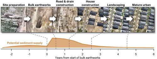
Residential construction is among the most intensive land disturbance activities in cities, increasing runoff and sediment export. In growing cities, large-scale residential construction areas are ubiquitous on the city fringes, but their relative contribution to city-wide land disturbance patterns is unknown. So is the relative sediment supply potential of different phases of construction. Such insights are required to guide prioritisation of sediment management measures at both city and development scales. A multi-scale assessment was therefore undertaken of land development spatial and temporal patterns. The assessment used remotely-sensed elevation data to characterise earthworks intensity and extent across different zones of a large city (Melbourne, Australia), and fine-scale aerial imagery surveys of bare soil and impervious cover to characterise watershed disturbance over time in new construction areas. Earthworks extent and intensity were greatest in outer growth areas where they were dominated by residential construction. Within residential developments, soil disturbance and drainage alteration proceeded in a consistent temporal sequence, lasting around 4–9 years in total. Bare soil cover approached 100 % during bulk earthworks. A conceptual model of changes in potential runoff and sediment supply over a series of construction phases suggests that potential sediment supply peaks with bare soil cover, but then remains high during subsequent road and house construction as imperviousness and drainage connection increase. Policies to reduce sediment loads to streams and receiving waters should place greater priority on improving construction erosion and sediment control in growth areas, and should target both development-scale and lot-scale activities. The conceptual model developed here provides a generalised hypothesis which could guide monitoring studies to target relevant construction phases at a fine temporal resolution and spatial scale.
中文翻译:
与绿地住宅建设相关的潜在沉积物供应通量
住宅建设是城市中最密集的土地扰动活动之一,增加了径流和泥沙的输出。在不断发展的城市中,大规模的住宅建筑区在城市边缘无处不在,但它们对全市土地扰动模式的相对贡献尚不清楚。不同施工阶段的相对沉积物供应潜力也是如此。需要这些见解来指导城市和发展规模的沉积物管理措施的优先顺序。因此,对土地开发时空格局进行了多尺度评估。评估使用遥感高程数据来描述一个大城市(澳大利亚墨尔本)不同区域的土方工程强度和范围,以及裸露土壤和不透水覆盖层的精细航空影像调查,以表征新建筑区域随时间推移的流域干扰。土方工程的范围和强度在以住宅建筑为主的外围增长区最大。在住宅开发中,土壤扰动和排水改造以一致的时间顺序进行,总共持续了大约 4-9 年。在大宗土方工程期间,裸土覆盖率接近 100%。一系列施工阶段潜在径流和沉积物供应变化的概念模型表明,潜在沉积物供应在裸土覆盖时达到峰值,但在随后的道路和房屋建设中随着不透水和排水连接的增加而保持高位。减少河流和受纳水体沉积物负荷的政策应更加重视改善生长区的建筑侵蚀和沉积物控制,并应针对开发规模和批次规模的活动。这里开发的概念模型提供了一个广义假设,可以指导监测研究以精细的时间分辨率和空间尺度针对相关施工阶段。


 京公网安备 11010802027423号