当前位置:
X-MOL 学术
›
Hydrol. Process.
›
论文详情
Our official English website, www.x-mol.net, welcomes your
feedback! (Note: you will need to create a separate account there.)
Smoothing of digital elevation models and the alteration of overland flow path length distributions
Hydrological Processes ( IF 2.8 ) Pub Date : 2021-06-23 , DOI: 10.1002/hyp.14271 Nigel Van Nieuwenhuizen 1 , John B. Lindsay 1 , Ben DeVries 1
Hydrological Processes ( IF 2.8 ) Pub Date : 2021-06-23 , DOI: 10.1002/hyp.14271 Nigel Van Nieuwenhuizen 1 , John B. Lindsay 1 , Ben DeVries 1
Affiliation
|
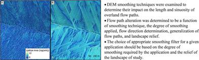
DEM smoothing is a common pre-processing technique used to remove undesirable roughness from a DEM. However, it is hypothesized that smoothing straightens and reduces the length of overland flow paths, which is an important factor controlling modelled time-to-peak flow. Currently, there is a lack of research comparing how different smoothing techniques alter the distribution of overland flow path length. Four low-pass filtering techniques were applied to three fine-resolution LiDAR DEMs of varying relief: the mean filter, the median filter, the Gaussian filter, and the feature-preserving DEM smoothing (FPDEMS) filter, each with different degrees of smoothing. Downslope-distance-to-stream distributions were then derived using D8 and D∞ flow directions and statistically compared to distributions derived from the unsmoothed DEM for each study site. The results indicate that the alteration of flow path length distributions as a result of smoothing is complex. Mean flow path lengths may decrease or increase in response to smoothing, depending on landscape relief and the derivation of flow directions, and generalized flow paths may become longer. The largest increase in mean flow path lengths was 19.2 m using the 21 × 21 median filter and D8 flow directions in the high-relief study site, relative to an unsmoothed mean length of 138.6 m in this site. The largest decrease in mean flow path length was 48.9 m using the 21 × 21 mean filter and D∞ flow directions in the low-relief study site, relative to an unsmoothed mean length of 290.9 m in this site. Furthermore, minimal flow path length alterations were achieved with the Gaussian filter when gentle smoothing is required, and with the FPDEMS filter when moderate to aggressive smoothing is required. These results suggest that an appropriate smoothing method should be chosen based on the relief of the landscape and the degree of smoothing required.
中文翻译:

数字高程模型的平滑和地表径流路径长度分布的改变
DEM 平滑是一种常用的预处理技术,用于从 DEM 中去除不需要的粗糙度。然而,假设平滑可以拉直并减少地表流动路径的长度,这是控制模拟的到达峰值流的时间的一个重要因素。目前,缺乏比较不同平滑技术如何改变地表流路径长度分布的研究。四种低通滤波技术应用于三种不同浮雕的精细分辨率 LiDAR DEM:均值滤波器、中值滤波器、高斯滤波器和特征保留 DEM 平滑 (FPDEMS) 滤波器,每种滤波器都有不同程度的平滑。然后使用 D8 和 D∞ 流向导出下坡距离到河流的分布,并与每个研究站点的未平滑 DEM 导出的分布进行统计比较。结果表明,平滑导致的流路长度分布的改变是复杂的。平均流动路径长度可能会随着平滑而减少或增加,这取决于景观起伏和流动方向的推导,并且广义流动路径可能会变得更长。相对于该站点未平滑平均长度 138.6 m,使用 21 × 21 中值滤波器和 D8 流向在高浮雕研究站点中平均流动路径长度的最大增加为 19.2 m。相对于该站点未平滑平均长度 290.9 m,在低地势研究站点使用 21 × 21 平均滤波器和 D∞ 流向,平均流动路径长度的最大减少为 48.9 m。此外,当需要温和平滑时,使用高斯滤波器实现了最小的流路长度变化,当需要中度到积极的平滑时,使用 FPDEMS 过滤器。这些结果表明,应根据景观的起伏和所需的平滑程度选择合适的平滑方法。
更新日期:2021-07-06
中文翻译:
数字高程模型的平滑和地表径流路径长度分布的改变
DEM 平滑是一种常用的预处理技术,用于从 DEM 中去除不需要的粗糙度。然而,假设平滑可以拉直并减少地表流动路径的长度,这是控制模拟的到达峰值流的时间的一个重要因素。目前,缺乏比较不同平滑技术如何改变地表流路径长度分布的研究。四种低通滤波技术应用于三种不同浮雕的精细分辨率 LiDAR DEM:均值滤波器、中值滤波器、高斯滤波器和特征保留 DEM 平滑 (FPDEMS) 滤波器,每种滤波器都有不同程度的平滑。然后使用 D8 和 D∞ 流向导出下坡距离到河流的分布,并与每个研究站点的未平滑 DEM 导出的分布进行统计比较。结果表明,平滑导致的流路长度分布的改变是复杂的。平均流动路径长度可能会随着平滑而减少或增加,这取决于景观起伏和流动方向的推导,并且广义流动路径可能会变得更长。相对于该站点未平滑平均长度 138.6 m,使用 21 × 21 中值滤波器和 D8 流向在高浮雕研究站点中平均流动路径长度的最大增加为 19.2 m。相对于该站点未平滑平均长度 290.9 m,在低地势研究站点使用 21 × 21 平均滤波器和 D∞ 流向,平均流动路径长度的最大减少为 48.9 m。此外,当需要温和平滑时,使用高斯滤波器实现了最小的流路长度变化,当需要中度到积极的平滑时,使用 FPDEMS 过滤器。这些结果表明,应根据景观的起伏和所需的平滑程度选择合适的平滑方法。


 京公网安备 11010802027423号