当前位置:
X-MOL 学术
›
Q. J. R. Meteorol. Soc.
›
论文详情
Our official English website, www.x-mol.net, welcomes your
feedback! (Note: you will need to create a separate account there.)
Evaluation of synthetic satellite images computed from radiative transfer models over a region of South America using WRF and GOES-13/16 observations
Quarterly Journal of the Royal Meteorological Society ( IF 3.0 ) Pub Date : 2021-06-16 , DOI: 10.1002/qj.4111 Federico Cutraro 1 , Victoria Sol Galligani 2, 3, 4 , Yanina García Skabar 1, 4, 5
Quarterly Journal of the Royal Meteorological Society ( IF 3.0 ) Pub Date : 2021-06-16 , DOI: 10.1002/qj.4111 Federico Cutraro 1 , Victoria Sol Galligani 2, 3, 4 , Yanina García Skabar 1, 4, 5
Affiliation
|
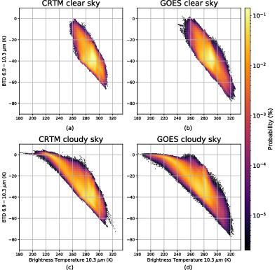
Synthetic infrared GOES-13 observations are generated from a high-resolution (4 km) Weather Research and Forecasting (WRF) model run over Argentina for a meteorological event of deep moist convection using two different radiative transfer models. The fast operational Community Radiative Transfer Model (CRTM) and the physics-based research model Atmospheric Radiative Transfer Simulator (ARTS) are compared with the available observations. CRTM shows good results at a low computational cost, and is a good candidate for operational use in the region. CRTM and ARTS synthetic satellite images show differences due to the treatment of the bulk scattering properties of the frozen hydrometeor species, especially around the cloud shield. With this WRF+CRTM configuration, a long-term evaluation is conducted over 12 hr forecasts from one month of data in a region of the South American autumn with four different initializations at 0000, 0600, 1200 and 1800 UTC, as operational at the National Meteorological Service of Argentina. The simulated and observed GOES-16 Advanced Baseline Imager (ABI) brightness temperatures (BTs) in the 6.9 m channel show good agreement with an averaged bias of K (RMSE 21.7 K), whereas the performances in the IR window channels show slightly larger averaged BT differences of 3.5 K (RMSE 15.2 K). BT differences between the 6.9 and 10.3 m channels indicate that the WRF+CRTM simulations underestimate low to mid-level clouds and to a lesser extent high-level clouds. In the BT (10.3 m) range between approximately 215 and 230 K, there is an overestimation of clouds with BT differences above 0 K between 6.9 and 10.3 m. This could be due to the misrepresentation of upper-level clouds.
中文翻译:

使用 WRF 和 GOES-13/16 观测评估从南美洲一个地区的辐射传输模型计算的合成卫星图像
合成红外 GOES-13 观测是从高分辨率(4 公里)天气研究和预报 (WRF) 模型中生成的,该模型在阿根廷上空运行,用于使用两种不同的辐射传输模型进行深潮湿对流气象事件。将快速运行的社区辐射传输模型 (CRTM) 和基于物理的研究模型大气辐射传输模拟器 (ARTS) 与可用观测进行了比较。CRTM 以较低的计算成本显示出良好的结果,是该地区运营使用的良好候选者。CRTM 和 ARTS 合成卫星图像显示出由于冷冻水凝物物种的体散射特性处理而产生的差异,尤其是在云盾周围。有了这个 WRF+CRTM 配置,阿根廷国家气象局在 0000、0600、1200 和 1800 UTC 四个不同的初始化时间,根据南美秋季地区一个月的数据进行了超过 12 小时的长期评估。6.9 中模拟和观察到的 GOES-16 高级基线成像仪 (ABI) 亮度温度 (BTs)m 通道显示出与平均偏差的良好一致性 K (RMSE 21.7 K),而在 IR 窗口通道中的性能表现出稍大的平均 BT 差异,为 3.5 K (RMSE 15.2 K)。6.9 和 10.3 之间的 BT 差异m 个通道表明 WRF+CRTM 模拟低估了低到中层云,并在较小程度上低估了高层云。在 BT (10.3m) 范围在大约 215 和 230 K 之间,在 6.9 和 10.3 之间存在高估云的 BT 差异高于 0 K 米。这可能是由于对上层云的误传。
更新日期:2021-08-04
中文翻译:
使用 WRF 和 GOES-13/16 观测评估从南美洲一个地区的辐射传输模型计算的合成卫星图像
合成红外 GOES-13 观测是从高分辨率(4 公里)天气研究和预报 (WRF) 模型中生成的,该模型在阿根廷上空运行,用于使用两种不同的辐射传输模型进行深潮湿对流气象事件。将快速运行的社区辐射传输模型 (CRTM) 和基于物理的研究模型大气辐射传输模拟器 (ARTS) 与可用观测进行了比较。CRTM 以较低的计算成本显示出良好的结果,是该地区运营使用的良好候选者。CRTM 和 ARTS 合成卫星图像显示出由于冷冻水凝物物种的体散射特性处理而产生的差异,尤其是在云盾周围。有了这个 WRF+CRTM 配置,阿根廷国家气象局在 0000、0600、1200 和 1800 UTC 四个不同的初始化时间,根据南美秋季地区一个月的数据进行了超过 12 小时的长期评估。6.9 中模拟和观察到的 GOES-16 高级基线成像仪 (ABI) 亮度温度 (BTs)m 通道显示出与平均偏差的良好一致性 K (RMSE 21.7 K),而在 IR 窗口通道中的性能表现出稍大的平均 BT 差异,为 3.5 K (RMSE 15.2 K)。6.9 和 10.3 之间的 BT 差异m 个通道表明 WRF+CRTM 模拟低估了低到中层云,并在较小程度上低估了高层云。在 BT (10.3m) 范围在大约 215 和 230 K 之间,在 6.9 和 10.3 之间存在高估云的 BT 差异高于 0 K 米。这可能是由于对上层云的误传。


 京公网安备 11010802027423号