当前位置:
X-MOL 学术
›
Environ. Sci. Technol.
›
论文详情
Our official English website, www.x-mol.net, welcomes your
feedback! (Note: you will need to create a separate account there.)
Spatial Modeling of Daily PM2.5, NO2, and CO Concentrations Measured by a Low-Cost Sensor Network: Comparison of Linear, Machine Learning, and Hybrid Land Use Models
Environmental Science & Technology ( IF 10.8 ) Pub Date : 2021-06-16 , DOI: 10.1021/acs.est.1c02653 Sakshi Jain 1 , Albert A Presto 2 , Naomi Zimmerman 1
Environmental Science & Technology ( IF 10.8 ) Pub Date : 2021-06-16 , DOI: 10.1021/acs.est.1c02653 Sakshi Jain 1 , Albert A Presto 2 , Naomi Zimmerman 1
Affiliation
|
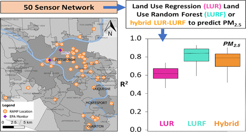
Previous studies have characterized spatial patterns of pollution with land use regression (LUR) models from distributed passive or filter samplers at low temporal resolution. Large-scale deployment of low-cost sensors (LCS), which typically sample in real time, may enable time-resolved or real-time modeling of concentration surfaces. The aim of this study was to develop spatiotemporal models of PM2.5, NO2, and CO using an LCS network in Pittsburgh, Pennsylvania. We modeled daily average concentrations in August 2016–December 2017 across 50 sites. Land use variables included 13 time-independent (e.g., elevation) and time-dependent (e.g., temperature) predictors. We examined two models: LUR and a machine-learning-enabled land use model (land use random forest, LURF). The LURF models outperformed LUR models, with increase in the average externally cross-validated R2 of 0.10–0.19. Using wavelet decomposition to separate short-lived events from the regional background, we also created time-decomposed LUR and LURF models. Compared to the standard model, this resulted in improvement in R2 of up to 0.14. The time-decomposed models were more influenced by spatial parameters. Mapping our models across Allegheny County, we observed that time-decomposed LURF models created robust PM2.5 predictions, suggesting that this approach may improve our ability to map air pollutants at high spatiotemporal resolution.
中文翻译:

通过低成本传感器网络测量的每日 PM 2.5、NO 2和 CO 浓度的空间建模:线性、机器学习和混合土地利用模型的比较
以前的研究使用来自分布式被动或过滤采样器的低时间分辨率的土地利用回归 (LUR) 模型来表征污染的空间模式。低成本传感器 (LCS) 的大规模部署(通常实时采样)可以实现浓度表面的时间分辨或实时建模。本研究的目的是建立 PM 2.5 , NO 2 的时空模型。和 CO 使用宾夕法尼亚州匹兹堡的 LCS 网络。我们模拟了 2016 年 8 月至 2017 年 12 月 50 个地点的日平均浓度。土地利用变量包括 13 个与时间无关(例如,海拔)和与时间有关(例如,温度)的预测变量。我们检查了两个模型:LUR 和支持机器学习的土地利用模型(土地利用随机森林,LURF)。LURF 模型优于 LUR 模型,平均外部交叉验证的R 2增加了 0.10–0.19。使用小波分解将短期事件与区域背景分离,我们还创建了时间分解 LUR 和 LURF 模型。与标准模型相比,这导致了R 2 的改进高达 0.14。时间分解模型受空间参数的影响更大。在阿勒格尼县绘制我们的模型,我们观察到时间分解的 LURF 模型创建了可靠的 PM 2.5预测,这表明这种方法可以提高我们以高时空分辨率绘制空气污染物的能力。
更新日期:2021-07-06
中文翻译:
通过低成本传感器网络测量的每日 PM 2.5、NO 2和 CO 浓度的空间建模:线性、机器学习和混合土地利用模型的比较
以前的研究使用来自分布式被动或过滤采样器的低时间分辨率的土地利用回归 (LUR) 模型来表征污染的空间模式。低成本传感器 (LCS) 的大规模部署(通常实时采样)可以实现浓度表面的时间分辨或实时建模。本研究的目的是建立 PM 2.5 , NO 2 的时空模型。和 CO 使用宾夕法尼亚州匹兹堡的 LCS 网络。我们模拟了 2016 年 8 月至 2017 年 12 月 50 个地点的日平均浓度。土地利用变量包括 13 个与时间无关(例如,海拔)和与时间有关(例如,温度)的预测变量。我们检查了两个模型:LUR 和支持机器学习的土地利用模型(土地利用随机森林,LURF)。LURF 模型优于 LUR 模型,平均外部交叉验证的R 2增加了 0.10–0.19。使用小波分解将短期事件与区域背景分离,我们还创建了时间分解 LUR 和 LURF 模型。与标准模型相比,这导致了R 2 的改进高达 0.14。时间分解模型受空间参数的影响更大。在阿勒格尼县绘制我们的模型,我们观察到时间分解的 LURF 模型创建了可靠的 PM 2.5预测,这表明这种方法可以提高我们以高时空分辨率绘制空气污染物的能力。


 京公网安备 11010802027423号