当前位置:
X-MOL 学术
›
Remote Sens. Ecol. Conserv.
›
论文详情
Our official English website, www.x-mol.net, welcomes your
feedback! (Note: you will need to create a separate account there.)
Simultaneous monitoring of vegetation dynamics and wildlife activity with camera traps to assess habitat change
Remote Sensing in Ecology and Conservation ( IF 3.9 ) Pub Date : 2021-06-14 , DOI: 10.1002/rse2.222 Catherine Sun 1 , Christopher Beirne 1 , Joanna M. Burgar 1, 2 , Thomas Howey 1 , Jason T. Fisher 2 , A. Cole Burton 1
Remote Sensing in Ecology and Conservation ( IF 3.9 ) Pub Date : 2021-06-14 , DOI: 10.1002/rse2.222 Catherine Sun 1 , Christopher Beirne 1 , Joanna M. Burgar 1, 2 , Thomas Howey 1 , Jason T. Fisher 2 , A. Cole Burton 1
Affiliation
|
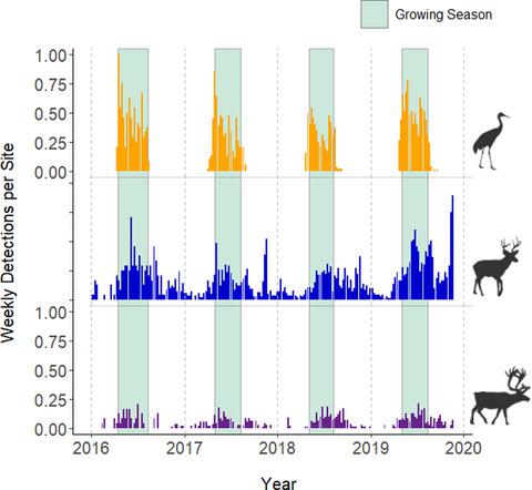
Vegetation phenology and productivity drive resource use by wildlife. Vegetation dynamics also reveal patterns of habitat disturbance and recovery. Monitoring these fine-scale vegetation patterns over large spatiotemporal extents can be difficult, but camera traps (CTs) commonly used to survey wildlife populations also collect data on local habitat conditions. We used CTs (n = 73) from 2016 to 2019 to assess impacts of habitat change in a boreal landscape of northern Canada, where seismic lines for petroleum exploration disturbed wildlife habitat and prompted vegetation restoration efforts. First, we quantified vegetation dynamics from CTs, comparing them to satellite-based estimates that are typically used to monitor vegetation at broad spatial scales. We then used understory phenology and productivity estimated from CT time-lapse images to assess vegetation recovery on seismic lines. Finally, we related vegetation dynamics with the habitat use of three wildlife species: sandhill cranes Grus canadensis, woodland caribou Rangifer tarandus, and white-tailed deer Odocoileus virginianus. CTs provided unique insight into vegetation dynamics that were different from signals measured by satellites, with temporally inconsistent and even some negative correlations between CT and satellite metrics. We found some indication of vegetation recovery on seismic lines that had received restoration treatment, with understory patterns more similar to undisturbed habitat than to seismic lines that did not receive restoration treatment. CTs also provided inferences about wildlife activity related to vegetation resources, which approaches using satellite data failed to detect. Wildlife habitat use tracked vegetation phenology, but did not always increase with vegetation productivity at weekly, 16-day, or annual intervals. Instead, associations with vegetation productivity depended on species, temporal scale, and productivity metrics. Given the widespread and growing use of CTs to monitor terrestrial wildlife, we recommend their use to simultaneously monitor habitat conditions to better understand the mechanisms that govern wildlife habitat use in changing environments.
中文翻译:

使用相机陷阱同时监测植被动态和野生动物活动,以评估栖息地变化
植被物候和生产力推动野生动物对资源的利用。植被动态也揭示了栖息地干扰和恢复的模式。在大时空范围内监测这些精细的植被模式可能很困难,但通常用于调查野生动物种群的相机陷阱 (CT) 也收集有关当地栖息地条件的数据。我们使用 2016 年至 2019 年的 CT(n = 73)来评估栖息地变化对加拿大北部北方景观的影响,其中石油勘探的地震线扰乱了野生动物栖息地并促进了植被恢复工作。首先,我们量化了 CT 中的植被动态,并将其与基于卫星的估计进行了比较,这些估计通常用于在广泛的空间尺度上监测植被。然后,我们使用从 CT 延时图像估计的林下物候和生产力来评估地震线上的植被恢复。最后,我们将植被动态与三种野生动物物种的栖息地利用联系起来:沙丘鹤Grus canadensis、林地驯鹿Rangifer tarandus和白尾鹿Odocoileus virginianus. CT 提供了对植被动态的独特见解,这与卫星测量的信号不同,CT 和卫星指标之间存在时间上的不一致甚至一些负相关。我们在接受恢复处理的地震线上发现了一些植被恢复迹象,与未接受恢复处理的地震线相比,下层模式更类似于未受干扰的栖息地。CT 还提供了与植被资源相关的野生动物活动的推论,而使用卫星数据的方法未能检测到这些活动。野生动物栖息地使用跟踪的植被物候,但并不总是随着每周、每 16 天或每年一次的植被生产力而增加。相反,与植被生产力的关联取决于物种、时间尺度和生产力指标。
更新日期:2021-06-14
中文翻译:
使用相机陷阱同时监测植被动态和野生动物活动,以评估栖息地变化
植被物候和生产力推动野生动物对资源的利用。植被动态也揭示了栖息地干扰和恢复的模式。在大时空范围内监测这些精细的植被模式可能很困难,但通常用于调查野生动物种群的相机陷阱 (CT) 也收集有关当地栖息地条件的数据。我们使用 2016 年至 2019 年的 CT(n = 73)来评估栖息地变化对加拿大北部北方景观的影响,其中石油勘探的地震线扰乱了野生动物栖息地并促进了植被恢复工作。首先,我们量化了 CT 中的植被动态,并将其与基于卫星的估计进行了比较,这些估计通常用于在广泛的空间尺度上监测植被。然后,我们使用从 CT 延时图像估计的林下物候和生产力来评估地震线上的植被恢复。最后,我们将植被动态与三种野生动物物种的栖息地利用联系起来:沙丘鹤Grus canadensis、林地驯鹿Rangifer tarandus和白尾鹿Odocoileus virginianus. CT 提供了对植被动态的独特见解,这与卫星测量的信号不同,CT 和卫星指标之间存在时间上的不一致甚至一些负相关。我们在接受恢复处理的地震线上发现了一些植被恢复迹象,与未接受恢复处理的地震线相比,下层模式更类似于未受干扰的栖息地。CT 还提供了与植被资源相关的野生动物活动的推论,而使用卫星数据的方法未能检测到这些活动。野生动物栖息地使用跟踪的植被物候,但并不总是随着每周、每 16 天或每年一次的植被生产力而增加。相反,与植被生产力的关联取决于物种、时间尺度和生产力指标。


 京公网安备 11010802027423号