Resources, Conservation and Recycling ( IF 11.2 ) Pub Date : 2021-06-09 , DOI: 10.1016/j.resconrec.2021.105709 Ying Mao , Yilin Liu , La Zhuo , Wei Wang , Meng Li , Bianbian Feng , Pute Wu
|
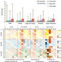
The water footprint of crop production (WFP) is among the most comprehensive agricultural water-consumption evaluation tools because it describes the amount, type, and location of water consumed. However, existing literatures on WFP quantification and evaluation are only aimed at a specific spatial level, and currently, there is a lack of quantitative research on the effects of different spatial levels on the variation in WFP. Herein, we calculated the spatial distribution of wheat WFPs in China from 2000 to 2014 at five different spatial levels: crop field, county, river sub-basin, provincial, and large river basin. In addition, we analysed and compared the key driving forces of wheat WFP at these spatial levels, focusing on meteorological and human management factors. Each spatial level had distinct spatial distributions. Human management factors demonstrated more significant effects on the WFP of large river basins, but the meteorological factors were the key drivers at smaller spatial levels. In conclusion, our study quantitatively revealed a non-negligible effect of spatial scale on WFP. Thus, for large river basins, agricultural water resource managers at each spatial level must clarify their different priorities across spatial levels while formulating water-saving and regulation measures.


 京公网安备 11010802027423号